
Location of Mabalane
Mabalane is a village in Kgatleng District of Botswana.
Mabalane is a village in Kgatleng District of Botswana.
It is located 55 km east of Gaborone, close to the border with South Africa.
It has a primary school.
The population was 814 in 2001 census. [1]
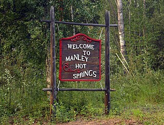
Manley Hot Springs is a census-designated place (CDP) in Yukon-Koyukuk Census Area, Alaska, United States. At the 2020 census the population was 169, up from 89 in 2010.
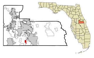
Southchase is a census-designated place and an unincorporated area in Orange County, Florida, United States. The population was 15,921 at the 2010 census. It is part of the Orlando–Kissimmee–Sanford, Florida Metropolitan Statistical Area.

Edge Hill is a city in Glascock County, Georgia, United States. The population was 24 at the 2010 census. It is the smallest incorporated city in Georgia by population and ties for the smallest incorporated city in Georgia by area.

Amherst Center is a census-designated place (CDP) in the town of Amherst in Hampshire County, Massachusetts, United States. The CDP covers the primary village in town. The population was 19,065 at the 2010 census, out of a total town population of 37,819. It is part of the Springfield, Massachusetts Metropolitan Statistical Area.

Nashwauk is a city in Itasca County, Minnesota, United States. The population was 983 at the 2010 census.

Clinton is a village in Oneida County, New York, United States. The population was 1,942 at the 2010 census. It was named for George Clinton, the first Governor of New York.

Sugar Grove is a village in Fairfield County, Ohio, United States. The population was 426 at the 2010 census.

Roff is a town in Pontotoc County, Oklahoma, United States. The population was 725 at the 2010 census.

Upper Paxton Township is a township in Dauphin County, Pennsylvania, United States. The population was 4,161 at the 2010 census.

Spruce Creek Township is a township in Huntingdon County, Pennsylvania, United States. The population was 240 at the 2010 census.

Union Township is a township in Mifflin County, Pennsylvania, United States. The population was 3,313 at the 2000 census.

Belmont is a town in Pleasants County, West Virginia, United States. It is part of the Parkersburg-Marietta-Vienna, WV-OH Metropolitan Statistical Area. The population was 903 at the 2010 census.

Lebanon is a town in Dodge County, Wisconsin, United States. The population was 1,664 at the 2000 census. The census-designated place of Lebanon is located in the town, as are the unincorporated communities of Old Lebanon and Sugar Island.

Harrison Township is a township in Allegheny County in the U.S. state of Pennsylvania. The population was 10,461 at the 2010 census. Pennsylvania Route 28 passes through Harrison Township connecting Kittanning to the northeast and Pittsburgh to the southwest. Allegheny Technologies has extensive steel mill facilities in Harrison Township, including its Allegheny Ludlum Brackenridge Works. Harrison Township is located at the far northeast corner of Allegheny County. Its northern border is the Butler County line and the Allegheny River forms the township's eastern boundary with Westmoreland County. Its northeast corner also touches Armstrong County.
Lazovsky District is an administrative and municipal district (raion), one of the twenty-two in Primorsky Krai, Russia. It is located in the southeast of the krai on the eastern slopes of the Sikhote-Alin mountain range and its southern spurs. The area of the district is 4,691.5 square kilometers (1,811.4 sq mi). Its administrative center is the rural locality of Lazo. Population: 14,235 (2010 Census); 17,521 (2002 Census); 21,311 (1989 Census). The population of Lazo accounts for 24.1% of the district's total population.
Kinards is an unincorporated community in Laurens and Newberry counties in the U.S. state of South Carolina. It had a post office that now is closed permanently, with the ZIP Code of 29355. Kinards was first established as Kinards Turnout when the post office opened February 26, 1856. The population of the ZCTA for ZIP Code 29355 was 801 at the 2000 census.
Potrkanje is a village in the municipality of Knjaževac, Serbia. According to the 2002 census, the village has a population of 83 people.
Jablanica (Višegrad) is a village in the municipality of Višegrad, Bosnia and Herzegovina.
Joffre is a census-designated place located in Smith Township, Washington County in the state of Pennsylvania. The community is located in northern Washington County about 3 miles east of the borough of Burgettstown. As of the 2010 census the population was 536 residents.
Pat Rud Pey is a village in Shahidabad Rural District, Bandpey-ye Gharbi District, Babol County, Mazandaran Province, Iran. At the 2006 census, its population was 462, in 127 families.
| Urban villages | 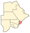 | |
|---|---|---|
| Rural villages | ||
Coordinates: 24°37′36″S26°22′49″E / 24.62667°S 26.38028°E
| | This Botswana location article is a stub. You can help Wikipedia by expanding it. |