Mount Pinbarren is a national park in Queensland, Australia, 129 km north of Brisbane. It is located in Pinbarren, a locality in the Shire of Noosa. Mount Pinbarren lies within the South East Queensland bioregion and the Mary River catchment area.
The Curtain Fig National Park is a national park on the Atherton Tableland in Far North Queensland, Australia. The National Park is located near Yungaburra. Its most valued features are its once regionally common, now endangered Mabi forests including a huge strangler fig which attracts up to 100 000 visitors per year, locally known as the Curtain Fig Tree, plus a near threatened, locally endemic tree-kangaroo species i.e. the Lumholtz's tree-kangaroo which finds refuge inside this protected area
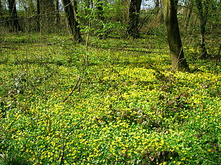
In forestry and ecology, understory, or understorey, also known as underbrush or undergrowth, includes plant life growing beneath the forest canopy without penetrating it to any great extent, but above the forest floor. Only a small percentage of light penetrates the canopy so understory vegetation is generally shade-tolerant. The understory typically consists of trees stunted through lack of light, other small trees with low light requirements, saplings, shrubs, vines and undergrowth. Small trees such as holly and dogwood are understory specialists.

A savanna or savannah is a mixed woodland-grassland ecosystem characterised by the trees being sufficiently widely spaced so that the canopy does not close. The open canopy allows sufficient light to reach the ground to support an unbroken herbaceous layer consisting primarily of grasses. According to Britannica, there exists four savanna forms; savanna woodland where trees and shrubs form a light canopy, tree savanna with scattered trees and shrubs, shrub savanna with distributed shrubs, and grass savanna where trees and shrubs are mostly nonexistent.

Tropical and subtropical moist broadleaf forests (TSMF), also known as tropical moist forest, is a subtropical and tropical forest habitat type defined by the World Wide Fund for Nature.
The Tasmanian temperate rain forests are a temperate broadleaf and mixed forests ecoregion in western Tasmania. The ecoregion is part of the Australasian realm, which includes Tasmania and Australia, New Zealand, New Guinea, New Caledonia, and adjacent islands.

Mount Bartle Frere is the highest mountain in Queensland at an elevation of 1,611 metres (5,285 ft). The mountain was named after Sir Henry Bartle Frere, a British colonial administrator and then president of the Royal Geographical Society by George Elphinstone Dalrymple in 1873. Bartle Frere was British Governor of Cape Colony at the outset of the Anglo-Zulu War.

Curtain Fig Tree is a heritage-listed tree at Curtain Fig Tree Road, Yungaburra, Tablelands Region, Queensland, Australia. It is one of the largest trees in Tropical North Queensland, Australia, and one of the best known attractions on the Atherton Tableland. It was added to the Queensland Heritage Register on 3 December 2009.

Lumholtz's tree-kangaroo is a rare, long-tailed marsupial found in rainforests in northeastern Australia. Like most tree-kangaroos, it lives alone in trees and feeds on plant matter. It belongs to the macropod family (Macropodidae) with kangaroos, and carries its young in a pouch like other marsupials. It is threatened by climate change and diseases, and is found in the hilly, fertile Atherton Tableland near Cairns in north east Queensland.

Alloxylon flammeum, commonly known as the Queensland tree waratah or red silky oak, is a medium-sized tree of the family Proteaceae found in the Queensland tropical rain forests of northeastern Australia. It has shiny green elliptical leaves up to 18 cm (7.1 in) long, and prominent orange-red inflorescences that appear from August to October, followed by rectangular woody seed pods that ripen in February and March. Juvenile plants have large deeply lobed pinnate leaves. Previously known as Oreocallis wickhamii, the initial specimen turned out to be a different species to the one cultivated and hence a new scientific name was required. Described formally by Peter Weston and Mike Crisp in 1991, A. flammeum was designated the type species of the genus Alloxylon. This genus contains the four species previously classified in Oreocallis that are found in Australasia.

The Sydney Turpentine-Ironbark Forest (STIF) is a wet sclerophyll forest community of Sydney, New South Wales, Australia, that is typically found in the Inner West and Northern region of Sydney. It is also among the three of these plant communities which have been classified as Endangered, under the New South Wales government's Threatened Species Conservation Act 1995, with only around 0.5% of its original pre-settlement range remaining.

A plant community is a collection or association of plant species within a designated geographical unit, which forms a relatively uniform patch, distinguishable from neighboring patches of different vegetation types. The components of each plant community are influenced by soil type, topography, climate and human disturbance. In many cases there are several soil types present within a given plant community. This is because the soil type within an area is influenced by two factors, the rate at which water infiltrates or exits the soil, as well as the rate at which organic matter enters or decays from the soil. Plant communities are studied substantially by ecologists, due to providing information on the effects of dispersal, tolerance to environmental conditions, and response to disturbance of a variety of plant species, information valuable to the comprehension of various plant community dynamics.

The Eastern Australian temperate forests is a broad ecoregion of open forest on uplands starting from the east coast of New South Wales in the South Coast to southern Queensland, Australia. Although dry sclerophyll and wet sclerophyll eucalyptus forests predominate within this ecoregion, a number of distinguishable rainforest communities are present as well.

Southern Afrotemperate Forest is a kind of tall, shady, multilayered indigenous South African forest. This is the main forest-type in the south-western part of South Africa, naturally extending from the Cape Peninsula in the west, as far as Port Elizabeth in the east. In this range, it usually occurs in small forest pockets, surrounded by fynbos vegetation.
Tropical vegetation is any vegetation in tropical latitudes. Plant life that occurs in climates that are warm year-round is in general more biologically diverse that in other latitudes. Some tropical areas may receive abundant rain the whole year round, but others have long dry seasons which last several months and may vary in length and intensity with geographic location. These seasonal droughts have great impact on the vegetation, such as in the Madagascar spiny forests.
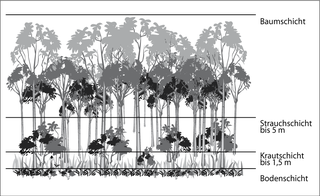
Stratification in the field of ecology refers to the vertical layering of a habitat; the arrangement of vegetation in layers. It classifies the layers of vegetation largely according to the different heights to which their plants grow. The individual layers are inhabited by different animal and plant communities (stratozones).
Tully Training Area is a heritage-listed rainforest in a military training area at Tully-Cardstone Road, Tully, Queensland, Australia. It was added to the Australian Commonwealth Heritage List on 22 June 2004.
Samuel Justin Dansie was an Australian forester and botanist who was an influential early figure associated with the emergence of a conservation ethos in the use and management of the Wet Tropical rainforests of Northern Queensland. During his 36-year tenure within the Queensland Forestry Department, Dansie was instrumental in identifying and securing the protection of a number of key conservation areas, both within and outside of state forests in the region.

The Blue Mountains and Southern Highlands Basalt Forests are a sclerophyll temperate forest community that stretch from the northern fringes of the Blue Mountains to the Southern Highlands. Featuring both wet and dry sclerophyll forests, as well as small rainforest pockets, the community features tall (30m+) and open eucalypt forests and woodlands that lie on igneous rock.

Rainforests and vine thickets are a major vegetation group in Australia. It consists of temperate to tropical rainforests, monsoon forests, and vine thickets. Rainforests and vine thickets are generally found in small pockets across the eastern and northern portions of the continent, including western Tasmania, eastern New South Wales, eastern Queensland, the northern portion of the Northern Territory, and the Kimberley Region of northeastern Western Australia.


