Barabanki district is one of the five districts of Ayodhya division in the central Awadh region of Uttar Pradesh, India. Barabanki city is the administrative headquarters of Barabanki district. Total area of Barabanki district is 3891.5 Sq. km.

Maharajganj is a town and nagar panchayat in Rae Bareli district, Uttar Pradesh, India. It serves as the headquarters of a tehsil. As of 2011, its population is 6,673, in 1,037 households.
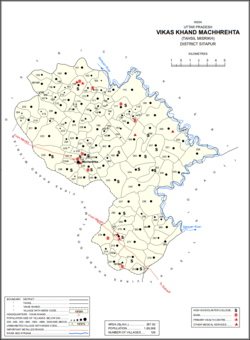
Misrikh is a city and a municipal board in Sitapur district in the Indian state of Uttar Pradesh.
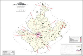
Sandila is a town and nagar palika parishad in Hardoi district in the Indian state of Uttar Pradesh. It serves as a tehsil headquarters within the district. Located midway between Hardoi and Lucknow, Sandila is a well-connected town with roads leading in all directions and a major broad gauge rail line passing through the south side of town. Important industries include sweets — its laddus are especially well-known — as well as beedi production and zardozi work.

Sidhauli is a town and an Ideal Notified Area Council in Sitapur district in the Indian state of Uttar Pradesh. It comes under Lucknow division and is in the Awadh region of eastern Uttar Pradesh. Four-lane National Highway 24 passes from the centre of the town. It comes under Mohanlalganj. Sidhauli is also a Sidhauli of Uttar Pradesh Legislative Assembly. It is the Headquarters of Tehsil Sidhauli and Sidhauli Community Development Block. Sidhauli Block comprises 306 Gram Panchayats.
Mahishya is a Bengali Hindu traditionally agrarian caste, and formed the largest caste in undivided Bengal. Mahisyas were, and still are, extremely diverse caste consisting of all possible classes in terms of material conditions and ranks.
Bishwanath is an upazila of Sylhet District in the Division of Sylhet, Bangladesh.

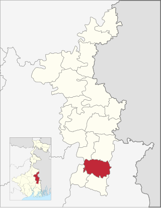
Sandeshkhali I is a community development block that forms an administrative division in Basirhat subdivision of North 24 Parganas district in the Indian state of West Bengal.
Bhumihar, also locally called Bhuinhar and Babhan, is a Hindu caste mainly found in Bihar, the Purvanchal region of Uttar Pradesh, Jharkhand, the Bundelkhand region of Madhya Pradesh, and Nepal.

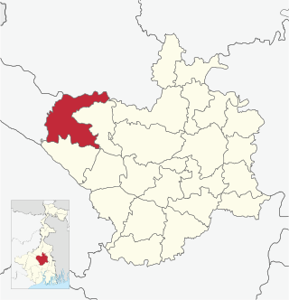
Matigara is a community development block that forms an administrative division in the Siliguri subdivision of the Darjeeling district in the Indian state of West Bengal.

Bamangola is a community development block that forms an administrative division in Malda Sadar subdivision of Malda district in the Indian state of West Bengal.
Chakdaha is a community development block that forms an administrative division in Kalyani subdivision of Nadia district in the Indian state of West Bengal.
Ausgram II is a community development block. It is a municipality in Bardhaman Sadar North subdivision of Purba Bardhaman district in the Indian state of West Bengal.

Murarmau is a village in Sareni block of Rae Bareli district, Uttar Pradesh, India. It is located 21 km from Lalganj, the tehsil headquarters. Murarmau historically served as the seat of the largest taluqdar estate in the district, held by the most senior branch of the Tilokchandi Bais. As of 2011, it has a population of 2,999 people, in 523 households. It has one primary school and no healthcare facilities. Murarmau serves as the headquarters of a nyaya panchayat which also includes 9 other villages.

Paho, also spelled Pahu, is a village in Khiron block of Rae Bareli district, Uttar Pradesh, India. It is located near the road from Raebareli to Mauranwan and Unnao, close to the border with Unnao district. It is 18 km away from Lalganj, the tehsil headquarters. As of 2011, Paho has a population of 5,620 people, in 1,088 households. It has two primary schools and no healthcare facilities, and it hosts a weekly haat but not a permanent market. It is the seat of a nyaya panchayat which also includes 7 other villages.

Khajurgaon is a village in Lalganj block of Rae Bareli district, Uttar Pradesh, India. It is located on the bank of the Ganges, 12 km from Lalganj, the block and tehsil headquarters. As of 2011, it has a population of 5,916 people, in 1,067 households. It has 5 primary schools and 1 community health centre. It serves as the headquarters of a nyaya panchayat which also includes 12 other villages.

Shahgarh is a village and community development block headquarters in Gauriganj tehsil of Amethi district, Uttar Pradesh, India. As of 2011, it has a population of 3,201 people, in 525 households. It historically was the seat of a taluqdari estate held by a branch of the Bandhalgoti Rajputs. Today it serves as the seat of a nyaya panchayat which also includes 13 other villages.

Shri Ramkrishna Bhargava is an Indian politician from the Bharatiya Janata Party (BJP), representing the 153-Misrikh constituency in Sitapur district, Uttar Pradesh. He has been elected multiple times as a Member of the Legislative Assembly (MLA) and has served in various capacities throughout his political career.
Anogi (अनोगी) located at 27°19'56.2"N 80°39'44.9"E is a village in Machhrehta block of Misrikh tehsil in Sitapur, Uttar Pradesh, India. It belongs to the Lucknow Division. As per 2009 stats, it is also a gram panchayat. The village pin code is 261403 and postal head office is Aurangabad (Sitapur).