
Midway Point is a residential locality in the local government area (LGA) of Sorell in the South-east LGA region of Tasmania. The locality is about 5 kilometres (3.1 mi) south-west of the town of Sorell. The 2016 census recorded a population of 2859 for the state suburb of Midway Point. It is located on a small peninsula with Orielton Lagoon on its eastern side and Pittwater on its southern and western sides. The suburb meets the mid-way point of the Sorell Causeway from Hobart to Sorell, hence the name. Mcgees Bridge is connected to Midway Point on the Pittwater side. The suburb lies close to Hobart International Airport and is approximately 21 km to Hobart via the Tasman Highway. In recent years Midway Point has become a popular commuter town for people working in Hobart.

The West Coast of Tasmania is one of the regions of Tasmania in Australia. It is mainly isolated rough country and is associated with wilderness, mining and tourism. It served as the location of an early convict settlement in the early history of Van Diemen's Land, and contrasts sharply with the more developed and populous northern and eastern parts of the island state.

Hells Gates is the name of the mouth of Macquarie Harbour on the West Coast of Tasmania, Australia.
Trial Harbour is a rural locality in the local government area (LGA) of West Coast in the North-west and west LGA region of Tasmania. The locality is about 20 kilometres (12 mi) south-west of the town of Zeehan. The 2016 census has a population of 24 for the state suburb of Trial Harbour.

Hamilton is a rural locality in the local government area (LGA) of Central Highlands in the Central LGA region of Tasmania. The locality is about 73 kilometres (45 mi) north-west of the city of Hobart. The 2016 census recorded a population of 241 for the suburb of Hamilton.
Blackstone Heights is a rural/residential locality in the local government areas (LGA) of Meander Valley (97.5%) and West Tamar (2.5%) in the Launceston LGA region of Tasmania. The locality is about 34 kilometres (21 mi) east of the town of Westbury. The 2016 census recorded a population of 1270 for the state suburb of Blackstone Heights. It is an outer suburb of Launceston.
Dowsing Point is a residential locality in the local government area (LGA) of Glenorchy in the Hobart LGA region of Tasmania. The locality is about 2 kilometres (1.2 mi) north-east of the town of Glenorchy. The 2016 census recorded a population of 85 for the state suburb of Dowsing Point.
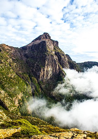
South West Tasmania is a region in Tasmania that has evoked curiosity and wonder during the period of European presence on the island.
Bonnet Hill is a residential locality in the local government area (LGA) of Kingborough in the Hobart LGA region of Tasmania, Australia. The locality is about 2 kilometres (1.2 mi) east of the town of Kingston. The 2016 census recorded a population of 505 for the state suburb of Bonnet Hill.
Boat Harbour is a rural locality in the local government area (LGA) of Waratah–Wynyard in the North-west and west LGA region of Tasmania. The locality is about 11 kilometres (6.8 mi) north-west of the town of Wynyard. The 2016 census has a population of 273 for the state suburb of Boat Harbour.

Currie is a rural residential locality in the local government area (LGA) of King Island in the North-west and west LGA region of Tasmania. The 2016 census recorded a population of 768 for the state suburb of Currie. It is the largest township on, and is the administrative centre of, King Island, at the western entrance to Bass Strait.
Dodges Ferry is a rural / residential locality in the local government area (LGA) of Sorell in the South-east LGA region of Tasmania. The locality is about 13 kilometres (8.1 mi) south-east of the town of Sorell. The 2016 census recorded a population of 2467 for the state suburb of Dodges Ferry.

Binalong Bay is a rural locality in the local government area (LGA) of Break O'Day in the North-east LGA region of Tasmania. The locality is about 12 kilometres (7.5 mi) north-east of the town of St Helens. The 2016 census recorded a population of 290 for the state suburb of Binalong Bay.

Riverside is a rural and urban locality in the local government areas of Meander Valley and West Tamar in the Launceston region of Tasmania, Australia. The locality is about 39 kilometres (24 mi) south-east of the town of Beaconsfield. The 2016 census has a population of 6472 for the state suburb of Riverside. It is a residential suburb 5 kilometres (2.5 mi) north-west of the central business district of Launceston, Tasmania's second largest city. The West Tamar Highway runs through the suburb, adjoining Riverside to the West Tamar, which includes small towns such as Beaconsfield, and Beauty Point. Riverside is part of the West Tamar Council local government area. The suburb is now Launceston's largest by population, narrowly ahead of Kings Meadows. The main shopping centre opened in the 1960s and includes: a Woolworths supermarket, a bakery, a pharmacist and some local businesses.
Granville Harbour is a rural locality in the local government area (LGA) of West Coast in the North-west and west LGA region of Tasmania. The locality is about 35 kilometres (22 mi) north-west of the town of Zeehan. The 2016 census has a population of 27 for the state suburb of Granville Harbour.
Trowutta is a rural locality in the local government area of Circular Head in the North West region of Tasmania. It is located about 29 kilometres (18 mi) south of the town of Smithton. The 2016 census determined a population of 92 for the state suburb of Trowutta.
Kindred is a rural locality in the local government area of Central Coast, in the North West region of Tasmania. It is located about 20 kilometres (12 mi) south-west of the town of Devonport. The 2021 census determined a population of 214 for the state suburb of Kindred.
Nietta is a rural locality in the local government area of Central Coast, in the North West region of Tasmania. It is located about 44 kilometres (27 mi) south-west of the town of Devonport. The 2021 census recorded a population of 63 for the state suburb of Nietta.
Sprent is a rural locality and town in the local government area of Central Coast, in the North West region of Tasmania. It is located about 25 kilometres (16 mi) south-west of the town of Devonport. The 2021 census recorded a population of 160 for the state suburb of Sprent.
Macquarie Plains is a rural locality in the local government area of Derwent Valley in the South-east region of Tasmania. The locality is about 17 kilometres (11 mi) north-west of the town of New Norfolk. The 2016 census has a population of 44 for the state suburb of Macquarie Plains.
