
Burlington is a town in Hartford County, Connecticut, United States. The town is part of the Northwest Hills Planning Region.

The Hills is a village in Travis County, Texas, United States. The population was 2,613 at the 2020 census, making it the largest village in Texas. It is a suburb of Austin.

Plover is a village in Portage County, Wisconsin, United States. A suburb of Stevens Point, it is part of the Stevens Point Micropolitan Statistical Area. The population was 13,519 at the 2020 United States census.
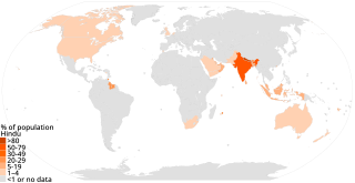
Hinduism has approximately 1.2 billion adherents worldwide. Hinduism is the third largest religion in the world behind Christianity (31.5%) and Islam (23.3%).

Sirsa district is the largest district of Haryana state by Area. Sirsa is the district headquarters. It is located on National Highway 9 and 250 kilometres (160 mi) from the capital Delhi. On 1 September 1975, Sirsa became a district by taking Sirsa and Dabwali tahsils from Hisar District. There are a total of 342 villages in Sirsa district.

Karimnagar district is one of the 33 districts of the Indian state of Telangana. Karimnagar city is its administrative headquarters. The district shares boundaries with Peddapalli, Jagityal, Sircilla, Siddipet, Jangaon, Hanamkonda district and Jayashankar Bhupalapally districts.

Perambalur is a town in the Indian state of Tamil Nadu. It is the headquarters of Perambalur district and Perambalur taluk (sub-district). As of 2011 census, the town had a population of 49,648.

Maymont is a village in the Canadian province of Saskatchewan within the Rural Municipality of Mayfield No. 406 and Census Division No. 16. It is 90 kilometres (56 mi) north-west of the city of Saskatoon.
Bishnupur I is a community development block that forms an administrative division in the Alipore Sadar subdivision of the South 24 Parganas district in the Indian state of West Bengal.
Falta is a community development block that forms an administrative division in the Diamond Harbour subdivision of the South 24 Parganas district in the Indian state of West Bengal.
Mandor is an ILRC and village in Phagi Tehsil in Jaipur district, Rajasthan.
Chittora is a village and revenue block (ILRC) in Phagi Tehsil in Jaipur district, Rajasthan.
Mandi is a patwar circle and village in Phagi Tehsil in Jaipur district, Rajasthan. Mandi is also a patwari circle for nearby villages, Mohanpura Ranwa and Rampura Railway.
Gopalpura is a patwar circle and village in ILRC Madhorajpura in Phagi tehsil in Jaipur district, Rajasthan. Gopalpura is also a patwar circle for nearby villages, Ramsinghpura and Shri Ramjipura.
Chandma Kalan is a patwar circle and village in ILRC Madhorajpura in Phagi tehsil in Jaipur district, Rajasthan. Chandma Kalan is also a patwar circle for nearby villages, Ajnota, Unt Ka Khera, Chandarpura and Bisaloo.
Didawata is a patwar circle and village in ILRC Madhorajpura in Phagi tehsil in Jaipur district, Rajasthan. Didawata is also a patwar circle for nearby villages, Bhanpura, Mukand Pura, Sangrampura, Hanootiya Kalan and Hanootiya Khurd.

Sadipur Bargadha is a village in Lalganj block of Rae Bareli district, Uttar Pradesh, India. As of 2011, it has a population of 352 people, in 72 households. It has no schools and no healthcare facilities, and it does not host a permanent market or a weekly haat. It belongs to the nyaya panchayat of Khajurgaon.

