
Tenkasi is a town and headquarters of the Tenkasi district in Indian state of Tamil Nadu.

Hailakandi district is one of the 33 districts of Assam state in north-eastern India. It makes up the Barak Valley alongside Cachar and Karimganj. It was constituted as a civil subdivision on 1 June 1869. Subsequently, it was upgraded to a district in 1989, when it was split from Cachar district.
Hamirpur is a city and a municipal board in Hamirpur district in the Indian state of Uttar Pradesh. Located just above the confluence of the Yamuna and Betwa rivers, it is the administrative headquarters of Hamirpur district.
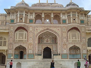
Jaipur District is a district of the state of Rajasthan in Northern India. The city of Jaipur, which is Rajasthan's capital and largest city, is the district headquarters. It is the tenth most populous district in India.
Kishangarh Renwal is a city and a municipality, panchayat samiti in Jaipur district in the Rajasthan state of India.State Highway 19A passing through the city.

Thiruvananthapuram Parliamentary Constituency is one of the 20 parliamentary constituencies in Kerala, India. It is located in Thiruvananthapuram district and encompasses the major part of Thiruvananthapuram city, the capital of Kerala State.

Gauriganj is a city, tehsil and administrative headquarters of Amethi district in Ayodhya division, Uttar Pradesh, India. It is situated about 126 km from Lucknow, the capital of Uttar Pradesh. It is located in Eastern Uttar Pradesh. Before July 2010, Gauriganj was part of Sultanpur district and then taking Gauriganj, Amethi, Jais, Jagdispur and Salon, formed a new district called Chatrapati Sahuji Maharaj Nagar, later named Gauriganj and now Amethi. Gauriganj is connected with State Highway 34 and National Highway 128.

Saran district is one of the thirty-eight districts of Indian state of Bihar. The district, part of Saran Division, is also known as Chhapra district after the headquarters of the district, Chhapra. It is considered as one of the richest Zamindari of Bihar after Raj Darbhanga, Hathwa Raj, Bettiah Raj and Raj Najarganj, Saran Raj.

Phagi is a tehsil and a panchayat samiti, near city of Jaipur in Jaipur district in the state of Rajasthan, India. It has an average elevation of 383 m (1,257 ft). Phagi is also one of the Town in Phagi Tehsil in Dudu District. Phagi is located on the intersection of SH2 and SH12 of Rajasthan.
Danta Ramgarh is a census town and a tehsil tehsil of Sikar district in the Indian state of Rajasthan. Ex vice president of India Bhairon Singh Shekhawat, was born in village Khachariyaws close by to east of Ramgarh. Dantaramgarh tehsil is the largest tehsil in Sikar district and its population is above 300,000. This village is famous for its strategic fort built by Guman Singh Ladkhani in the year 1744. The topography of the surroundings from the top of the fort is breaths taking. Baba Balinath was a very popular saint about 400 years back. He is regarded as a village deity in the area..
Gandhigram is a town in Tripura, India. located around 10 km from city centre Agartala. It comes under Sadar district. It has an old age home called Sandhyoneer.
Datooli is a village in Bhojpura patwar circle in Phagi Tehsil in Jaipur district, Rajasthan.
Rampura Railway is a village in Mandi patwar circle in Phagi Tehsil in Jaipur district, Rajasthan.
Mohanpura Ranwa is a village in Mandi patwar circle in Phagi tehsil in Jaipur district, Rajasthan.
Gopalpura is a patwar circle and village in ILRC Madhorajpura in Phagi tehsil in Jaipur district, Rajasthan. Gopalpura is also a patwar circle for nearby villages, Ramsinghpura and Shri Ramjipura.
Chandma Kalan is a patwar circle and village in ILRC Madhorajpura in Phagi tehsil in Jaipur district, Rajasthan. Chandma Kalan is also a patwar circle for nearby villages, Ajnota, Unt Ka Khera, Chandarpura and Bisaloo.
Didawata is a patwar circle and village in ILRC Madhorajpura in Phagi tehsil in Jaipur district, Rajasthan. Didawata is also a patwar circle for nearby villages, Bhanpura, Mukand Pura, Sangrampura, Hanootiya Kalan and Hanootiya Khurd.

Agiaon Assembly constituency is one of 243 constituencies of legislative assembly of Bihar. It is part of Arrah Lok Sabha constituency along with other assembly constituencies viz. Barhara, Arrah, Tarari, Jagdishpur, Shahpur and Sandesh.
Renwal railway station is a railway station in Jaipur district, Rajasthan, India. Its code is RNW. It serves Renwal village. The station consists of 2 platforms. Passenger and express trains halt here.
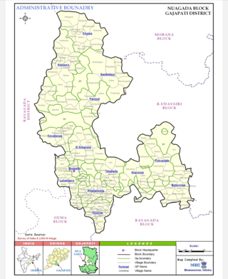
Nuagada is a village and Community Development Block in the Gajapati District of Odisha state in India. The Block comes under the administrative control of Serango and R.Udayagiri Police station. The Block had a population of 57,027 in 2020 census. Mohana is its Vidhan Sabha constituency. This constituency includes Mohana block, R.Udayagiri block, Nuagada block and Rayagada block.

