Related Research Articles
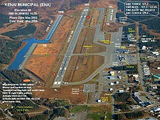
Kenai Municipal Airport is a city-owned, public-use airport located in Kenai, a city in the Kenai Peninsula Borough of the U.S. state of Alaska.
Springdale Municipal Airport is a public use airport in Washington County, Arkansas, United States. It is owned by the City of Springdale and located one nautical mile (2 km) southeast of its central business district. This airport is included in the National Plan of Integrated Airport Systems for 2011–2015, which categorized it as a general aviation facility.

Arlington Municipal Airport is five miles south of Arlington, in Tarrant County, Texas. The airport is at the intersection of Interstate 20 and South Collins Road; it is a reliever airport for Dallas/Fort Worth International Airport and Dallas Love Field.
Baker City Municipal Airport is three miles north of Baker City, in Baker County, Oregon, United States. The National Plan of Integrated Airport Systems for 2011–2015 categorized it as a general aviation facility.

Hermiston Municipal Airport is a city-owned, public-use airport located two nautical miles (3.7 km) southeast of the central business district of Hermiston, in Umatilla County, Oregon, United States.
Elkhart Municipal Airport is a city-owned public-use airport located three nautical miles (6 km) northwest of the central business district of Elkhart, a city in Elkhart County, Indiana, United States.
Atlantic Municipal Airport, is a city-owned public-use airport located two miles (3 km) west of the central business district of Atlantic, a city in Cass County, Iowa, United States. The airport has a runway opened in 2006 capable of handling light business jets.
Monroe County Airport is a county-owned, public-use airport located two nautical miles northwest of the central business district of Madisonville, a town in Monroe County, Tennessee, United States.

Wetumpka Municipal Airport is a city-owned, public-use airport located six nautical miles west of the central business district of Wetumpka, a city in Elmore County, Alabama, United States. It is included in the FAA's National Plan of Integrated Airport Systems for 2011–2015, which categorized it as a general aviation facility. During World War II the airport, known then as Elmore Auxiliary Field, served as an auxiliary field for Gunter Army Airfield training operations. In 2013 the airport was listed in the Alabama Register of Landmarks and Heritage.

Lanett Municipal Airport is a city-owned public-use airport located three nautical miles southwest of the central business district of Lanett, a city in Chambers County, Alabama, United States. According to the FAA's National Plan of Integrated Airport Systems for 2009–2013, it is categorized as a general aviation facility.

Scottsboro Municipal Airport, also known as Word Field, is a city-owned public-use airport located two nautical miles (3.7 km) northeast of the central business district of Scottsboro, a city in Jackson County, Alabama, United States. According to the FAA's National Plan of Integrated Airport Systems for 2009–2013, it is categorized as a general aviation facility.

Waupaca Municipal Airport is a city owned public use airport located three nautical miles (6 km) southeast of the central business district of Waupaca, a city in Waupaca County, Wisconsin, United States. The airport is also known as Brunner Field, which opened in November 1944. It is located adjacent to U.S. Route 10. It is included in the Federal Aviation Administration (FAA) National Plan of Integrated Airport Systems for 2021–2025, in which it is categorized as a local general aviation facility.

Big Sandy Regional Airport is a public use airport in southwest Martin County, Kentucky. The airport is ten miles (17 km) northeast of Prestonsburg, a city in Floyd County.
Deer Park Airport, formerly known as Deer Park Municipal Airport, is a city-owned public-use airport located three nautical miles (6 km) northeast of the central business district of Deer Park, a city in Spokane County, Washington, United States.
Arthur N. Neu Airport is a public airport five miles southeast of Carroll, in Carroll County, Iowa. Also known as Arthur N. Neu Municipal Airport, it was established at its current location in the 1940s.
Glasgow Municipal Airport is a public use airport located two nautical miles (3.7 km) northwest of the central business district of Glasgow, a city in Barren County, Kentucky, United States. It is owned by the Glasgow Airport Board.
Fairmont Municipal Airport is a city-owned public-use airport located two nautical miles (3.7 km) southeast of the central business district of Fairmont, a city in Martin County, Minnesota, United States.
Searcy Municipal Airport is a city-owned public-use airport located three nautical miles south of the central business district of Searcy, in White County, Arkansas, United States.
Madisonville Municipal Airport is a city-owned, public-use airport located three nautical miles (6 km) southwest of the central business district of Madisonville, a city in Madison County, Texas, United States.
Middlesboro–Bell County Airport, is a city-owned public-use airport located 1 mile (1.6 km) west of the central business district of Middlesboro, a city in Bell County, Kentucky, United States.