
Maghull is a town and civil parish in Sefton, Merseyside. The town is north of Liverpool and west of Kirkby. The area also contains Ashworth Hospital.

The West Derby Hundred is one of the six subdivisions of the historic county of Lancashire, in northern England. Its name alludes to its judicial centre being the township of West Derby.

Aintree Racecourse is a racecourse in Aintree, Metropolitan Borough of Sefton, Merseyside, England, bordering the city of Liverpool. The racecourse is the venue for the Grand National steeplechase, which takes place annually in April over three days. Aintree also holds meetings in May and June, October (Sunday), November and December.

Lydiate is a village and civil parish in the Metropolitan Borough of Sefton on Merseyside, England but historically in Lancashire. It is located 1.5 miles (2 km) north of Maghull, with which it has a common history. At the 2001 Census the civil parish of Lydiate had a population of 6,672, reducing to 6,308 at the 2011 Census.

Sefton is a village and civil parish in the Metropolitan Borough of Sefton in Merseyside, England. Located to the south west of Maghull and to the north east of Great Crosby, it is on the flood plain of the River Alt. The village is bisected by the B5422, Brickwall Lane, which cuts also through the site of the moat of Sefton Old Hall, a recognised National Monument. At the 2001 Census the population was recorded as 772, increasing to 855 at the 2011 Census.

The Pawcatuck River is a river in the US states of Rhode Island and Connecticut flowing approximately 34 miles (55 km). There are eight dams along the river's length. USS Pawcatuck was named after the river.

Lunt is a small village in the borough of Sefton in Merseyside, England, close to Sefton Village and to the west of Maghull and is in the L29 postcode.

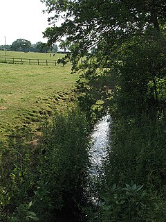
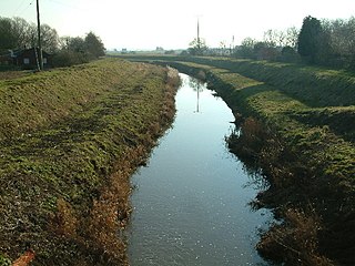
The River Alt is an urban river that flows across Merseyside in England. The river has suffered from heavy pollution from industry and sewage upstream and run-off from farmland in its lower reaches. It empties into the River Mersey, near to where the Mersey itself flows into the Irish Sea. The river has benefited from clean-up schemes and a de-culverting process to improve its water quality and provide a better environment for wildlife.
Knowsley North and Sefton East was a county constituency represented in the House of Commons of the Parliament of the United Kingdom. It elected one Member of Parliament (MP) by the first past the post system of election.

Sefton Central is a constituency represented by Bill Esterson of the Labour Party since 2010.
West Lancashire was a rural district from 1894 to 1974 in Lancashire, England. It was created with other rural districts in 1894, based on the Ormskirk rural sanitary district. It was expanded in 1932 by the abolition of the Sefton Rural District.

Ormskirk was a county constituency represented in the House of Commons of the Parliament of the United Kingdom. It elected one Member of Parliament (MP) by the first past the post system of election. It was created by the Redistribution of Seats Act 1885 as a division of the parliamentary county of Lancashire. The constituency boundaries were changed in 1918, 1950, 1955 and 1974.

The Meers Brook is a stream in Sheffield, England and one of the main tributaries of the River Sheaf. The Meers Brook originates in Gleadless and flows downhill through Gleadless Valley and Meersbrook then, culverted, continues underneath Heeley to pour into the River Sheaf near Saxon Road and Clyde Road in Lowfield.
The Southport & Cheshire Lines Extension Railway was an early British railway company operating in the then county of Lancashire. It was constructed to link the Cheshire Lines Committee railway at Aintree to Southport. It operated from 1884 to 1952.

Ombersley is a village and civil parish in Wychavon district, in the county of Worcestershire, England. The parish includes the hamlet of Holt Fleet, where Telford's 1828 Holt Fleet Bridge crosses the River Severn. The 2011 census recorded a population of 2,360 for the parish.
The River Croco is a small river in Cheshire in England. It starts as lowland field drainage west of Congleton, flows along the south edge of Holmes Chapel, and joins the River Dane at Middlewich. It is about 8 miles (13 km) long.
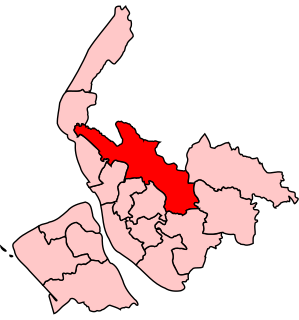
Park is a Metropolitan Borough of Sefton ward in the Sefton Central Parliamentary constituency that covers the villages of Sefton, Lunt, Lydiate and the western part of the town of Maghull, England.
Branston and Mere is a civil parish in the North Kesteven district of Lincolnshire, England. It is situated some 4 miles (6 km) roughly south-east from the city and county town of Lincoln. The parish is a long strip between the RAF Waddington airfield and the River Witham near Bardney. The A15 road crosses the extreme west and the parish is bisected by the Sleaford to Lincoln railway line The civil parish was created in 1931, by merging the two former parishes of Branston and Mere.
Downholland Brook is a 4.3-kilometre-long (2.7 mi) river (brook) in Merseyside, England, that is a tributary to the River Alt in the Alt catchment. Rising from Barton Brook in the Metropolitan Borough of Knowsley, the river flows a westerly course until reaching Moss Side, when it turns north towards Little Altcar in the Metropolitan Borough of Sefton. There, it flows into the River Alt.

Simonswood Brook is a minor, 12-kilometre-long (7.5 mi) river (brook) in Merseyside, England, that is a tributary to the River Alt in the Alt catchment. As the stream enters Kirkby, it is known as the Kirkby Brook.
