Oak Island is a privately owned island in Lunenburg County on the south shore of Nova Scotia, Canada. The tree-covered island is one of several islands in Mahone Bay, and is connected to the mainland by a causeway. The nearest community is the rural community of Western Shore which faces the island, while the nearest village is Chester. The island is best known for various theories about buried treasure or historical artifacts, and the associated attempts to explore the site.
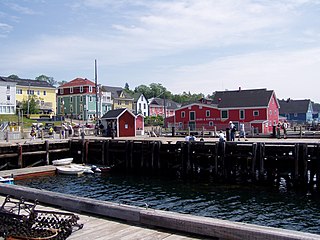
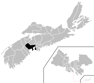
Lunenburg County is a historical county and census division on the South Shore of the Canadian province of Nova Scotia. Major settlements include Bridgewater, Lunenburg, and Mahone Bay.

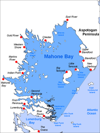
Mahone Bay is a town on the northwest shore of Mahone Bay along the South Shore of Nova Scotia in Lunenburg County. A long-standing picturesque tourism destination, the town has recently enjoyed a growing reputation as a haven for entrepreneurs and business startups. The town has the fastest growing population of any municipality in Nova Scotia according to the 2016 census, experiencing 9.9% population growth.
Rockbound is a novel published in 1928 by Canadian writer Frank Parker Day.

St. Margarets Bay is a bay located on the Atlantic coast of Nova Scotia, Canada on the border of Halifax County and Lunenburg County.
Lunenburg is a provincial electoral district in Nova Scotia, Canada, that elects one member of the Nova Scotia House of Assembly.
Chester—St. Margaret's is a provincial electoral district in Nova Scotia, Canada, that elects one member of the Nova Scotia House of Assembly. It is located on the South Shore.
The Aspotogan Peninsula is a peninsula in the eastern part of Lunenburg County, Nova Scotia, separating St. Margarets Bay in the east from Mahone Bay in the west. The peninsula was originally settled by second generation French immigrants on the east side and by second generation German immigrants on the west side. Traditionally fishing was a major industry for communities throughout the peninsula, however other primary industries such as farming and forestry were historically important as well. Shipping and shipbuilding were secondary and tertiary industries that also came into prominence during the 19th and early 20th centuries.

Nova Scotia Trunk 3 is an east-west trunk highway in Nova Scotia. The route runs from Halifax to Yarmouth, along the South Shore. Trunk 3's status as an important regional highway link has been superseded by the parallel Highway 103.

The South Shore Regional Centre for Education (SSRCE) is the public school board responsible for the administration of elementary, junior high, and high school education in Lunenburg County and Queens County in Nova Scotia, Canada. The South Shore Regional Centre for Education was established on April 1, 2018 by the Nova Scotia Education Reform Act. It replaced the South Shore Regional School Board which was created August 1, 2004 by an Act of the provincial legislature.
The Lighthouse Route is a scenic roadway in the Canadian province of Nova Scotia. It follows the province's South Shore for 585 km (364 mi) from Halifax to Yarmouth.

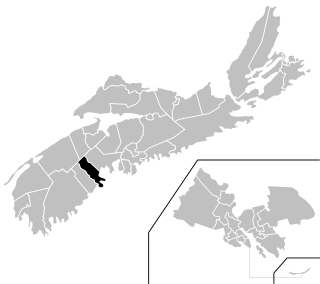
The Municipality of the District of Chester is a Nova Scotia district municipality occupying the northeastern half of Lunenburg County, Canada.
Forest Heights Community School is a high school located in Chester Basin, Nova Scotia, Canada. Servicing students and families from eastern Lunenburg County, it is a member school of the South Shore Regional School Board.
Blandford is a community in the Canadian province of Nova Scotia, located in the Chester Municipal District on the Aspotogan Peninsula on the Lighthouse Route. Blandford originally included the present day communities of New Harbour, Upper Blandford, and Deep Cove.
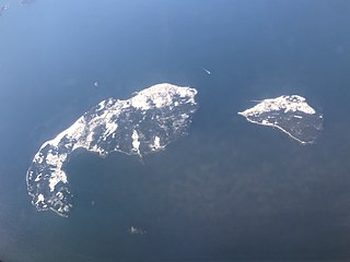
Little Tancook Island is a Canadian island located off the coast of Nova Scotia. The island is one of the 365 islands dotting Mahone Bay. The island is 1.5 km (0.93 mi) long by 1 km (0.62 mi) wide and is roughly triangular in shape. It is separated from Big Tancook Island by the 1 km (0.62 mi) wide strait called "The Chops." It is located approximately 2 km (1.2 mi) off the Aspotogan Peninsula.
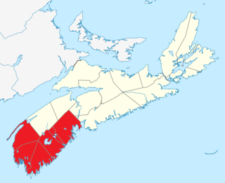
Southern Nova Scotia or the South Shore is a region of Nova Scotia, Canada. The area has no formal identity and is variously defined by geographic, county and other political boundaries. Statistics Canada, defines Southern Nova Scotia as an economic region, composed of Lunenburg County, Queens County, Shelburne County, Yarmouth County, and Digby County. According to Statistics Canada, the region had the highest decrease of population in Canada from 2009 to 2010, with a population decrease of 10.2 residents per thousand. The region also has the second-highest median age in Canada at 47.1 years old.
East Ironbound is an inhabited island located off the Aspotogan Peninsula in Lunenburg County, Nova Scotia, between St. Margarets Bay and Mahone Bay.

The following outline is provided as an overview of and topical guide to Nova Scotia:
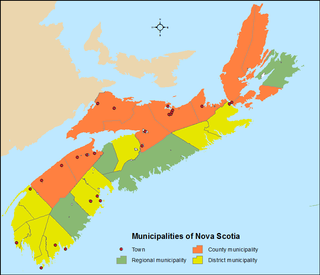
The Canadian province of Nova Scotia is divided into 49 municipalities, of which there are three types: regional (4), town (25), and county or district municipality (20).