
The City of Warrnambool is a local government area in the Barwon South West region of Victoria, Australia, located in the south-western part of the state. It covers an area of 121 square kilometres (47 sq mi) and in June 2018 had a population of 34,862. It is entirely surrounded by the Shire of Moyne and the Southern Ocean. It is one of only a few regional councils in Victoria to remain serving just one urban district after the amalgamation process of 1994, although through that process it did gained some portions of the former Shire of Warrnambool.

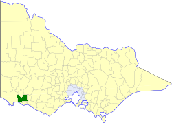
The Shire of Moyne is a local government area in the Barwon South West region of Victoria, Australia, located in the south-western part of the state. It covers an area of 5,481 square kilometres (2,116 sq mi) and in June 2018 had a population of 16,887. It includes the towns of Port Fairy, Koroit, Mortlake, Macarthur, Peterborough, Caramut, Ellerslie, Framlingham, Garvoc, Hawkesdale, Kirkstall, Panmure, Mailors Flat, Purnim, Wangoom and Woolsthorpe. It also entirely surrounds the City of Warrnambool, a separate local government area. It was formed in 1994 from the amalgamation of the Shire of Belfast, Shire of Minhamite, Borough of Port Fairy, and parts of the Shire of Mortlake, Shire of Warrnambool, Shire of Dundas, Shire of Mount Rouse and Shire of Hampden.

Port Fairy is a coastal town in south-western Victoria, Australia. It lies on the Princes Highway in the Shire of Moyne, 28 kilometres (17 mi) west of Warrnambool and 290 kilometres (180 mi) west of Melbourne, at the point where the Moyne River enters the Southern Ocean.

Mortlake is a town in the Western District of Victoria, Australia on the Hamilton Highway, 50 kilometres (31 mi) north-east of Warrnambool. It is in the Shire of Moyne local government area and the federal Division of Wannon. At the 2001 census, Mortlake had a population of 941, rising to 996 in 2006, and to 1,073 in 2011.

Koroit is a small rural town in western Victoria, Australia a few kilometres north of the Princes Highway, 18 kilometres (11 mi) north-west of Warrnambool and 278 kilometres (173 mi) west of Melbourne. It is in the Shire of Moyne local government area located amidst rolling green pastures on the north rim of Tower Hill. At the 2016 census, Koroit had a population of 2,055. The town borrows its name from the Koroitch Gundidj people who occupied the area prior to European colonisation.

Dongara is a town 351 kilometres (218 mi) north-northwest of Perth, Western Australia on the Brand Highway. The town is located at the mouth of the Irwin River. The area is marketed as the 'Rock lobster capital of Australia'.
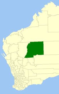
The Shire of Wiluna is a local government area in the Mid West region of Western Australia, about 950 kilometres (590 mi) northeast of the state capital, Perth. The Shire covers an area of 182,155 square kilometres (70,330 sq mi), and its seat of government is the town of Wiluna.

The Shire of Belfast was a local government area about 290 kilometres (180 mi) west-southwest of Melbourne, the state capital of Victoria, Australia. The shire covered an area of 5,190 square kilometres (2,003.9 sq mi), and existed from 1853 until 1994.
The Shire of Minhamite was a local government area located about 270 kilometres (168 mi) west of Melbourne, the state capital of Victoria, Australia. The shire covered an area of 1,365.62 square kilometres (527.3 sq mi), and existed from 1871 until 1994.

The Shire of Mortlake was a local government area about 220 kilometres (137 mi) west of Melbourne, the state capital of Victoria, Australia. The shire covered an area of 2,137 square kilometres (825.1 sq mi), and existed from 1860 until 1994.

The Shire of Warrnambool was a local government area located about 260 kilometres (162 mi) west-southwest of Melbourne, the state capital of Victoria, Australia. The shire covered an area of 1,605 square kilometres (619.7 sq mi), and existed from 1854 until 1994.

The Borough of Port Fairy was a local government area about 290 kilometres (180 mi) west-southwest of Melbourne, the state capital of Victoria, Australia. The borough covered an area of 22.72 square kilometres (8.8 sq mi), and existed from 1856 until 1994. Its area was surrounded by the Shire of Belfast and the Southern Ocean.

Hawkesdale is a town in the Western District of Victoria, Australia on the Penshurst-Warrnambool Road. It is in the Shire of Moyne local government area and the federal Division of Wannon. At the 2016 census, Hawkesdale and the surrounding area had a population of 322.
Caramut is a town in the Western District of Victoria, Australia on the Hamilton Highway. It is in the Shire of Moyne local government area and the federal Division of Wannon.

Garvoc is a town in the Western District of Victoria, Australia. The town is located in the Moyne Shire local government area, 223 kilometres (139 mi) south west of the state capital, Melbourne.

Griffiths Island, sometimes incorrectly spelled as Griffith Island or Griffitts Island, lies at the mouth of the Moyne River next to, and within the bounds of, the town of Port Fairy, in the Western District of the state of Victoria in Australia. Griffiths now has no permanent inhabitants, but is connected to the mainland by a causeway and is accessible on foot. It forms part of the Port Fairy and Belfast Coastline Protection Reserve and, as well as being a tourist attraction, is an important site in the context of the history of European settlement of western Victoria. It is managed by the Moyne Shire Council.

The Barwon South West is an economic rural region located in the southwestern part of Victoria, Australia. The Barwon South West region stretches from the tip of the Queenscliff Heads to the border of South Australia. It is home to Victoria’s largest provincial centre, Geelong and the major centres of Aireys Inlet, Apollo Bay, Camperdown, Colac, Hamilton, Lorne, Port Campbell, Port Fairy, Portland, Torquay and Warrnambool. It draws its name from the Barwon River and the geographic location of the region in the state of Victoria.
James Desmond Purcell is an Australian politician. He was a Vote 1 Local Jobs member of the Victorian Legislative Council, having represented Western Victoria Region from 2014 to 2018.
Australian Community Media & Printing (ACM) is a trading name of Rural Press Limited, a media company in Australia responsible for over 160 regional publications. Its mastheads include The Canberra Times, The Newcastle Herald, The Examiner, The Border Mail, The Courier and the Illawarra Mercury along with more than one hundred community-based websites across Australia and numerous agricultural publications including The Land and Queensland Country Life.
Winslow is a locality in western Victoria, Australia. It is in the Shire of Moyne local government area, in what is commonly known as the Western District. Winslow is 17 km north of Warrnambool. It is believed that it was named after Winslow in Buckinghamshire, England.
