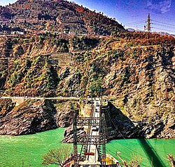
Maitra | |
---|---|
Coordinates: 33°14′N75°14′E / 33.23°N 75.23°E | |
Country | India |
Union Territory | Jammu and Kashmir |
District | Ramban |
Languages | |
• Spoken | Pogali, Urdu |
Time zone | UTC+5:30 (IST) |
PIN | 182144 [1] |
Maitra is a village, near Ramban town in Ramban district in the Indian union territory of Jammu and Kashmir. [2]
Doda district is an administrative district of the Jammu division of Indian-administered Jammu and Kashmir in the disputed Kashmir region.
Batote is a town and a notified area committee, near Ramban town in Ramban district of Indian union territory of Jammu and Kashmir on NH 44 just beyond Ramban, Patnitop while going towards Srinagar.
Ramban is a town in Ramban district of Jammu and Kashmir, India, which is the district headquarters of Ramban district. It lies on the banks of the Chenab river in Chenab Valley on the National Highway-1A at about 120 km from Jammu and about 130 km from Srinagar, making it almost the central point on the Jammu-Srinagar National Highway.
Ramban district is an administrative district in the Jammu division of Indian-administered Jammu and Kashmir in the disputed Kashmir region. It is located in a valley surrounded the Pir Panjal range. It was carved out as a separate district from erstwhile Doda district in 2007. It is located in the Jammu division. The district headquarters are at Ramban town, which is located midway between Jammu and Srinagar along the Chenab river in the Chenab valley on National Highway-44, approximately 151 km from Jammu and Srinagar.
Udhampur Lok Sabha constituency is one of the six Lok Sabha (parliamentary) constituencies in Jammu and Kashmir in northern India. The constituency covers 20,230 square kilometres of mountainous Himalayan terrain, and is comparable to the size of Israel. It is composed of the districts of Kishtwar, Ramban, Kathua, Doda, Reasi, and Udhampur. Udhampur constituency's population is over 2,400,000, and exceeds the population of New Mexico. The seat from 1967-1980 was held by Karan Singh, the former crown prince of Jammu and Kashmir.
Chenab Valley used to refer to parts of the Indian-administered Union Territory of Jammu and Kashmir, specifically the present-day districts of Doda, Kishtwar, Ramban. These three districts used to be part of a single former district called Doda, which was created in 1948 out of the eastern parts of Udhampur district of the princely state of Jammu and Kashmir, and are sometimes collectively referred to as the Doda belt. The term is used to refer these area which are culturally and linguistically very much different from rest Jammu Division.
Shangus is an assembly constituency and a tehsil in Anantnag district of the Indian union territory of Jammu and Kashmir. It is the biggest village in Anantnag District in terms of Population and area. Jamia Masjid Shangus popular as Masjid e Mukaram is the 2nd largest Masjid in J&K after Jamia Masjid, Srinagar.The old Jama Masjid shangus was the third-largest mosque in Kashmir,after Srinagar and shopian built on the pattern of Srinagar and Shopian Jamia Masjids. It was heavily influenced by Persian architecture and has a square garden in the middle. The construction of the mosque started on November 9, 1949, and was completed in 1955, taking around 6 years at that time. According to ancestors, when the fundraising began, it was around 300 rupee first time & then money for the construction of the mosque was collected from the whole area, totaling 18,000 rupees at that time during the inaugural construction. Later, it was upgraded and decorated over time to time In 2020, it was decided that reconstruction should take place by the local body of auqaf but it took some time because of COVID that time .The reconstruction started with a stone-laying ceremony on August 13, 2021, and is continuing to this date. Its area was increased from two sides, making it the second-largest mosque in all of Kashmir after Historic Srinagar jamia masjid & taking over shopian mosque. If you want to visit, you can simply reach Shangus via Achabal or, which is just 6-7 km away or through mattan side u can also reach shangus.It is located on the road leading to Anantnag East (Islamabad) areas like Wangam, Isso, Ranipora,brah telwani etc.The auqaf building is just adjacent to jamia masjid.{Note:Whoever has edited before please provide the correct info-SIA}
Sangaldan is a town near Ramban town in the Ramban district of the Indian union territory of Jammu and Kashmir. It falls in the Gool-Gulabgarh area of the Chenab valley.
The Jammu division is a revenue and administrative division of the Indian-administered Jammu and Kashmir in the disputed Kashmir region. It is bordered by the Kashmir division to the north. It consists of the districts of Jammu, Doda, Kathua, Ramban, Reasi, Kishtwar, Poonch, Rajouri, Udhampur and Samba. Most of the land is hilly or mountainous, including the Pir Panjal Range which separates it from the Kashmir Valley and part of the Great Himalayas in the eastern districts of Doda and Kishtwar. Its principal river is the Chenab.
Banihal railway station, a part of Jammu–Baramulla line, is situated in notified area of Banihal in Ramban district, Jammu and Kashmir. It was commissioned on 26 June 2013 and passenger trains run from Banihal to Qazigund. The station was inaugurated by former prime minister Manmohan Singh and UPA Chairperson Sonia Gandhi on the same day at 2.22 pm. They enjoyed the 12-minute ride in train through Pir Panjal tunnel up to Qazigund with 100 students, mostly girls, of the Banihal Higher Secondary School, and made the 17.8-km ride back to Banihal, passing through the tunnel again, the second longest in Asia.
Sangaldan Railway Station is a railway station in Ramban district, Jammu and Kashmir. Its code is SGDN. It serves Sangaldan block, Gool Sub-division and Ramban District. The station has three platforms. The station lies on Banihal–Katra line. The Work on this rail line upto Sangaldan has been completed in February 2024. The station in surrounded by many of long tunnels of Jammu–Baramulla line.
Ashok Kumar was a Member of the Jammu and Kashmir Legislative Assembly for Ramban. He was elected in the 2008 Jammu and Kashmir Legislative Assembly election and served one term. His political party is the Indian National Congress.
Gool Valley is a town in Ramban district of Jammu and Kashmir, India.
Ramsoo is a village and municipality in Ramban district of the Indian union territory of Jammu and Kashmir. The town is located 22 kilometres from the district headquarters Ramban.
Saraz or Siraj is a hilly region in the eastern part of the Jammu division of Jammu and Kashmir in northern India. Historically a pargana within the erstwhile state of Kishtwar, the region currently takes up the northern half of Doda district and parts of neighbouring Ramban and Kishtwar districts. Its population in 2011 stood at 180,000 people. The region is defined mainly on the basis of linguistics where the majority of people speak Sarazi as their mother tongue.
Ramban Assembly constituency is one of the 90 constituencies in the Jammu and Kashmir Legislative Assembly of Jammu and Kashmir a north state of India. Ramban is also part of Udhampur Lok Sabha constituency.
Rajgarh is a village and tehsil located in the Ramban district of the Indian-administered union territory of Jammu and Kashmir. It is situated approximately 23 kilometers away from the nearest town, Ramban.
Digdole is a village located in the Ramban district of the Indian-administered union territory of Jammu and Kashmir. It is situated approximately 10 kilometers away from the district headquarters of Ramban.
Neelam Kumar Langeh is an Indian politician from Jammu and Kashmir. He is an MLA from Ramban Assembly constituency which is reserved for Scheduled Caste community in Ramban district. He won the 2014 Jammu and Kashmir Legislative Assembly election representing the Bharatiya Janata Party. He was dropped from the seat in the 2024 Assembly election by the BJP.