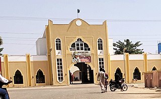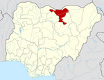
Jigawa State (Hausa: Jihar Jigawa is one of the 36 states of Nigeria, located in the northern region of the country. Created on August 27, 1991, under the General Ibrahim Babangida who announced the creation of nine additional states in the country bringing the total number of states then to thirty. The announcement was given a legal backing through the; State Creation and Transitional Provisions Decree No. 37 of 1991. Jigawa State is located in the northeastern-most region of Kano State, and shares border with Nigeria's national border with the Republic of the Niger. The state capital and largest city is Dutse. Jigawa state has 27 local governments
The city of Gusau, located in northwestern Nigeria, is the capital of Zamfara State. It is also the name of the state's Local Government Area (LGA), which has an area of 3,364 km (2,090 mi)² and a population of 383,162 as of the 2006 census.

Gumel or Gumal is a city and traditional emirate in Jigawa State, Nigeria.
Haɗejiya is a Hausa town in eastern Jigawa State, northern Nigeria. The population was approximately 105,628 in 2006. Hadejia lies between latitude 12.4506N and longitude 10.0404E. It shared boundary with Kiri Kasama Local Government from the East, Mallam Maɗori Local Government from the North, and Auyo Local Government from the West. The Hadejia Local Government consist of eleven (11) political wards namely: Atafi, Dubantu, Gagulmari, Kasuwar Ƙofa, Kasuwar Kuda, Matsaro, Majema, Rumfa, Sabon Garu, Ƴankoli and Yayari. Inhabitant are dominantly Hausa, Fulani and Kanuri with some other groups such as Tiv, Yoruba, Igbo, Igala etc. The dominant occupation of the inhabitants is crop farming and animal rearing which a considerable percentage, engaged in trading, fishing and services including civil service. The people of Haɗeja are largely Muslims, although some follow indigenous belief systems. The town lies to the north of the Hadejia River, and is upstream from the Hadejia-Nguru wetlands. Hadejia is an internationally important ecological and sensitive zone.

Ningi is a town, a local government area, and an emirate in Bauchi State, Nigeria. The Ningi emirate comprises two local government areas, Ningi and Warji, with a combined area of 5,250 km2 and a population of 501,912 according to the 2006 Census. The Ningi local government area covers an area of 4,625 km2 with a population of 387,192 at the 2006 Census. The area is inhabited mostly by hausa people, Duwa, Ningawa.Yunusa Muhammadu Danyaya is the current Emir of Ningi.

Katagum is a town, a local government area and a traditional emirate in Bauchi State of north eastern Nigeria. The town is located on the northern bank of the Jama'are River, which is a tributary of the Hadejia. Most of the inhabitants are peoples from the Fulani and Kanuri tribes. The chief agricultural products include peanuts (groundnuts), sorghum, millet, rice, cowpeas, cotton, indigo, and gum arabic. Livestock include horses, cattle, goats, sheep, donkeys and a lot of poultry.

Nigeria has 774 local government areas (LGAs), each administered by a local government council consisting of a chairman, who is the chief executive, and other elected members, who are referred to as councillors. Each LGA is further subdivided into a minimum of ten and a maximum of twenty wards. A ward is administered to by a councillor, who reports directly to the LGA chairman. The councillors fall under the legislative arm of the local government, the third tier of government in Nigeria, below the state governments and the federal government.

Ukwa West is a Local Government Area in Abia State, Nigeria. Its headquarters is in the town of Oke Ikpe.

Jama'are is a Local Government Area of Bauchi State, Nigeria. Its headquarters are in the town of Jama'are. It has an area of 493 km2 and a population of 176,883 at the 2006 census. The postal code of the area is 751. It is populated by a Fulani tribe that migrated from Dulare in the Lake Chad basin in the Republic of Chad.

Buruku is a Local Government Area of Benue State, Nigeria. Its headquarters are in the town of Buruku.
Danja is a Local Government Area in Katsina State, Nigeria. Its headquarters are in the town of Danja.
Karaye is a Local Government Area and Headquarter of Karaye Emirate Council in Kano State, Nigeria. Its headquarters are in the town of Karaye.
Shanono is a Local Government Area in Kano State, Nigeria. It is the headquarter of Shanono local government.
Rano is a Local Government Area and headquarters of Rano Emirate council in Kano State, Nigeria. Rano is a local government area in Kano State with administrative headquarters in the town of Rano. Rano local government area is a Hausa-Fulani community in the southern senatorial district of Kano State otherwise known as Kano South Senatorial District alongside Albasu, Bebeji, Bunkure, Doguwa, Gaya, Kiru, Takai, Ajingi, Rogo, Kibiya, Tudun Wada, Garko, Wudil and Sumaila local government areas. Rano local government area also forms a federal constituency alongside Bunkure and Kibiya local government areas. It has an area of 520 km2 and a population of 145,439 at the 2006 census. The local government area is bounded to the north by Garun Mallam and Bunkure local government areas, to the east by Kibiya local government area, to the south by Tudun Wada local government area, and to the west by Bebeji local government area. The Rano local government council is in charge of public administration in Rano local government area. The council is led by a chairman who is the executive head of the local government. The Rano legislative council make laws governing Rano local government area. It consists of 10 Councillors representing the 10 wards of the local government area.
Bunkure is a Local Government Area in Kano State, Nigeria. Its headquarters are in the town of Bunkure.
Garun Mallam is a Local Government Area in Kano State, Nigeria. Its headquarters are in the town of Garun Mallam on the A2 highway.
Sanga is a Local Government Area in southern Kaduna State, Nigeria. Its headquarters is in the town of Gbantu. The Local Government Council is chaired by Bisallah Malam. It has an area of 1,821 km2 and had a population of 151,485 as at the 2006 census. The postal code of the area is 801.
Lere is a Local Government Area and town in southern Kaduna State of Nigeria. Lere town is located geographically at the latitude 10 degrees 39 North and longitude 8 degrees 57 East. It is the headquarters of the Lere Emirate. The town and its environs has an estimated population of about 93,290 (2016). Lere Local Government has an area of 2,634 km2 and a population of 339,740 at the 2006 census. Its headquarters are in the town of Saminaka. The postal code of the area is 811.
Qua'an Pan is a Local Government Area in Plateau State, Nigeria. Its headquarters are in the town of Baap.

The 2023 Nigerian Senate elections in Jigawa State will be held on 25 February 2023, to elect the 3 federal Senators from Jigawa State, one from each of the state's three senatorial districts. The elections will coincide with the 2023 presidential election, as well as other elections to the Senate and elections to the House of Representatives; with state elections being held two weeks later. Primaries were held between 4 April and 9 June 2022.
[[Usman Aliyu Mallam Madori.


