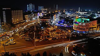
Bhopal is the capital city of the Indian state of Madhya Pradesh and the administrative headquarters of both Bhopal district and Bhopal division. It is known as the City of Lakes for its various natural and artificial lakes and for being one of the greenest cities in India. It is the 16th largest city in India and 131st in the world. After formation of Madhya Pradesh, the state capital Bhopal was a part of the Sehore district. It was bifurcated in 1972 and a new district Bhopal was formed. Flourishing around 1707, the city was the capital of the former Bhopal State, a princely state of the British ruled by the Nawabs of Bhopal. Numerous heritage structures from this period include the Taj-ul-Masajid and Taj Mahal palace. In 1984, the city was struck by the Bhopal disaster, one of the worst industrial disasters in history.

Gwalior is a major city in the central Indian state of Madhya Pradesh lies at upper Madhya Pradesh and one of the Counter-magnet cities. Located 343 kilometres (213 mi) south of Delhi, the capital city of India, 120 kilometres (75 mi) from Agra and 414 kilometres (257 mi) from Bhopal, the state capital, Gwalior occupies a strategic location in the Gird region of India. The historic city and its fortress have been ruled by several historic northern Indian kingdoms. From the Kachchhapaghatas in the 10th century, Tomars in the 13th century, it was passed on to the Mughal Empire, then to the Maratha in 1754, followed by the Scindia in the 18th century. In April 2021, It was found that Gwalior had the best air quality index amongst the 4 major cities in Madhya Pradesh

Bhind district is a district in the Chambal division of the Indian state of Madhya Pradesh. The town of Bhind is the district headquarters. Bhind District is situated in Chambal region in the northwest of the state. It is bounded by Agra, Etawah, Jalaun and Jhansi districts of Uttar Pradesh state to the north and the east, and the Madhya Pradesh districts of Datia to the south, Gwalior to the southwest, and Morena to the west. The geography of the district is characterised by uneven ravines, plain fertile fields and scanty forests. The total area of the district is 4,459 km2 (1,722 sq mi).

Bhitarwar is a city and a Municipality in Gwalior district in the state of Madhya Pradesh, India. The town is surrounded by a river called Parbati.

Bijaipur is a town and municipality in the Sheopur district in the state of Madhya Pradesh, India. It is located on the bank of the Kwari River. It is the headquarters of Bijeypur (Vijaypur) Tehsil and Vijaypur. The town is one of the gateways to the Kuno Wildlife Sanctuary, the site selected as a second home to the Asiatic Lion and also for cheetah reintroduction in India.

Chirgaon is a town and a municipal board in Jhansi district in the Indian state of Uttar Pradesh, India.
Lahar is a town and a Nagar Panchayat in Bhind district in the Indian state of Madhya Pradesh.
Mandideep is a town with municipality in Goharganj sub-district of Raisen district in the Indian state of Madhya Pradesh. Mandideep is 23 km from Bhopal and is basically an Industrial township which came into existence in late 1970s. The Mandideep Municipality has population of 59,654 of which 32,390 are males while 27,264 are females as per report released by 2011 Census of India. Literacy rate of Mandideep city is 83.76 % higher than state average of 69.32 %. In Mandideep, Male literacy is around 89.33 % while female literacy rate is 77.04. Mandideep's annual productions are worth some Rs. 80,000 crore in 2021, making it one of the most productive economic centers in India.
Raghogarh-Ruthiyai is a municipality and Raghogarh-Ruthiyai a town in Guna district in the Indian state of Madhya Pradesh.

Dabra is town and a municipality in Gwalior district in the state of Madhya Pradesh, India located near NH-75 national highway. It serves the headquarters for both a tehsil and a coterminous community development block.
The Delhi–Mumbai Industrial Corridor Project (DMIC) is a planned industrial development project between India's capital, Delhi and its financial hub, Mumbai. The DMIC project was launched in pursuance of an MOU signed between the Government of India and the Government of Japan in December 2006. It is one of the world's largest infrastructure projects with an estimated investment of US$90 billion and is planned as a high-tech industrial zone spread across Six Indian States, as well as Delhi, the national capital and itself a Union Territory. The investments will be spread across the 1,500 km long Western Dedicated Freight Corridor which will serve as the industrial corridor's transportation backbone.
The economy of Madhya Pradesh refers to the economic growth with respect to the Indian state of Madhya Pradesh. It grew 12% in GDP for the year of 2011–12, for which it received an award from then President Pranab Mukherjee in January 2013 for improving its tourism, medical and infrastructural growth. The economy of Madhya Pradesh is significantly agrarian which is reflecting rapid strides towards industrial and service sectors as well. The Indore,Bhopal and Jabalpur districts are the top 3 districts in the state's larger economy.

Sri City or Satyavedu Reserve Infracity Pvt. Ltd. is an integrated business city (township) located on NH 16 in the state of Andhra Pradesh, India. Much of the Sri City area is in Chittoor District and a smaller area along the NH16 is in Nellore District of Andhra Pradesh, India.
Gwalior Junction railway station is the railway station of Gwalior City, Madhya Pradesh, India. It is operated by Indian Railways and is part of the Jhansi Division of the North-Central Railways.

Birlanagar Junction railway station is a small railway junction in Gwalior city, Madhya Pradesh. Its code is BLNR. It serves Gwalior city. The station consists of three platforms. The platforms are not well sheltered. It lacks many facilities including water and sanitation.
The Ratlam – Gwalior Intercity Express is an intercity train service which runs between Ratlam Junction railway station of Ratlam of Central Indian state of Madhya Pradesh and Gwalior Junction railway station of Gwalior, the important city of the madhya pradesh.
The Gwalior Metro is a proposed rapid transit system to serve Gwalior, Gwalior West and other nearby towns in Gwalior Metropolitan Region in the Indian state of Madhya Pradesh. The project was announced by current state Chief Minister Shivraj Singh Chouhan on 17 October 2014. The survey has been started. It is so far the third metro system proposed in the Indian state of Madhya Pradesh after Indore Metro, and Bhopal Metro.The network consists of three colour-coded regular lines proposed to serve 21 stations with a total length of 58.1 kilometres. The system will have a mix of underground, at-grade, and elevated stations using standard-gauge tracks.
Malanpu railway station is a small railway station in Bhind district, Madhya Pradesh. Its code is MLAR. It serves Industrial Area of Malanpur. The station consists of two platforms. The platforms are not well sheltered. It lacks many facilities including water and sanitation.
Gwalior West is a development project under National Capital Region. It was started in 1992 to attract the population of Delhi. Gwalior was first city out of 5 Counter Magnets selected by the government. Gwalior West lies 15 km from Gwalior and 8 km east of the Tigra Dam.

Bhind railway station is a railway station in Bhind city of Madhya Pradesh. Its code is BIX. It serves Bhind city. The station consists of three platforms. Passenger, Express and Superfast trains halt here.

