Maldive Islands

Last updated
Maldive Islands
Maldives.A2004005.0545.1km.jpg
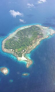
Satellite image of the Maldive Islands
Indian Ocean laea relief location map.jpg
Red pog.svg
Maldive Islands
Geography
Location Indian Ocean
Coordinates 3°12′N73°13′E / 3.20°N 73.22°E / 3.20; 73.22 Coordinates: 3°12′N73°13′E / 3.20°N 73.22°E / 3.20; 73.22
Total islands1190
Administration

The Maldive Islands is a group of islands in the Indian Ocean composing today's Republic of Maldives and the island of Minicoy in the Union Territory of Lakshadweep of India.

Indian Ocean The ocean between Africa, Asia, Australia and Antarctica (or the Southern Ocean)

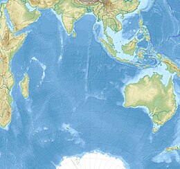
The Indian Ocean is the third-largest of the world's oceanic divisions, covering 70,560,000 km2 (27,240,000 sq mi). It is bounded by Asia on the north, on the west by Africa, on the east by Australia, and on the south by the Southern Ocean or, depending on definition, by Antarctica.

Maldives South Asian country in the Indian Ocean

The Maldives, officially the Republic of Maldives, is a small country in South Asia, located in the Arabian Sea of the Indian Ocean. It lies southwest of Sri Lanka and India, about 1,000 kilometres (620 mi) from the Asian continent. The chain of 26 atolls stretches from Ihavandhippolhu Atoll in the north to Addu Atoll in the south. Comprising a territory spanning roughly 298 square kilometres (115 sq mi), the Maldives is one of the world's most geographically dispersed sovereign states as well as the smallest Asian country by land area and population, with around 427,756 inhabitants. Malé is the capital and the most populated city, traditionally called the "King's Island" for its central location.

Minicoy island

Minicoy, locally known as Maliku is an island in Lakshadweep, India. Along with Viringili, it is on Maliku atoll, the southernmost atoll of Lakshadweep archipelago. Administratively, it is a census town in the Indian union territory of Lakshadweep.

Historically Minicoy was within the domain of the sultans of the Maldives. In 1790 Minicoy was surrendered to the Court of Directors of the East India Company and thus became part of the territory of the Madras presidency of British India. [1] In 1858, following the Indian Mutiny of 1857, the control of British India transferred from the East India Company to the British Crown, and a decade later Queen Victoria was proclaimed empress. [2]

Sultan noble title with several historical meanings

Sultan is a position with several historical meanings. Originally, it was an Arabic abstract noun meaning "strength", "authority", "rulership", derived from the verbal noun سلطة sulṭah, meaning "authority" or "power". Later, it came to be used as the title of certain rulers who claimed almost full sovereignty in practical terms, albeit without claiming the overall caliphate, or to refer to a powerful governor of a province within the caliphate. The adjective form of the word is "sultanic", and the dynasty and lands ruled by a sultan are referred to as a sultanate.

East India Company 16th through 19th-century British trading company

The East India Company (EIC), also known as the Honourable East India Company (HEIC) or the British East India Company, and informally known as John Company, Company Bahadur, or simply The Company, was an English and later British joint-stock company. It was formed to trade in the Indian Ocean region, initially with Mughal India and the East Indies, and later with Qing China. The company ended up seizing control over large parts of the Indian subcontinent, colonised parts of Southeast Asia, and colonised Hong Kong after a war with Qing China.

The Crown is the state in all its aspects within the jurisprudence of the Commonwealth realms and their sub-divisions. Legally ill-defined, the term has different meanings depending on context. It is used to designate the monarch in either a personal capacity, as Head of the Commonwealth, or as the king or queen of his or her realms. It can also refer to the rule of law; however, in common parlance 'The Crown' refers to the functions of government and the civil service.

The Maldive Islands became a British protectorate in 1887. [3] At the time of the partition of India of 1947, Minicoy transferred automatically to the new Union of India, while the remainder of the Maldives continued as a self-governing sultanate, under the status of British protection, ultimately achieving full independence in 1965. [3]

British protectorates were territories over which the British government exercised only limited jurisdiction. Many territories which became British protectorates already had local rulers whom the Crown negotiated with through treaty, acknowledging their status whilst simultaneously offering protection. British protectorates were therefore governed by indirect rule. In most cases, the local ruler, as well as the subjects of the ruler, were not British subjects.

Partition of India partition of British India into the independent states of India and Pakistan in 1947

The Partition of India was the division of British India in 1947 which accompanied the creation of two independent dominions, India and Pakistan. The Dominion of India is today the Republic of India and Dominion of Pakistan, the Islamic Republic of Pakistan and the People's Republic of Bangladesh. The partition involved the division of two provinces, Bengal and the Punjab, based on district-wise Hindu or Muslim majorities. It also involved the division of the British Indian Army, the Royal Indian Navy, the Indian Civil Service, the railways, and the central treasury, between the two new dominions. The partition was set forth in the Indian Independence Act 1947 and resulted in the dissolution of the British Raj, or Crown rule in India. The two self-governing countries of India and Pakistan legally came into existence at midnight on 14–15 August 1947.

Linguistically, Minicoy remains linked to the rest of the island group.

See also

Solomon Islands (archipelago) archipelago

The Solomon Islands are an archipelago in the western South Pacific Ocean, located northeast of Australia. They are in the Melanesia subregion and bioregion of Oceania. The archipelago forms much of the territory of Solomon Islands, while the northwestern islands are within the Autonomous Region of Bougainville, in eastern Papua New Guinea. It forms the eastern boundary of the Solomon Sea.

Bougainville Island main island of the Autonomous Region of Bougainville of Papua New Guinea

Bougainville Island is the main island of the Autonomous Region of Bougainville of Papua New Guinea. This region is also known as Bougainville Province or the North Solomons. Its land area is 9,300 km2. The population of the province is 234,280, which includes the adjacent island of Buka and assorted outlying islands including the Carterets. Mount Balbi at 2,700 m is the highest point.

Micronesia Subregion of Oceania

Micronesia is a subregion of Oceania, composed of thousands of small islands in the western Pacific Ocean. It has a close shared cultural history with two other island regions: Polynesia to the east and Island Melanesia to the south; as well as the wider Austronesian peoples.

Related Research Articles

British Empire States and dominions ruled by the United Kingdom

The British Empire comprised the dominions, colonies, protectorates, mandates and other territories ruled or administered by the United Kingdom and its predecessor states. It originated with the overseas possessions and trading posts established by England between the late 16th and early 18th centuries. At its height, it was the largest empire in history and, for over a century, was the foremost global power. By 1913, the British Empire held sway over 412 million people, 23% of the world population at the time, and by 1920, it covered 35,500,000 km2 (13,700,000 sq mi), 24% of the Earth's total land area. As a result, its political, legal, linguistic and cultural legacy is widespread. At the peak of its power, the phrase "the empire on which the sun never sets" was often used to describe the British Empire, because its expanse around the globe meant that the sun was always shining on at least one of its territories.

This is a list of lists of islands in the world grouped by oceans, by continents, and by other classifications. For rank-order lists, see the other lists of islands below.

Laccadive Islands Island subgroup in Lakshadweep, India

The Laccadive Islands or Cannanore Islands are one of the three island subgroups in the Union Territory of Lakshadweep, India. It is the central subgroup of the Lakshadweep, separated from the Amindivi Islands subgroup roughly by the 11th parallel north and from the atoll of Minicoy (Maliku) —far to the south— by the 9 Degree or Mamala Channel.

Pacific Islands Forum

The Pacific Islands Forum (PIF) is an inter-governmental organization that aims to enhance cooperation between countries and territories of the Pacific Ocean. It was founded in 1971 as the South Pacific Forum (SPF). In 1999, the name was changed; "Pacific Islands Forum" is more inclusive of the Forum's Oceania-spanning membership of both north and south Pacific island countries, including Australia. It is an observer at the United Nations.

Aminidivi Island subgroup in Lakshadweep, India

The Aminidivi Islands, are one of the three island subgroups in the Union Territory of Lakshadweep, India. It is the northern group of the Lakshadweep, separated from the Laccadive Islands subgroup roughly by the 11th parallel north. The total land area of the group is 9.26 km².

Lakshadweep Southwest Union Territory of India

Lakshadweep, formerly known as the Laccadive, Minicoy, and Aminidivi Islands, is a group of islands in the Laccadive Sea, 200 to 440 km off the southwestern coast of India. The archipelago is a Union Territory and is governed by the Union Government of India. They were also known as Laccadive Islands, although geographically this is only the name of the central subgroup of the group. Lakshadweep means "one hundred thousand islands" in Sanskrit and Malayalam. The islands form the smallest Union Territory of India and their total surface area is just 32 km2 (12 sq mi). The lagoon area covers about 4,200 km2 (1,600 sq mi), the territorial waters area 20,000 km2 (7,700 sq mi) and the exclusive economic zone area 400,000 km2 (150,000 sq mi). The region forms a single Indian district with 10 subdivisions. Kavaratti serves as the capital of the Union Territory and the region comes under the jurisdiction of Kerala High Court. The islands are the northernmost of the Lakshadweep-Maldives-Chagos group of islands, which are the tops of a vast undersea mountain range, the Chagos-Laccadive Ridge.

Thuraakunu is the northern-most island in Maldives, one of the fourteen inhabited islands of Haa Alif Atoll and is geographically part of the Ihavandhippolhu Atoll in the Maldives. It is an island-level administrative constituency governed by the Thuraakunu Island Council.

Maldivian may refer to:

India–Maldives relations Diplomatic relations between the Republic of India and the Republic of Maldives

India–Maldives relations refer to the bilateral relations between India and Maldives. Relations have been friendly and close in strategic, economic and military cooperation. India contributed to maintaining security on the island nation.

Maldivians, also called Maldive Islanders, are a nation and Indo-Aryan ethnic group native to the historic region of the Maldive Islands comprising what is now the Republic of Maldives and the island of Minicoy in Union Territory of Lakshadweep, India. All Maldivians share the same culture and speak the Maldivian language which is a member of the southern group of Indo-Aryan languages. For ethnographic and linguistic purposes as well as geo-political reasons, anthropologists divide the Maldivian people into 3 subgroups:

Postage stamps and postal history of the Maldives

This is a survey of the postage stamps and postal history of the Maldives.

Mahl people refers to the ethnic Maldivians of India. They are one of the three subgroups of the Maldivians and speak the Mahl dialect of Divehi which is a member of the southern group of Indo-Aryan languages. All Mahls are native to Minicoy Island in the Union territory of Lakshadweep, India, which was formerly a part of the Maldive Islands.

There are over 5,000 expatriates from the Maldives who live in India, in what is recorded as the second largest population of Maldivians living abroad after Sri Lanka. They mostly travel to the nearest Indian city and capital of Kerala, Thiruvananthapuram, for educational and health facilities.

States Reorganisation Act, 1956 Indian act of reformation pertaining to the boundaries of states and territories

The 'States Reorganisation Act, 1956 was a major reform of the boundaries of India's states and territories, organising them along linguistic lines.

Visa policies of British Overseas Territories Policies on permits required to enter any of the BOTs

The British Overseas Territories (BOTs) maintain their own rules regarding immigration requirements different from the visa policy of the United Kingdom, but remain under its sovereignty. As a general rule, British citizen passport holders do not generally have automatic right of abode in these territories.

References

  1. "Minicoy History Pages". www.maldivesroyalfamily.com. Retrieved 2019-01-20.
  2. Marshall, Peter (17 February 2011). "British History in depth: British India and the 'Great Rebellion'". www.bbc.co.uk. Retrieved 2019-01-20.
  3. 1 2 Maldives Independent - Timeline – Story of Independence