The River Aire is a major river in Yorkshire, England, 92 miles (148 km) in length. Part of the river below Leeds is canalised, and is known as the Aire and Calder Navigation.

Malham Cove is a large curved limestone formation 0.6 miles (1 km) north of the village of Malham, North Yorkshire, England. It was formed by a waterfall carrying meltwater from glaciers at the end of the last Ice Age more than 12,000 years ago. Today it is a well-known beauty spot and rock climbing crag within the Yorkshire Dales National Park. A large limestone pavement lies above the cove.

Airedale is a geographic area in Yorkshire, England, corresponding to the river valley or dale of the River Aire.

The Yorkshire Dales is an upland area of the Pennines in the historic county of Yorkshire, England, most of it in the Yorkshire Dales National Park created in 1954.
Arncliffe is a small village and civil parish in Littondale, one of the Yorkshire Dales in England. Littondale is a small valley beside Upper Wharfedale, 3 miles (4.8 km) beyond Kilnsey and its famous crag. It is part of the Craven district of the non-metropolitan county of North Yorkshire, but is in the historic West Riding of Yorkshire. The population of the civil parish was estimated at 80 in 2015.

Kilnsey is a small village in Wharfedale, North Yorkshire, England. It lies on the B6160 road, between the villages of Grassington and Kettlewell, near Arncliffe and just across the River Wharfe from Conistone. The village is 12 miles (19 km) north of Skipton and 3 miles (5 km) south of Kettlewell.
Malham is a village and civil parish in the Craven district of North Yorkshire, England. Before 20th century boundary changes, the village was part of the Settle Rural District, in the historic West Riding of Yorkshire. In the Domesday Book, the name is given as Malgun, meaning "settlement by the gravelly places". In 2001 the parish had a population of approximately 150. Malham parish increased in size geographically and so at the 2011 Census had a population of 238.
Gordale Scar is a limestone ravine 1 mile (1.6 km) northeast of Malham, North Yorkshire, England. It contains two waterfalls and has overhanging limestone cliffs over 330 feet (100 m) high. The gorge could have been formed by water from melting glaciers or a cavern collapse. The stream flowing through the scar is Gordale Beck, which on leaving the gorge flows over Janet's Foss before joining Malham Beck 2 miles (3 km) downstream to form the River Aire. A right of way leads up the gorge, but requires climbing approximately 10 feet (3 m) of tufa at the lower waterfall.

Cottingham is a large village and civil parish in the East Riding of Yorkshire, England with average affluence. It forms part of Hull’s urban area, and lies 4 miles (6.4 km) north-west of the centre of Kingston upon Hull, and 6 miles (9.7 km) south-east of Beverley on the eastern edge of the Yorkshire Wolds. It has two main shopping streets, Hallgate and King Street, which cross each other near the Church of Saint Mary the Virgin, and a market square called Market Green. Cottingham had a population of 17,164 residents in 2011, making it larger by area and population than many towns. As a result, it is one of the villages claiming to be the largest village in England.

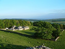
Malham Tarn is a glacial lake near the village of Malham in the Yorkshire Dales, England. The lake is one of only eight upland alkaline lakes in Europe. At an altitude of 377 metres (1,237 ft) above sea level it is the highest marl lake in the United Kingdom. Its geology, flora and fauna have led to it being listed under a number of conservation designations. The site is currently owned by the National Trust, who used to lease part of the site to the Field Studies Council but this closed as a field centre in 2022. The site was the inspiration for Charles Kingsley's 1863 novel The Water-Babies, A Fairy Tale for a Land Baby.

Hardraw Force is a waterfall on Hardraw Beck in Hardraw Scar, a wooded ravine just outside the hamlet of Hardraw, 0.9 miles (1.5 km) north of the town of Hawes, Wensleydale, in the Yorkshire Dales. The Pennine Way long distance footpath passes close by.

Grosmont is a village and civil parish situated in Eskdale in the North York Moors National Park, within the boundaries of the Scarborough district of the county of North Yorkshire, England.

Calton is a village and civil parish in the Craven district of North Yorkshire, England, on the River Aire in Airedale. In both the 2001 and 2011 Censuses the population was less than 100, so details were included in the civil parish of Flasby with Winterburn. In 2015, North Yorkshire County Council estimated the population of the village to be 60.
Malham Tarn Estate is a National Trust property in North Yorkshire, England.
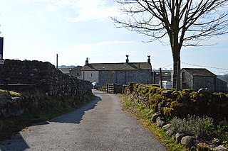
Friar Garth Farmhouse is a Grade II listed building in Malham, North Yorkshire, England. It was listed as an historic site by English Heritage on 13 September 1988.

Walter Morrison was an English Liberal and Liberal Unionist politician who sat in the House of Commons in three periods between 1861 and 1900. He was a major funder and the treasurer of the Palestine Exploration Fund; in later years the fund was dependent on his donations.
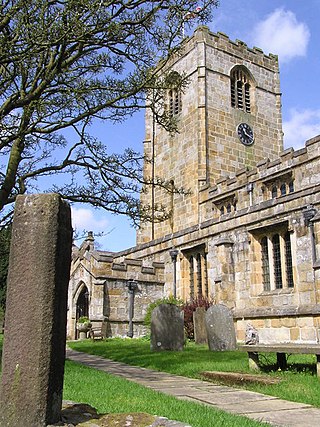
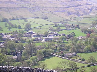
St Michael's Church is in the village of Kirkby Malham, North Yorkshire, England. It is an active Anglican parish church in the deanery of Bowland and Ewecross, the archdeaconry of Craven, and the Diocese of Leeds. It is recorded in the National Heritage List for England as a designated Grade I listed building.
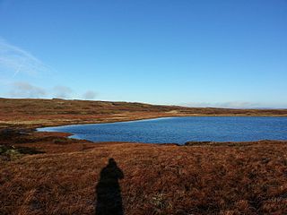
Fountains Fell Tarn, is an upland lake between the two peaks of Fountains Fell, in North Yorkshire, England. The tarn is close to the Pennine Way, some 4.3 miles (7 km) north west of Malham Tarn, and 4.3 miles (7 km) east of Horton in Ribblesdale. Water from the tarn flows eastwards through Cowside Beck, which is a tributary of the River Skirfare in Littondale. Whilst the water in the lake is acidic, as it runs off the mountain, it flows over Yoredale beds limestone and so becomes a harder water.
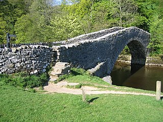
Stainforth Bridge, is a 17th century, arched packhorse bridge over the River Ribble in Stainforth, North Yorkshire, England. The bridge was formerly on the main packhorse road between York and Lancaster, which has been superseded by later roads. It was in private ownership until the 1930s, when it was taken on by the National Trust. It is now a grade II listed structure and provides access to Stainforth Force, which is just below the bridge.