
Slatina is a town in the Slavonia region of Croatia. It is located in the Virovitica-Podravina County, at the contact of the Drava valley and the foothills of Papuk mountain, in the central part of the region of Podravina, 29 km (18 mi) southeast of Virovitica; elevation 127 metres. It was ruled by Ottoman Empire between 1542 and 1687, when it was captured by Austrian troops. During Ottoman rule it was initially part of Sanjak of Pojega between 1542 and 1601, latterly part of Sanjak of Rahoviçe between 1601 and 1687. It was district centre at Virovitica County in Kingdom of Croatia-Slavonia between 1868 and 1918.

The Dubrovnik-Neretva County is the southernmost county of Croatia. The county seat is Dubrovnik and other large towns are Korčula, Metković, Opuzen and Ploče. The Municipality of Neum, which belongs to neighbouring Bosnia and Herzegovina, divides the county in two parts which are connected only by the Pelješac Bridge. The southern part of the county consists of Dubrovnik and the surrounding area, including the Pelješac peninsula, and the islands of Korčula, Lastovo, Mljet, Šipan, Lopud and Koločep. The northern part of the county includes the Neretva Delta, the Baćina lakes north of Ploče, and a swath of hinterland near the southernmost slopes of Biokovo and around the hill of Rujnica. The northern part of the Mljet island is a national park. The Lastovo archipelago is a designated nature park. The southernmost tip of the county is the Prevlaka peninsula at the border with Montenegro. It is the only Croatian county that borders Montenegro.

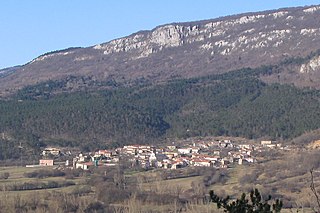
Kaptol is a village and a municipality in central Slavonia, Croatia. It is located on the slopes of Papuk mountain, east of Velika and northeast of Požega. The population of the municipality is 3,472, with 1,409 people in Kaptol itself, 97% are Croats.
Adamovec is a small town in central Croatia, north of Sesvete and southwest of Sveti Ivan Zelina. It is formally a settlement (naselje) of Zagreb, the capital of Croatia.

Vrbanja is a village and a municipality in Croatia.
Lanišće is a village and municipality in the mountainous Ćićarija area, Istria, Croatia. In 2011, the population of the village itself is 88, with a total of 329 residents in the municipality. Over 92.40% of the population are Croats. There are fourteen settlements in the municipality: Brest, Brgudac, Dane, Jelovice, Klenovšćak, Kropinjak, Lanišće, Podgaće, Prapoće, Račja Vas, Rašpor, Slum, Trstenik and Vodice.

Marčana is a village and municipality in the southern part of Istria, Croatia, 15 km northeast of Pula. The village is situated on the D66 state road.

Sveti Lovreč is a village and municipality in Istria, Croatia.

Grubišno Polje is a town in Bjelovar-Bilogora County, Croatia.

Zagvozd is a village and a seat of Zagvozd municipality in the Split-Dalmatia County, Croatia. In 2011 it had a population of 767.
Brckovljani is a village and a municipality in Zagreb County, Croatia.

Saborsko is a village and municipality in Karlovac County, Croatia. The municipality is part of the Lika region.

Donji Kraljevec is a village and municipality in Međimurje County, Croatia.

Šarengrad is a village in eastern Croatia. It is located along the Danube river and is administratively part of Croatian easternmost town of Ilok. Šarengrad is known for its landscape which is dominated by the river and picturesque houses and church tower next to it. Island of Šarengrad is an 9 km2 river island situated close to the village.

Bapska is a village in Croatia.

Mohovo is a village in Vukovar-Syrmia County in easternmost part of Croatia. It is administratively part of the town of Ilok.
Mijači is a village in the Brestovac municipality of the Požega-Slavonia County, Croatia. According to the 2001 census, there were 18 inhabitants in the village. The village is connected by the D38 state road.
Blaguša is a village in Croatia.
Grabovo is a settlement south of Vukovar, Croatia. The location was established as a pustara, a Pannonian type of hamlet. It consists of two hamlets, Ovčara and Jakobovac, in the north, which are administratively part of the city of Vukovar, and have a total population of 47, and an uninhabited section in the south which is administratively under the municipality of Tompojevci.

