Kirkovo is a village in Kardzhali Province, southern Bulgaria, near the Greek border.

Haskovski Mineralni Bani, officially known as Mineralni Bani is a spa village in central southern Bulgaria, part of Haskovo Province. It is the administrative centre of Mineralni Bani Municipality, which lies in the westernmost part of Haskovo Province. The village's name means "Haskovo Mineral Baths".

Chernoochene ; is a village in central southern Bulgaria, part of Kardzhali Province. It is the administrative centre of Chernoochene municipality, which comprises in the northernmost part of Kardzhali Province. The village is located in the Eastern Rhodope Mountains and has a predominantly Turkish population. The village's name roughly means "place of the black-eyed people" in Bulgarian and in Turkish.
Kremen is a mountainous village in southwestern Bulgaria in the Bansko Municipality of the Blagoevgrad Province. It is situated on the aastern slopes of Pirin 16 kilometers southeast of Bansko and 54 kilometers southeast of Blagoevgrad. The village is 6 kilometers away from the secondary international road 19 Blagoevgrad-Bansko-Gotse Delchev-Drama. The ruins of the Kremen fortress are situated 4 kilometers northwest of the village. The fortress is small - 600 m² and built of local stone. It is accessible only from west, where a high wall was erected, which is well preserved nowadays up to 8 meters height.

Panichishte is a resort in Bulgaria. It is located in Rila Mountain, 3 km southeast of Sapareva Banya Town and not far from Dupnitsa Town. At 1,350 meters above sea level, it lies on the border of Rila National Park. Not only it is a ski resort with sport center for various sport, but it is a spa resort too.
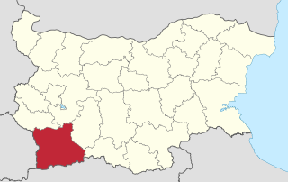
Chuchuligovo is a village in Petrich Municipality, in Blagoevgrad Province, Bulgaria.

Marikostinovo is a village in Petrich Municipality, in Blagoevgrad Province, Bulgaria.
Bozhdovo is a village in Sandanski Municipality, in Blagoevgrad Province, Bulgaria.
Golem Tsalim is a village in the municipality of Sandanski, in Blagoevgrad Province, Bulgaria.

Goleshovo is a village in the municipality of Sandanski, in Blagoevgrad Province, Bulgaria.
Ladarevo is a village in the municipality of Sandanski, in Blagoevgrad Province, Bulgaria.
Drakata is a village in Strumyani Municipality, in Blagoevgrad Province, in southwestern Bulgaria.
Palat is a village in Strumyani Municipality, in Blagoevgrad Province, in southwestern Bulgaria.
Knizhovnik is a village in the municipality of Haskovo, in Haskovo Province, in southern Bulgaria.
Dervishka mogila is a village in the municipality of Svilengrad, in Haskovo Province, in southern Bulgaria.
Dolnoseltsi is a village in the municipality of Ivaylovgrad, in Haskovo Province, in southern Bulgaria.
Kamilski Dol is a village in the municipality of Ivaylovgrad, in Haskovo Province, in southern Bulgaria.
Chervena skala is a village in Ardino Municipality, Kardzhali Province, southern-central Bulgaria. It covers an area of 2.195 square kilometres and as of 2007 had a population of 87 people.
Bozhurtsi is a village in Chernoochene Municipality, in Kardzhali Province, in southern-central Bulgaria. It covers an area of 2.106 square kilometres and as of 2007 it had a population of 258 people.
Strazhnitsa is a village in Chernoochene Municipality, in Kardzhali Province, in southern-central Bulgaria. It covers an area of 2.155 square kilometres and as of 2007 it had a population of 183 people.