The 1991 Nepal census was a widespread national census conducted by the Nepal Central Bureau of Statistics.

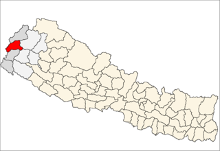
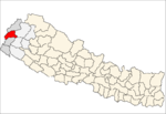
Phulpingdanda is a Village development committee in Sindhupalchok District in the Bagmati Zone of central Nepal. At the time of the 1991 Nepal census it had a population of 4085 and had 804 houses in the village.
Irkhu is a village and market center of Chautara Sangachowkgadi Municipality in Sindhupalchok District in the Bagmati Zone of central Nepal. The formerly Village Development Committee was merged to the new Municipality in 2017. At the time of the 1991 Nepal census it had a population of 2628 and had 480 houses in the village.
Lisankhu Pakhar is a Gaunpalika and former village development committee in Sindhupalchok District in Province No. 3 of central Nepal. At the time of the 1991 Nepal census it had a population of 4548 and had 890 houses in the village.
Bhimdhunga is a village and former Village Development Committee that is now part of Nagarjun Municipality in Province No. 3 of central Nepal. At the time of the 2011 Nepal census it had a population of 2,915 and had 619 houses in it.
Mahankal, Kathmandu is a village and former Village Development Committee that is now part of Budanilkantha Municipality in Kathmandu District in Province No. 3 of central Nepal. At the time of the 1991 Nepal census, it had a population of 3793 and had 710 households in it.
Nanglebhare is a village and former Village Development Committee that is now part of Shankharapur Municipality in Kathmandu District in Province No. 3 of central Nepal. At the time of the 1991 Nepal census it had a population of 4007 and had 724 households in it.
Satungal is a village and former Village Development Committee that is now part of Chandragiri Municipality in Kathmandu District in Province No. 3 of central Nepal. Satungal is also known as Satyapur. At the time of the 1991 Nepal census it had a population of 2730 and had 464 households in it. At the time of the 2001 Nepal census Satungal had a population of 5834 and had 1375 households in it. Satungal had 5173 literate people i.e. 88.66%..
Lakshmanpur is a town in Banke District in the Bheri Zone of south-western Nepal. At the time of the 1991 Nepal census it had a population of 3,416 and had 668 houses in the town.
Naubasta is a town in Banke District in the Bheri Zone of south-western Nepal. At the time of the 1991 Nepal census it had a population of 11,160 and had 1663 houses in the town.
Sirdibas is a village development committee in Gorkha District in the Gandaki Zone of northern-central Nepal. At the time of the 1991 Nepal census it had a population of 2,225 and had 480 houses in the village.
Birtadeurali is a village development committee in Kabhrepalanchok District in the Bagmati Zone of central Nepal. At the time of the 1991 Nepal census it had a population of 2648 and had 474 houses in it.
Chyamrangbesi is a village development committee in Kabhrepalanchok District in the Bagmati Zone of central Nepal. At the time of the 1991 Nepal census it had a population of 1520 and had 254 houses in it.
Devitar is a village development committee in Kabhrepalanchok District in the Bagmati Zone of central Nepal. At the time of the 1991 Nepal census it had a population of 2104 and had 335 houses in it.
Phalante Bhumlu is a village development committee in Kabhrepalanchok District in the Bagmati Zone of central Nepal. At the time of the 1991 Nepal census it had a population of 1691 and had 315 houses in it.
Ghartichhap is a village development committee in Kabhrepalanchok District in the Bagmati Zone of central Nepal. At the time of the 1991 Nepal census it had a population of 2095 and had 308 houses in it.
Gokule is a village development committee in Kabhrepalanchok District in the Bagmati Zone of central Nepal. At the time of the 1991 Nepal census it had a population of 3616 and had 604 houses in it.
Johang is a Village Development Committee VDC in Gulmi District in the Lumbini Zone of Western Nepal. At the time of the 2011 Nepal census it had a population of about 10000 living in 1509 individual households.
Situated on the bank of Kaligandaki river, Khadgakot is a town and Village Development Committee, in Gulmi District in the Lumbini Zone of central Nepal. At the time of the 1991 Nepal census it had a population of 4297 persons living in 808 individual households.
Pathari Shanishchare (पथरी-शनिश्चरे) is a Municipality in Morang District in the Koshi Zone of south-eastern Nepal. It was formed by merging two existing village development committees i.e. Pathari and Sanischare in May 2014.