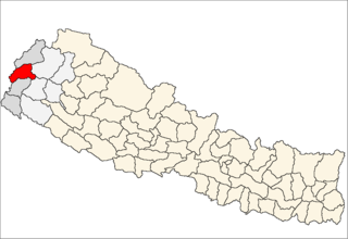
Khalanga or Baitadi Khalanga is a town and seat of Baitadi District in the Mahakali Zone of western Nepal. At the time of the 1991 Nepal census it had a population of 5,352 and had 1011 houses in the town.
Basuling is a village development committee in Baitadi District in the Mahakali Zone of western Nepal. At the time of the 1991 Nepal census it had a population of 2,642 and had 482 houses in the village.
Bhumeshwar is a village development committee in Baitadi District in the Mahakali Zone of western Nepal. At the time of the 1991 Nepal census it had a population of 2,697 and had 489 houses in the village.
Bisalpur is a village development committee in Baitadi District in the Mahakali Zone of western Nepal. At the time of the 2011 Nepal census it had a population of 4,174 and had 699 houses in the village.
Chaukham is a village development committee in Baitadi District in the Mahakali Zone of western Nepal. At the time of the 1991 Nepal census it had a population of 2,026 and 341 houses in the village.
Deulek is a village development committee in Baitadi District in the Mahakali Zone of western Nepal. At the time of the 1991 Nepal census it had a population of 2,004 and had 354 houses in the village.
Durga Bhabani is a village development committee in Baitadi District in the Mahakali Zone of western Nepal. At the time of the 1991 Nepal census it had a population of 2,052 and had 410 houses in the village.
Giregada is a village development committee in Baitadi District in the Mahakali Zone of western Nepal. At the time of the 1991 Nepal census it had a population of 2,918 and had 538 houses in the village.
Gwallek is a village development committee in Baitadi District in the Mahakali Zone of western Nepal. At the time of the 1991 Nepal census it had a population of 2,971 and had 549 houses in the village.
Kailpal is a village development committee in Baitadi District in the Mahakali Zone of western Nepal. At the time of the 2011 Nepal census it had a population of 3,074 and had 541 houses in the village.
Kotila is a village development committee in Baitadi District in the Mahakali Zone of western Nepal. At the time of the 1991 Nepal census it had a population of 2,713 and had 472 houses in the town.
Mahadevsthan is a village development committee in Baitadi District in the Mahakali Zone of western Nepal. At the time of the 1991 Nepal census it had a population of 3,291 and had 599 houses in the town.
Mahakali is a village development committee in Baitadi District in the Mahakali Zone of western Nepal. It is located on the Mahakali River which is also the border with Uttarakhand state, India across from Jhulaghat. Amraad and Basku are main places in this village. Indian and Nepalese nationals cross without restrictions, however there is a customs checkpoint for goods.
Nagarjun is a village development committee in Baitadi District in the Mahakali Zone of Far-Western Nepal. At the time of the 2011 Nepal census it had a population of 1,961 and had 412 houses in the village.
Raudidewal is a village development committee in Baitadi District in the Mahakali Zone of western Nepal. At the time of the 1991 Nepal census it had a population 3,476 and had 670 houses in the village.
Rauleshwar is a village development committee in Baitadi District in the Mahakali Zone of western Nepal. At the time of the 1991 Nepal census it had a population of 2,999 and had 546 houses in the village.
Srikedar is a village development committee in Baitadi District in the Mahakali Zone of western Nepal. At the time of the 1991 Nepal census it had a population of 2,081 and had 389 houses in the village.
Siddheshwar is a village development committee in Baitadi District in the Mahakali Zone of western Nepal. At the time of the 1991 Nepal census it had a population of 3,360 and had 563 houses in the village.
Srikot is a village development committee in Baitadi District in the Mahakali Zone of western Nepal. At the time of the 1991 Nepal census it had a population of 3,076 and had 498 houses in the village.