Udayadeb

Last updated
Udayadeb
उदयदेव
Village development committee
Nepal location map.svg
Red pog.svg
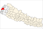
Udayadeb
Location in Nepal
Coordinates: 29°23′N80°22′E / 29.38°N 80.36°E / 29.38; 80.36 Coordinates: 29°23′N80°22′E / 29.38°N 80.36°E / 29.38; 80.36
Country Nepal
Zone Mahakali Zone
District Baitadi District
Population (1991)
  Total 3,547
  Religions Hindu
Time zone Nepal Time (UTC+5:45)

Udayadeb is a small town in Baitadi District in the Mahakali Zone of western Nepal. At the time of the 1991 Nepal census it had a population of 3,547 and had 561 houses in the town. [1]

Baitadi District District in Province No. 7, Nepal

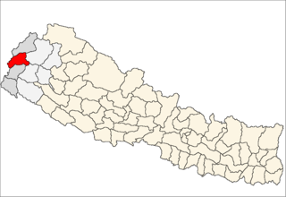
Baitadi District, historical name “Bairath” (बैराथ), a part of Province No. 7, is one of the seventy-Seven districts of Nepal. The district, with Dasharathchand as its headquarters, covers an area of 1,519 km2 and has a population of 250,898 according to the census (2011). The Baitadi district entails 56 village development councils (VDCs) and two municipality. Baitadi falls into the farthest western regional district of Nepal touching Jhulaghat, India, Nepal's neighboring country, to its border.

Mahakali Zone Zone in Nepal

Mahakali is one of the fourteen zones located in the Far-Western Development Region of Nepal, covering an area of 6,205 km2 in the most western part of the country. It stretches along Nepal's far western border with India, marked by the Kali River or Mahakali River, which originates from Limpiyadhura, a disputed location for whether or not the Tri-country border point of Nepal and India with China.

Nepal country in South Asia

Nepal, officially the Federal Democratic Republic of Nepal, is a landlocked country in South Asia. It is located mainly in the Himalayas but also includes parts of the Indo-Gangetic Plain. With an estimated population of 26.4 million, it is 48th largest country by population and 93rd largest country by area. It borders China in the north and India in the south, east, and west while Bangladesh is located within only 27 km (17 mi) of its southeastern tip and Bhutan is separated from it by the Indian state of Sikkim. Nepal has a diverse geography, including fertile plains, subalpine forested hills, and eight of the world's ten tallest mountains, including Mount Everest, the highest point on Earth. Kathmandu is the nation's capital and largest city. Nepal is a multiethnic nation with Nepali as the official language.

Related Research Articles

Jainagar, Bihar Town in Bihar, India

Jaynagar is a town and a notified area of Madhubani district in Bihar, India. It is situated on the holy Kamala River and has road and rail connections to Bihar's main cities Patna and to Nepal. The Jaynagar is connected by Nepal Railways to Janakpur in Nepal. The local language is Maithili.

Rangeli Municipality in Kosi Zone, Nepal

Rangeli is a Municipality and rural market town in Morang District in the Kosi Zone of south-eastern Nepal. This municipality was formed merging existing three villages i.e. Takuwa, Amgachhi and Rangeli itself since May 2014.

The 1991 Nepal census was a widespread national census conducted by the Nepal Central Bureau of Statistics.

Bhagavathi is a small town in Arghakhanchi District in the Lumbini Zone of southern Nepal. At the time of the 1991 Nepal census, the town had a population of 4418 living in 842 houses. At the time of the 2001 Nepal census, the population was 4543, of which 59% was literate.

Batakachaur Village development committee in Dhaulagiri Zone, Nepal

Batakachaur is a village development committee in Baglung District in the Dhaulagiri Zone of central Nepal. At the time of the 1991 Nepal census it had a population of 4,142 and had 794 houses in the village.

Lakshmanpur Village development committee in Bheri Zone, Nepal

Lakshmanpur is a town in Banke District in the Bheri Zone of south-western Nepal. At the time of the 1991 Nepal census it had a population of 3,416 and had 668 houses in the town.

Naubasta Village development committee in Bheri Zone, Nepal

Naubasta is a town in Banke District in the Bheri Zone of south-western Nepal. At the time of the 1991 Nepal census it had a population of 11,160 and had 1663 houses in the town.

Phujel Village development committee in Gandaki Zone, Nepal

Phujel is a town in Gorkha District in the Gandaki Zone of northern-central Nepal. At the time of the 1991 Nepal census it had a population of 4,563 and had 841 houses in the town.

Phinam former Village development committee in Nepal

Phinam was a village development committee in Gorkha District in the Gandaki Zone of northern-central Nepal. It was merged into Gorkha Municipality in 2014. At the time of the 1991 Nepal census it had a population of 2,993 and had 580 houses in the town.

Hansapur, Gandaki Village development committee in Gandaki Zone, Nepal

Hansapur is a village development committee in Gorkha District in the Gandaki Zone of northern-central Nepal. At the time of the 1991 Nepal census it had a population of 4,377 and had 818 houses in the town.

Muchhok Village development committee in Gandaki Zone, Nepal

Muchhok is a village development committee in Gorkha District in the Gandaki Zone of northern-central Nepal. At the time of the 1991 Nepal census it had a population of 3,663 and had 727 houses in the town.

Palumtar is a municipality in Gorkha District in the Gandaki Zone of northern-central Nepal. It was named after the former Village Development Committee which now is part of it. At the time of the 1991 Nepal census the VDC had a population of 6,982 and had 1358 houses in the town. The municipality has 23 461 inhabitants according to the census of 2011.

Pandrung Village development committee in Gandaki Zone, Nepal

Pandrung is a village development committee in Gorkha District in the Gandaki Zone of northern-central Nepal. At the time of the 1991 Nepal census it had a population of 2,803 and had 538 houses in the town.

Srinathkot Village development committee in Gandaki Zone, Nepal

Srinathkot is a village development committee in Gorkha District in the Gandaki Zone of northern-central Nepal. At the time of the 1991 Nepal census it had a population of 3,503 and had 641 houses in the town.

Simjung Village development committee in Gandaki Zone, Nepal

Simjung is a village development committee in Gorkha District in the Gandaki Zone of northern-central Nepal. At the time of the 1991 Nepal census it had a population of 5,407 and had 1080 houses in the town.

Swara, Nepal Village development committee in Gandaki Zone, Nepal

Swara is a village development committee in Gorkha District in the Gandaki Zone of northern-central Nepal. At the time of the 1991 Nepal census it had a population of 3,291 and had 652 houses in the town.

Taklung Village development committee in Gandaki Zone, Nepal

Taklung is a village development committee in Gorkha District in the Gandaki Zone of northern-central Nepal. At the time of the 1991 Nepal census it had a population of 4,835 and had 859 houses in the town.

Taple Village development committee in Gandaki Zone, Nepal

Taple is a village development committee in Gorkha District in the Gandaki Zone of northern-central Nepal. At the time of the 1991 Nepal census, it had a population of 4,398 and had 903 houses in the town.

Machchhegaun Village development committee in Bagmati Zone, Nepal

Machchhegaun is a town and municipality in Kathmandu District in the Bagmati Zone of central Nepal. At the time of the 1991 Nepal census it had a population of 5951 in 979 individual households.

Laxmipur is a former town and Village Development Committee in Ilam District in the Mechi Zone of eastern Nepal.

References

  1. "Nepal Census 2001". Nepal's Village Development Committees. Digital Himalaya . Retrieved 2008-08-26.