The 1991 Nepal census was a widespread national census conducted by the Nepal Central Bureau of Statistics.

Phulpingdanda is a Village development committee in Sindhupalchok District in the Bagmati Zone of central Nepal. At the time of the 1991 Nepal census it had a population of 4085 and had 804 houses in the village.
Pagretar is a village development committee in Sindhupalchowk District in the Bagmati Zone of central Nepal. Kothe is a populated location within the committee area. At the time of the 2001 Nepal census Pagretar had a population of 3352, and in 1991 there were 633 houses. By 2011 the population had become 2952 in 762 households.
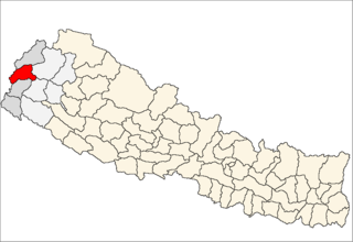
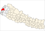
Siddheshwar is a village development committee in Baitadi District in the Mahakali Zone of western Nepal. At the time of the 1991 Nepal census it had a population of 3,360 and had 563 houses in the village.
Nanglebhare is a village and former Village Development Committee that is now part of Shankharapur Municipality in Kathmandu District in Province No. 3 of central Nepal. At the time of the 1991 Nepal census it had a population of 4007 and had 724 households in it.
Sangla is a village and former Village Development Committee that is now part of Tarakeshwar Municipality in Kathmandu District in Province No. 3 of central Nepal. At the time of the 1991 Nepal census it had a population of 2625 and had 515 households in it.
Satungal is a village and former Village Development Committee that is now part of Chandragiri Municipality in Kathmandu District in Province No. 3 of central Nepal. Satungal is also known as Satyapur. At the time of the 1991 Nepal census it had a population of 2730 and had 464 households in it. At the time of the 2001 Nepal census Satungal had a population of 5834 and had 1375 households in it. Satungal had 5173 literate people i.e. 88.66%..
Sitapaila is a village and former Village Development Committee that is now part of Nagarjun Municipality in Province No. 3 of central Nepal. At the time of the 1991 Nepal census it had a population of 5156 and had 1008 households in it.
Sokhek is a village and former Village Development Committee that is now part of Dakshinkali Municipality in Kathmandu District in Province No. 3 of central Nepal. At the time of the 1991 Nepal census it had a population of 3980 and had 684 households in it.
Suntol is a village and former Village Development Committee that is now part of Shankharapur Municipality in Kathmandu District in Province No. 3 of central Nepal. At the time of the 1991 Nepal census it had a population of 3980 and had 684 households in it.
Lakshmanpur is a town in Banke District in the Bheri Zone of south-western Nepal. At the time of the 1991 Nepal census it had a population of 3,416 and had 668 houses in the town.
Naubasta is a town in Banke District in the Bheri Zone of south-western Nepal. At the time of the 1991 Nepal census it had a population of 11,160 and had 1663 houses in the town.
Gumda is a village development committee in Gorkha District in the Gandaki Zone of northern-central Nepal. At the time of the 1991 Nepal census it had a population of 2,312 and had 481 houses in the village.
Prok is a village development committee in Gorkha District in the Gandaki Zone of northern-central Nepal. At the time of the 1991 Nepal census it had a population of 739 and had 219 houses in the village.
Phalante Bhumlu is a village development committee in Kabhrepalanchok District in the Bagmati Zone of central Nepal. At the time of the 1991 Nepal census it had a population of 1691 and had 315 houses in it.
Phalemetar is a village development committee in Kabhrepalanchok District in the Bagmati Zone of central Nepal. At the time of the 1991 Nepal census it had a population of 3560 and had 568 houses in it.
Phoksingtar is a village development committee in Kabhrepalanchok District in the Bagmati Zone of central Nepal. At the time of the 1991 Nepal census it had a population of 1938 and had 291 houses in it.
Situated on the bank of Kaligandaki river, Khadgakot is a town and Village Development Committee, in Gulmi District in the Lumbini Zone of central Nepal. At the time of the 1991 Nepal census it had a population of 4297 persons living in 808 individual households.
Pathari Sanischare (पथरी-शनिश्चरे) is a Municipality in Morang District in the Koshi Zone of south-eastern Nepal. It was formed by merging two existing village development committees i.e. Pathari and Sanischare in May 2014.