
Ann Arbor is a city in the U.S. state of Michigan and the county seat of Washtenaw County. The 2010 census recorded its population to be 113,934. It is the principal city of the Ann Arbor Metropolitan Statistical Area, which encompasses all of Washtenaw County. Ann Arbor is also included in the larger Greater Detroit Combined Statistical Area.

The Au Sable River in Michigan, United States runs approximately 138 miles (222 km) through the northern Lower Peninsula, through the towns of Grayling and Mio, and enters Lake Huron at the town of Oscoda. It is considered one of the best brown trout fisheries east of the Rockies and has been designated a blue ribbon trout stream by the Michigan Department of Natural Resources. French Rivière au sable means "Sand River." A 1795 map calls it the Beauais River.

Washtenaw County is a county located in the U.S. state of Michigan. As of the 2010 census, the population was 344,791. The county seat is Ann Arbor. The county was authorized by legislation in 1822, and was organized as a county in 1826. Washtenaw County comprises the Ann Arbor Metropolitan Statistical Area and is included in the Detroit-Warren-Ann Arbor Combined Statistical Area. The county is home to the University of Michigan, Eastern Michigan University, Washtenaw Community College, and Concordia University Ann Arbor.

Dexter is a city in Washtenaw County in the U.S. state of Michigan. Originally a village, Dexter residents voted to adopt a city charter in November 2014. The population was 4,067 at the 2010 census. Between 2000 and 2010, Dexter's population grew 73.9%, making it one of the fastest growing communities in the state.

Pittsfield Township, officially the Charter Township of Pittsfield, is a charter township south of Ann Arbor in Washtenaw County in the U.S. state of Michigan. The population was 34,663 at the 2010 census.

Superior Township, officially the Charter Township of Superior, is a charter township in Washtenaw County in the U.S. state of Michigan. The population was 13,058 at the 2010 census.

The Huron River is a 130-mile-long (210 km) river in southeastern Michigan, rising out of the Huron Swamp in Springfield Township in northern Oakland County and flowing into Lake Erie, as it forms the boundary between present-day Wayne and Monroe counties. Thirteen parks, game areas, and recreation areas are associated with the river, which passes through the cities of Dexter, Ann Arbor, Ypsilanti, Belleville, Flat Rock and Rockwood that were developed along its banks.
The Clinton River is a river in southeastern Michigan in the United States. It is named in honor of DeWitt Clinton, who was governor of New York from 1817 to 1823.
The River Rouge is a 127-mile river in the Metro Detroit area of southeastern Michigan. It flows into the Detroit River at Zug Island, which is the boundary between the cities of River Rouge and Detroit.
M-17 is a 6.390-mile-long (10.284 km) state trunkline highway in the U.S. state of Michigan, connecting the cities of Ypsilanti and Ann Arbor in Washtenaw County. It was once part of a highway that spanned the southern Lower Peninsula of Michigan before the creation of the U.S. Highway System in 1926. The designation once extended into downtown Detroit, but the eastern terminus was progressively scaled back in the late 1960s to the current location in Ypsilanti. The changes made to the highways in Washtenaw County spawned Business M-17, a business loop for 11 years between 1945 and 1956.

John Hieftje is an American politician who served as the 60th mayor of Ann Arbor, Michigan. Hieftje began his political career in 1999, when he was elected to the city council for Ann Arbor's 1st Ward as a Democrat. He was first as Mayor in 2000, and was re-elected in 2002, 2004, 2006, 2008, 2010 and 2012.

The Shiawassee River in the U.S. state of Michigan drains an area of 1,201 square miles (3,110 km2) within Oakland, Genesee, Livingston, Shiawassee, Midland and Saginaw counties. It flows in a generally northerly direction for about 110 miles (180 km) from its source to its confluence with the Tittabawassee River creating the Saginaw River, which drains into the Saginaw Bay of Lake Huron.

Lake Erie Basin consists of Lake Erie and surrounding watersheds, which are typically named after the river, creek, or stream that provides drainage into the lake. The watersheds are located in the states of Indiana, Michigan, New York, Ohio, and Pennsylvania in the United States, and in the province of Ontario in Canada. The basin is part of the Great Lakes Basin and Saint Lawrence River Watershed, which feeds into the Atlantic Ocean. 80% of the lake's water flows in from the Detroit River, with only 9% coming from all of the remaining watersheds combined. A littoral zone serves as the interface between land and lake, being that portion of the basin where the lake is less than 15 feet (4.6 m) in depth.

The Ann Arbor District Library (AADL) is a public library system that serves the residents of Ann Arbor, Michigan. The Downtown Library, located at 343 South Fifth Avenue, was dedicated in 1957 and had building additions in 1974 and 1991. AADL also includes four branch libraries: Malletts Creek, Traverwood, Pittsfield and Westgate. The library system holds over 490,000 materials – books, DVDs, compact discs, magazines, audio books and other formats. More than 1.5 million people came through the doors of the AADL system in 2011–12, and circulation of library materials topped 8.5 million. In 1997, the Library was named “National Library of the Year” by Library Journal, the first library in Michigan to receive the honor.

Women's Huron Valley Correctional Facility (WHV) is a prison for women located in Pittsfield Township, operated by the Michigan Department of Corrections (MDOC). The three-letter designation for this facility is WHV. It is the only prison in Michigan which houses women.

Ypsilanti, commonly shortened to Ypsi, is a city in Washtenaw County in the U.S. state of Michigan, perhaps best known as the home of Eastern Michigan University. As of the 2010 census, the city's population was 19,435. The city is bounded to the north by Superior Township and on the west, south, and east by Ypsilanti Township.

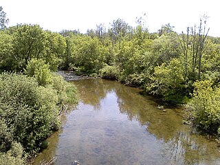
Paint Creek is a stream mostly located within Washtenaw County in the U.S. state of Michigan. The stream flows south before entering as a tributary to Stony Creek along the county line with Monroe County.

Nelson Meade County Farm Park is a 141-acre public park in eastern Ann Arbor, Michigan owned by Washtenaw County and operated by the county's Parks and Recreation Commission. Consisting of a mix of woodlands, fields, and gardens, the park is home to a wide variety of flora and fauna and is a popular local destination for gardening, hiking, jogging, and biking. The park has been county land since 1836, although for the majority of the nineteenth and twentieth centuries it was used as the county's poorhouse and then as its infirmary. In 1972, the site began transitioning to parkland with the creation of community gardens, and over the next couple decades various trails and a perennial garden were created. Since 2000, the park has experienced significant ecological restoration efforts, including the removal of invasive plants, prairie restoration, and the creation of a wet meadow during the restoration of Malletts Creek.

Ford Lake is a fresh water artificial reservoir located in Washtenaw County in the U.S. state of Michigan. The lake was created from the construction of Ford Lake Dam along the Huron River in the early 1930s. The lake is named after business magnate Henry Ford.

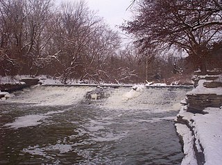
The Superior Dam is a hydroelectric barrage dam crossing the Huron River. It is located in Superior Township in Washtenaw County in the U.S. state of Michigan. It was completed in 1920 and currently provides hydroelectricity to the nearby city of Ann Arbor, which owns and maintains the dam and power station.
