South Africa occupies the southern tip of Africa, its coastline stretching more than 2,850 kilometres from the desert border with Namibia on the Atlantic (western) coast southwards around the tip of Africa and then northeast to the border with Mozambique on the Indian (eastern) coast. The low-lying coastal zone is narrow for much of that distance, soon giving way to a mountainous escarpment that separates the coast from the high inland plateau. In some places, notably the province of KwaZulu-Natal in the east, a greater distance separates the coast from the escarpment. Although much of the country is classified as semi-arid, it has considerable variation in climate as well as topography. The total land area is 1,220,813 km2 (471,359 sq mi). It has the 23rd largest Exclusive Economic Zone of 1,535,538 km2 (592,875 sq mi).

KwaZulu-Natal is a province of South Africa that was created in 1994 when the government merged the Zulu bantustan of KwaZulu and Natal Province.

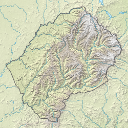
The Drakensberg is the eastern portion of the Great Escarpment, which encloses the central Southern African plateau. The Great Escarpment reaches its greatest elevation – 2,000 to 3,482 metres within the border region of South Africa and Lesotho.

A transboundary protected area (TBPA) is an ecological protected area that spans boundaries of more than one country or sub-national entity. Such areas are also known as transfrontier conservation areas (TFCAs) or peace parks.

iSimangaliso Wetland Park is situated on the east coast of KwaZulu-Natal, South Africa, about 235 km (146 mi) north of Durban by road. It is South Africa's third-largest protected area, spanning 280 km (170 mi) of coastline, from the Mozambican border in the north to Mapelane south of the Lake St. Lucia estuary, and made up of around 3,280 km2 of natural ecosystems, managed by the iSimangaliso Authority. The park includes:
The Lubombo Transfrontier Conservation Area was born out of the Peace Park Foundation’s vision to establish a network of transfrontier conservation areas in southern Africa. It straddles the border between South Africa’s KwaZulu-Natal province, southern Mozambique, and Eswatini.

Ezemvelo KZN Wildlife is a governmental organisation responsible for maintaining wildlife conservation areas and biodiversity in KwaZulu-Natal Province, South Africa. Their headquarters is in Queen Elizabeth Park situated on the northern slopes of Pietermaritzburg, the KwaZulu-Natal provincial capital. Prior to 1994, it was known as the Natal Parks Board.
KwaZulu-Natal is one of the most diverse provinces in South Africa in terms of its fauna and flora. Many of its wide variety of ecosystems have been preserved as parks and reserves, which are popular tourist attractions. Ezemvelo KZN Wildlife is a governmental agency that maintains the wildlife conservation areas in the province.

Himeville is a small village/town situated in the foothills of the picturesque Southern Drakensberg, KwaZulu-Natal, South Africa, approx 130 km from Pietermaritzburg. It is a landmark en route to the world-famous Sani Pass and the uKhahlamba Drakensberg Park. Himeville is the closest town to the Sani Pass which links the town with Mokhotlong in Lesotho.

The Maloti Mountains are a mountain range of the highlands of the Kingdom of Lesotho. They extend for about 100 km into the South African Free State. The Maloti Range is part of the Drakensberg system that includes ranges across large areas of South Africa. "Maloti" is also the plural for Loti, the currency of the Kingdom of Lesotho. The range forms the northern portion of the boundary between the Butha-Buthe District in Lesotho and South Africa's Free State.

Royal Natal National Park is a 80.94-square-kilometre (31.25 sq mi) park in the KwaZulu-Natal province of South Africa and forms part of the uKhahlamba Drakensberg Park, a UNESCO World Heritage Site. Notwithstanding the name, it is actually not a South African National Park managed by the SANParks, but rather a Provincial Park managed by Ezemvelo KZN Wildlife. This park is now included in the Maloti-Drakensberg Transfrontier Conservation Area, a Peace Park.

The Sehlabathebe National Park is located in the Maloti Mountains in Qacha's Nek District, Lesotho and is part of the Maloti-Drakensberg World Heritage Site. The park was first established on 8 May 1969 and since then, is recognised as important in terms of biological diversity and cultural heritage. The landscape is dominated by grasslands of various types. The larger ecosystem functions provide freshwater to Lesotho, South Africa, and Namibia.

The uKhahlamba-Drakensberg Park is a protected area in the KwaZulu-Natal province of South Africa, covering 2,428.13 km2 (938 sq mi), and is part of the Maloti-Drakensberg Park, a UNESCO World Heritage Site. The park includes Royal Natal National Park, a Provincial park, and covers part of the Drakensberg, an escarpment formation with the highest elevations in southern Africa.

Ponta do Ouro-Kosi Bay Transfrontier Conservation Area (TFCA) is a larger conservation area conceived as an extension of the existing conservation parkland area of the iSimangaliso Wetland Park, to extend north into a similar area on the Mozambique side of the border, and including several other parks in the process. The parks to be included are:

Matatiele Municipality is a local municipality within the Alfred Nzo District Municipality, in the Eastern Cape province of South Africa. It adjoins Lesotho to the north, Elundini to the south-west, and Greater Kokstad to the east and its 4,352 km² makes the Matatiele Municipality largest of four municipalities in the district at almost half of its geographical area. According to the South African National Census of 2011, its 203,483 residents and 49,527 households makes Matatiele Municipality the second largest populated area in the Alfred Nzo District Municipality behind Mbizana.
The Peace Park Foundation, founded in 1997 by Dr Anton Rupert, President Nelson Mandela and Prince Bernhard of the Netherlands, is an organisation that aims to re-establish, renew and conserve large ecosystems in Africa, transcending man-made boundaries by creating regionally integrated and sustainably managed networks of Transfrontier Conservation Areas (TFCAs). Peace Parks Foundation has been involved in the establishment and development of ten of the 18 TFCAs found throughout southern Africa, all of which are in various stages of development. The establishment of each TFCA, or peace park, is complex and far-reaching, and involves several phases of activity, which can take many years to achieve.
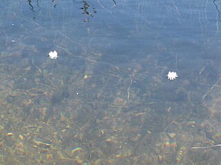
Aponogeton ranunculiflorus, the Sehlabathebe water lily, is a tiny and endangered species of aquatic plant, that belongs to the pondweed family Aponogetonaceae. It is protected in the Sehlabathebe National Park in the mountains of Lesotho, where it is very localised, and nearby in the uKhahlamba / Drakensberg Park of KwaZulu-Natal, South Africa. Outside these areas it is seriously threatened. It is found in sandstone rock pools, up to 7 metres deep, and in permanently wet tarns or sensitive high altitude mires, at altitudes between about 2,600 and 3,200 metres. Its spiralled stems allow the flowers to remain at surface level. Threats to the species include overgrazing and trampling by cattle, overburning, erosion and subsistence farming. Their small (1 cm) corms can survive the drying out of the pools, or being frozen into the muddy bottoms.
The marine protected areas of South Africa are in an area of coastline or ocean within the exclusive economic zone (EEZ) of the Republic of South Africa that is protected in terms of specific legislation for the benefit of the environment and the people who live in and use it. An MPA is a place where marine life can thrive under less pressure than unprotected areas. They are like underwater parks, and this healthy environment can benefit neighbouring areas.
The following index is provided as an overview of and topical guide to the protected areas of South Africa: