
Malta, officially the Republic of Malta, is an island country in southern Europe, located in the Mediterranean Sea. It consists of an archipelago between Italy, Tunisia and Libya. It lies 80 km (50 mi) south of Sicily, Italy, 284 km (176 mi) east of Tunisia, and 333 km (207 mi) north of Libya. The two official languages are Maltese, the only Semitic language in Europe and the European Union, and English. The nation's capital is Valletta.

Valletta is an administrative unit and the capital of Malta. Located on the main island, between Marsamxett Harbour to the west and the Grand Harbour to the east, its population within administrative limits in 2014 was 6,444. According to the data from 2020 by Eurostat, the Functional Urban Area and metropolitan region covered the whole island and has a population of 480,134. Valletta is the southernmost capital of Europe, and at just 0.61 square kilometres (0.24 sq mi), it is the European Union's smallest capital city.
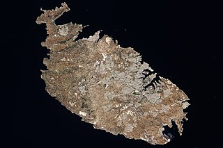
Malta is an island in Southern Europe. It is the largest and most populous of the three major islands that constitute the Maltese Archipelago.The island is situated in the Mediterranean Sea directly south of Italy and north of Libya. It lie south-east of the smaller islands of Gozo and Comino.The island is 27 kilometres (17 mi) long and 14.5 kilometres (9 mi) wide, with a total area of 246 square kilometres (95 sq mi). The capital is Valletta, while the largest locality is Rabat. The island is made up of many small towns, which together form one larger urban zone with a population of 409,259. The landscape is characterised by low hills with terraced fields.
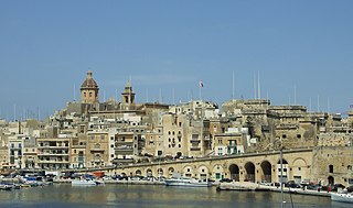
Birgu, also known by its title Città Vittoriosa, is an old fortified city on the south side of the Grand Harbour in the South Eastern Region of Malta. The city occupies a promontory of land with Fort Saint Angelo at its head and the city of Cospicua at its base. Birgu is ideally situated for safe anchorage, and over time it has developed a very long history with maritime, mercantile and military activities.

Senglea, also known by its title Città Invicta, is a fortified city in the South Eastern Region of Malta. It is one of the Three Cities in the Grand Harbour area, the other two being Cospicua and Vittoriosa, and has a population of approximately 2,720 people. The city's title Città Invicta was given because it managed to resist the Ottoman invasion at the Great Siege of Malta in 1565. The name Senglea comes from the Grand Master who built it Claude de la Sengle and gave the city a part of his name. While Senglea is the 52nd most populated locality on the island, due to its incredibly small land area, it is the 2nd most densely populated locality after Sliema.

Gudja is a village in the Southern Region of Malta, with a population of 3,148 as of March 2017. The village is located on high grounds, south of Valletta. It is administered by the Gudja Local Council. A number of schools, clubs, public gardens and recreations places are found around the village.
The Three Cities is a collective description of the three fortified cities of Vittoriosa, Senglea and Cospicua in Malta. The oldest of the Three Cities is Vittoriosa, which has existed since prior to the Middle Ages. The other two cities, Senglea and Cospicua, were both founded by the Order of Saint John in the 16th and 17th centuries. The Three Cities are enclosed by the Cottonera Lines, along with several other fortifications. The term Cottonera is synonymous with the Three Cities, although it is sometimes taken to also include the nearby town of Kalkara.
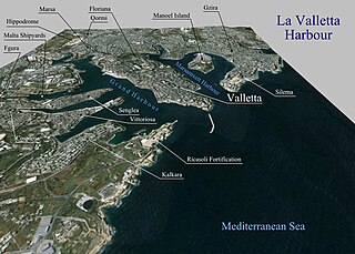
The Grand Harbour, also known as the Port of Valletta, is a natural harbour on the island of Malta. It has been substantially modified over the years with extensive docks, wharves, and fortifications.

Marsamxett Harbour, historically also referred to as Marsamuscetto, is a natural harbour on the island of Malta. It is located to the north of the larger Grand Harbour. The harbour is generally more dedicated to leisure use than the Grand Harbour.

Malta is for non-local government purposes divided into districts as opposed to the local government localities. The three main types of such districts – statistical, electoral at national level, and policing – have no mainstream administrative effect as the local councils form the first-tier – moreover only administrative tier – divisions of the country.
This page list topics related to Malta.
Malta is subdivided into 6 regions. Three regions were originally created by the Local Councils Act of 1993, and were integrated into the constitution in 2001. Two of the regions were split into smaller ones by Act No. XVI of 2009, and Malta was divided into five regions.Act No. XIV of 2019 reorganized the subdivision, establishing six regions, and was implemented in November 2021

Gozo Region is one of five regions of Malta. The region includes the islands of Gozo, Comino and several little islets such as Cominotto. The region does not border with any other regions, but it is close to the Northern Region.

Malta Majjistral, also known as the North Western Region, was a region of Malta between 1993 and 2009. It was located on the main island of Malta, bordering Malta Xlokk. The name referred to the Mistral wind, which is Majjistral in Maltese.

The Northern Region is one of five regions of Malta. The region includes the northwestern part of the main island of Malta. The region borders the Central and Southern Regions, and is also close to Gozo Region.

The Central Region is a former region of Malta. The region included the central part of the main island of Malta, and bordered the Northern, Southern and South Eastern Regions.
The South Eastern Region is a former region of Malta. The region included the southeastern part of the main island of Malta, including the capital Valletta. The region bordered the Central and Southern Regions.

The Southern Region is one of five regions of Malta. The region includes the southern part of the main island of Malta. The region borders the Northern, Central and South Eastern Regions.

The Banca Giuratale, formerly also known as Banca dei Giurati, the Municipal Palace, the Palazzo della Città, Casa Città and the Consolato del Mare, is a public building in Valletta, Malta. It was built in the 18th century to house the city's administrative council, and it was subsequently used as the General Post Office and the Public Registry. The Banca Giuratale now houses the Ministry for the Economy,Enterprise and Strategic Projects, and it is officially known as Palazzo Zondadari.

The Valletta Summit on Migration, also called the Valletta Conference on Migration, was a summit held in Valletta, Malta, on 11–12 November 2015, in which European and African leaders discussed the European migrant crisis. The summit resulted in the EU setting up an Emergency Trust Fund to promote development in Africa, in return for African countries to help out in the crisis.


