The Northwest Territories is a federal territory of Canada. At a land area of approximately 1,144,000 km2 (442,000 sq mi) and a 2016 census population of 41,790, it is the second-largest and the most populous of the three territories in Northern Canada. Its estimated population as of 2023 is 45,668. Yellowknife is the capital, most populous community, and only city in the territory; its population was 19,569 as of the 2016 census. It became the territorial capital in 1967, following recommendations by the Carrothers Commission.
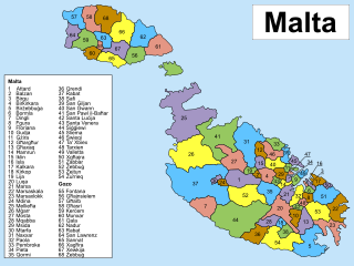
Since June 30, 1993, Malta has been subdivided into 68 localities, governed by local councils, Maltese: kunsilli lokali, meaning municipalities or borough, and the considered by the Maltese as the equivalent to a basic village or towns, where appropriate. These form the most basic form of local government and there are no intermediate levels between it and the national level. The levels of the 6 districts and of the 5 regions serve statistical purposes.
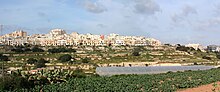
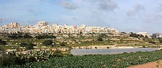
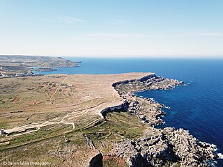
Mellieħa is a large village in the Northern Region of Malta. It has a population of 10,087 as of March 2014. Mellieħa is also a tourist resort, popular for its sandy beaches, natural environment, and Popeye Village nearby.

Central Luzon, designated as Region III, is an administrative region in the Philippines, primarily serving to organize the 7 provinces of the vast central plains of the island of Luzon, for administrative convenience. The region contains the largest plain in the country and produces most of the country's rice supply, earning itself the nickname "Rice Granary of the Philippines". Its provinces are: Aurora, Bataan, Bulacan, Nueva Ecija, Pampanga, Tarlac and Zambales. Pangasinan was formerly a province of Central Luzon before President Marcos signed Presidential Decree No. 1, 1972, incorporating it into Ilocos Region. Additionally, the province of Aurora was part of the defunct political region Southern Tagalog when the region was divided into Calabarzon and Mimaropa, upon the issuance of Executive Order No. 103, dated May 17, 2002, by then-President Gloria Macapagal Arroyo, which transferred Aurora to Central Luzon.

Southern Europe is the southern region of Europe. It is also known as Mediterranean Europe, as its geography is marked by the Mediterranean Sea. Definitions of southern Europe include some or all of these countries and regions: Albania, Andorra, Bosnia and Herzegovina, Bulgaria, Croatia, Cyprus, Gibraltar, Greece, Italy, Kosovo, Malta, Monaco, Montenegro, North Macedonia, Portugal, San Marino, Serbia, Slovenia, southern France, Spain, Turkey, and Vatican City.

Żabbar, also known as Città Hompesch, is a city in the South Eastern Region of Malta. It is the seventh largest city in the country, with an estimated population of 15,648 as of January 2021. Originally a part of Żejtun, Żabbar was granted the title of Città Hompesch by the last of the Grand Masters of the Order of St. John to reign in Malta, Ferdinand von Hompesch zu Bolheim.
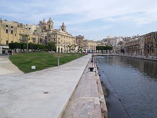
Cospicua, also known by its titles Città Cospicua or Civitas Cottonera, is a double-fortified harbour city in the South Eastern Region of Malta. Along with Birgu and Senglea, it is one of the Three Cities, located within the Grand Harbour to the east of the capital city Valletta. With a population of 5,395 as of March 2014, it is the most dense city of the Three Cities.
The Métis Nation—Saskatchewan is a federally-recognized government that represents Métis people in the province of Saskatchewan, Canada. It is affiliated with the Métis National Council. Glen McCallum was elected as president in 2017 and reelected in 2021.
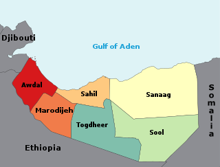
The regions of Somaliland is divided into six administrative regions, Awdal, Sahil, Maroodi-Jeeh, Togdheer, Sanaag and Sool. These are in turn subdivided into twenty-two districts. Regions of Somaliland are the primary geographical divisions through which Somaliland is administered. A distinction is made between districts of grades A, B, C and D, with the classification being based on population, area, economy and production.

Malta is for non-local government purposes divided into districts as opposed to the local government localities. The three main types of such districts – statistical, electoral at national level, and policing – have no mainstream administrative effect as the local councils form the first-tier – moreover only administrative tier – divisions of the country.

Ginninderra Creek, a partly perennial stream of the Murrumbidgee catchment within the Murray–Darling basin, is located in the Capital Country region spanning both the Australian Capital Territory and New South Wales, Australia.

The West is a strategic planning area within the Northern and Western Region in Ireland. It is a NUTS Level III statistical region of Ireland under the Eurostat classification. It consists of the counties of Galway, Mayo and Roscommon, and the city of Galway. The West spans 13,801 km2 and as of the 2022 census has a population of 485,966.
Malta is subdivided into 5 regions. Three regions were originally created by the Local Councils Act of 1993, and were integrated into the constitution in 2001. Two of the regions were split into smaller ones by Act No. XVI of 2009, and now there are five regions. Malta is divided into five regions without administrative functions.

Gozo Region is one of five regions of Malta. The region includes the islands of Gozo, Comino and several little islets such as Cominotto. The region does not border with any other regions, but it is close to the Northern Region.
Malta Xlokk, also known as the South Eastern Region, was a region of Malta between 1993 and 2009. It was located on the main island of Malta, bordering Malta Majjistral. It included the capital Valletta. The name referred to the Sirocco wind, which is Xlokk in Maltese.

The Northern Region is one of five regions of Malta. The region includes the northwestern part of the main island of Malta. The region borders the Central and Southern Regions, and is also close to Gozo Region.
The Central Region is one of five regions of Malta. The region includes the central part of the main island of Malta. The region borders the Northern, Southern and South Eastern Regions.

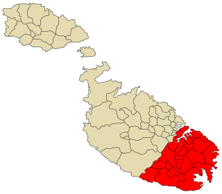
The South Eastern Region is one of five regions of Malta. The region includes the southeastern part of the main island of Malta, including the capital Valletta. The region borders the Central and Southern Regions.

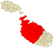
The Southern Region is one of five regions of Malta. The region includes the southern part of the main island of Malta. The region borders the Northern, Central and South Eastern Regions.
The Majjistral Nature and History Park is a nature reserve in Mellieha, Malta. The geographic area includes the coastal area in Golden Bay to Il-Prajjet and Ix- Xagħra l-Ħamra. It was declared a national park on the Malta Government Gazette by Legal Notice 251 of 2007 in September 2007. The park is named for the northwestern region or wind.