Maly Begichev Island

Last updated
Location of Maly Begichev and Bolshoy Begichev islands in the Khatanga Gulf. Kara sea2BB.PNG
Location of Maly Begichev and Bolshoy Begichev islands in the Khatanga Gulf.

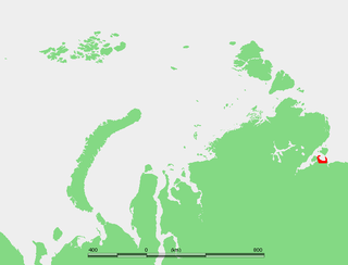
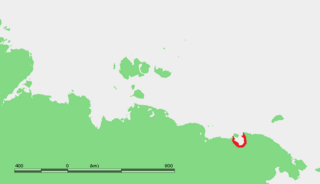
Maly Begichev (Russian : Малый Бегичев) is an island in the Laptev Sea, Russia. Its area is 15 km². This small island (maximum length 5.4 km) is situated within the Khatanga Gulf (Russian: Хатангский залив).

Russian language East Slavic language

Russian is an East Slavic language, which is official in the Russian Federation, Belarus, Kazakhstan and Kyrgyzstan, as well as being widely used throughout Eastern Europe, the Baltic states, the Caucasus and Central Asia. It was the de facto language of the Soviet Union until its dissolution on 25 December 1991. Although nearly three decades have passed since the breakup of the Soviet Union, Russian is used in official capacity or in public life in all the post-Soviet nation-states, as well as in Israel and Mongolia.

Laptev Sea Marginal sea in the Arctic Ocean north of Siberia between the Kara Sea and the East Siberian Sea

The Laptev Sea is a marginal sea of the Arctic Ocean. It is located between the northern coast of Siberia, the Taimyr Peninsula, Severnaya Zemlya and the New Siberian Islands. Its northern boundary passes from the Arctic Cape to a point with co-ordinates of 79°N and 139°E, and ends at the Anisiy Cape. The Kara Sea lies to the west, the East Siberian Sea to the east.

Khatanga Gulf bay

The Khatanga Gulf or Khatanga Bay is a large tidal estuary in the Laptev Sea. It is relatively narrow, its length being 220 km with a maximum width of 54 km.

Only 8.5 km east of it lies the big island known as Bolshoy Begichev Island. Its size is much larger, with an area of 1764 km sq. The border between administrative divisions of the Russian Federation runs between the two Begichev islands, so that while Maly Begichev is in Krasnoyarsk Krai, Bolshoy Begichev is in the Sakha Republic.

Bolshoy Begichev Island island

Bolshoy Begichev is an island in the Laptev Sea, Russia.

Krasnoyarsk Krai First-level administrative division of Russia

Krasnoyarsk Krai is a federal subject of Russia, with its administrative center in the city of Krasnoyarsk—the third-largest city in Siberia. Comprising half of the Siberian Federal District, Krasnoyarsk Krai is the largest krai in the Russian Federation, the second largest federal subject and the third largest subnational governing body by area in the world, after Sakha and the Australian state of Western Australia. The krai covers an area of 2,339,700 square kilometers (903,400 sq mi), which is nearly one quarter the size of the entire country of Canada, constituting roughly 13% of the Russian Federation's total area and containing a population of 2,828,187, or just under 2% of its population, per the 2010 Census.

Sakha Republic First-level administrative division of Russia

The Republic of Sakha (Yakutia) is a federal Russian republic. It had a population of 958,528 at the 2010 Census, mainly ethnic Yakuts and Russians.

Both islands are named after Russian polar explorer Nikifor Begichev.

Nikifor Begichev Russian seaman and polar explorer

Nikifor Alekseevich Begichev (Bigichev) (Russian: Никифор Алексеевич Бегичев was a Soviet seaman and polar explorer. He was twice awarded gold medals by the Russian Academy of Sciences

Related Research Articles

Lyakhovsky Islands island group

The Lyakhovsky Islands are the southernmost group of the New Siberian Islands in the arctic seas of eastern Russia. The islands are named in honour of Ivan Lyakhov, who explored them in 1773.

Bolshoy Ussuriysky Island sedimentary island at the confluence of the Ussuri and Amur rivers

Bolshoi Ussuriysky Island, or Heixiazi Island, is a sedimentary island at the confluence of the Ussuri and Amur rivers. It is divided between the People's Republic of China (PRC) and Russia. It has an area of about 327 to 350 km² and is bounded closely by Yinlong Island, and over ninety islets. Its position at the confluence of the Amur and the Ussuri and right next to the major Russian city of Khabarovsk, has given it great strategic importance.

Shantar Islands Island group in Far Eastern Federal District, Russian Federation

The Shantar Islands are a group of fifteen islands located off the northwestern shore of the Sea of Okhotsk east of Uda Gulf and north of Academy Bay. Most of the islands have rugged cliffs, but they are of moderate height; the highest point in the island group is 720 metres. The name of the island group has its origins in the Nivkh language from the word ч’андь/č’and’’ meaning "to be white". The islands are currently uninhabited.

Bolshoy Shantar Island island

Bolshoy Shantar is an island in the Sea of Okhotsk, Russia. It is the main island of the Shantar Islands. Its area is 1766 km². It is about 72 km (44.7 mi) in length and 49 km (30.4 mi) in width. It has a large brackish lake on its north side which is connected to the sea through a narrow passage. Yakshin Bay indents the southwest side of the island.

Nordvik, Russia human settlement in Russia

Nordvik was a settlement and a harbor-port in Krasnoyarsk Krai, Russian SFSR, Soviet Union, located on the Khatanga Gulf at the mouth of the Khatanga River, on the Uryung Tumus Peninsula, west of Nordvik Bay.

Kolchak Island island in Russia

Kolchak Island or Kolchaka Island, is an island in the Kara Sea located in a coastal area of skerries NE of the Shturmanov Peninsula. It is near the southern end of the Nordenskiöld Archipelago, but not geographically part of it.

Labyrintovye Islands Russian islands in the Arctic Sea

The Labyrintovye Islands is a group of flat islands in the Pyasino Gulf of the Kara Sea. They are located at the mouth of the Pyasina River. Their latitude is 73° 50' N and its longitude 86° 45' E.

Peschany Island Island in Sakha Republic, Russian Federation

Peschany Island, also known as Ostrov Mel, is an unusually-shaped island in the Laptev Sea.

Preobrazheniya Island island in Russia

Preobrazheniya Island, meaning 'Transfiguration Island', is an island in the Laptev Sea, Russia.

Routan Islands island

The Routan Islands(Chukot: Ровтын иӆирти Rovtįn iłirti) are two islands in the eastern coast of the Chaunskaya Bay of the East Siberian Sea. They are located directly off Pevek, separated from the shore of the Pevek Peninsula by a 4.7 km wide sound. Ayon Island lies on the other side of the Chaunskaya Bay, 24 km to the west.

Chastye Islands Island group in Khabarovsk Krai, Russian Federation

The Chastye Islands is an island group in the southern end of the Sea of Okhotsk. It is located in Tatar Strait, between the mainland shore and the western coast of Sakhalin. Although there are some settlements on the adjacent coast, the Chastye Islands are uninhabited.

Russian Arctic islands island in Russia

The Russian Arctic islands are a number of islands groups and sole islands scattered around the Arctic Ocean.

Maly Shantar Island Island in Far Eastern Federal District, Russian Federation

Maly Shantar Island is a small, narrow island in the northwestern Sea of Okhotsk, one of the Shantar Islands.

Belichy Island Island in Far Eastern Federal District, Russian Federation

Belichy Island is a narrow island in the northwestern Sea of Okhotsk, one of the Shantar Islands.

Cape Sterligov

Cape Sterligov is a headland in the Kara Sea, Krasnoyarsk Krai, Russian Federation.

References

Coordinates: 74°17′40″N111°09′29″E / 74.2944°N 111.158°E / 74.2944; 111.158

Geographic coordinate system Coordinate system

A geographic coordinate system is a coordinate system that enables every location on Earth to be specified by a set of numbers, letters or symbols. The coordinates are often chosen such that one of the numbers represents a vertical position and two or three of the numbers represent a horizontal position; alternatively, a geographic position may be expressed in a combined three-dimensional Cartesian vector. A common choice of coordinates is latitude, longitude and elevation. To specify a location on a plane requires a map projection.