
The Lena is the easternmost of the three great Siberian rivers that flow into the Arctic Ocean. With a mean annual discharge of 588 cubic kilometers per year, it is the second largest of the Arctic rivers. It is the largest river whose catchment is entirely within the Russian territorial boundaries. Permafrost underlies most of the catchment, with 77% of the catchment containing continuous permafrost.

Severnaya Zemlya is a 37,000-square-kilometre (14,000-square-mile) archipelago in the Russian high Arctic. It lies off Siberia's Taymyr Peninsula, separated from the mainland by the Vilkitsky Strait. This archipelago separates two marginal seas of the Arctic Ocean, the Kara Sea in the west and the Laptev Sea in the east.

The East Siberian Sea is a marginal sea in the Arctic Ocean. It is located between the Arctic Cape to the north, the coast of Siberia to the south, the New Siberian Islands to the west and Cape Billings, close to Chukotka, and Wrangel Island to the east. This sea borders on the Laptev Sea to the west and the Chukchi Sea to the east.

Kotelny Island is part of the Anzhu Islands subgroup of the New Siberian Islands located between the Laptev Sea and the East Siberian Sea in the Russian Arctic. It is administratively and municipally part of Bulunsky District.
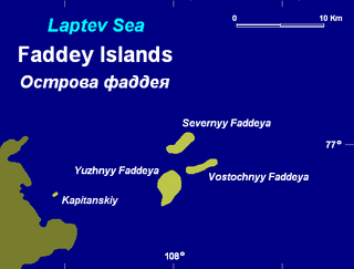
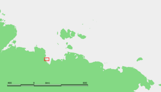
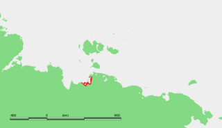
The Faddey Islands is a group of islands in the Laptev Sea, Russia.

The Komsomolskaya Pravda Islands are an archipelago in the far north of the Russian Federation. The islands are uninhabited and are covered with tundra vegetation, shingle and ice.

The Yenisei Gulf is a large and long estuary through which the lower Yenisei River flows into the Kara Sea.

The Saint Peter Islands, also known as Saint Petra Islands or Petra Islands are two islands covered with tundra vegetation, shingle and ice. These islands, as well as some other islands nearby were originally named after Christian Apostles. The climate is Arctic and severe with frequent blizzards in the winter. The sea surrounding these Islands is covered with fast ice most of the year and is obstructed by pack ice even in the summer, so that these islands are merged with the mainland and animals can go across the ice.

The Dunay Islands, or Duunay Aryta, is a group of islands in the Laptev Sea. They are located close to the mouths of the Lena River, off the northwestern shores of the Lena Delta.

Brusneva Island, is a small island in the Laptev Sea. It is located off the eastern side of the Lena delta in the Tiksi Bay, only 5 km ENE of Tiksi. Its length is 2.3 km and its maximum breadth less than 1 km. The name of this island is also spelt as "Brusnova" in some maps.
Muostakh Island, also spelled "Mostakh", is an island in the Buor-Khaya Gulf of the Laptev Sea. It is located off the eastern side of the Lena delta, enclosing the Tiksi Bay, about 35 km ESE of Tiksi.

Yarok Island is an island in the Laptev Sea, a marginal sea of the Arctic Ocean. The island is located off the mouths of the Yana river, only a few kilometres towards the east.
Makar Island is an island in the Laptev Sea. It is located in the bay of the Yana river, about 30 km from the nearest coast to the south, and 21 km north of the Shelonsky Islands.

The Buor-Khaya Gulf or Buor-Khaya Bight is one of the most important gulfs of the Laptev Sea. It is located between the eastern side of the Lena delta on its western side and Cape Buor-Khaya at its NE end.

Cape Buor Khaya, is a headland in the Laptev Sea.
The Ebelyakh Bay or Ebelyakhskaya Bay is a bay in the Laptev Sea. It is located east of the Yana Bay region and southwest of the Laptev Strait.

The Geography of Franz Josef Land refers to an island group belonging to Arkhangelsk Oblast of Russia. It is situated in the Barents Sea of the Arctic, north of Novaya Zemlya and east of Svalbard. At latitudes between 80.0° and 81.9° north, it is the most northerly group of islands associated with Eurasia. The extreme northernmost point is Cape Fligely on Rudolf Island. The archipelago consists of 191 ice-covered islands with a total area of 16,134 km2 (6,229 sq mi). It is currently uninhabited. The archipelago is only 900 to 1,110 km from the North Pole, and the northernmost islands are closer to the Pole than any other land except for Canada's Ellesmere Island and Greenland. The largest island is Zemlya Georga which measures 110 km (68 mi) from end to end. The highest point in the archipelago is on Ostrov Viner-Neyshtadt which reaches 620 m (2,034 ft) above sea level. The central cluster of large islands in the midst of the archipelago forms a compact whole, known as Zichy Land, where islands are separated from each other by very narrow sounds that are frozen most of the year.


