Brusneva Island

Last updated
Location of Brusneva Island in the Tiksi Bay. Siberia BRS.png
Location of Brusneva Island in the Tiksi Bay.

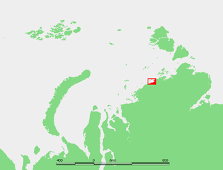
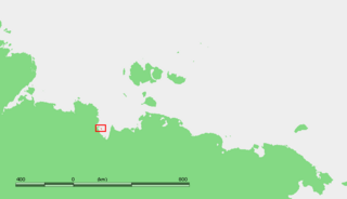
Brusneva Island (Russian : Остров Бруснева, Ostrov Brusneva), is a small island in the Laptev Sea. It is located off the eastern side of the Lena delta in the Tiksi Bay, only 5 km ENE of Tiksi. Its length is 2.3 km and its maximum breadth less than 1 km. The name of this island is also spelt as "Brusnova" in some maps.

Russian language East Slavic language

Russian is an East Slavic language, which is official in the Russian Federation, Belarus, Kazakhstan and Kyrgyzstan, as well as being widely used throughout Eastern Europe, the Baltic states, the Caucasus and Central Asia. It was the de facto language of the Soviet Union until its dissolution on 25 December 1991. Although, nowadays, nearly three decades after the breakup of the Soviet Union, Russian is used in official capacity or in public life in all the post-Soviet nation-states, as well as in Israel and Mongolia, the rise of state-specific varieties of this language tends to be strongly denied in Russia, in line with the Russian World ideology.

Laptev Sea Marginal sea in the Arctic Ocean north of Siberia between the Kara Sea and the East Siberian Sea

The Laptev Sea is a marginal sea of the Arctic Ocean. It is located between the northern coast of Siberia, the Taimyr Peninsula, Severnaya Zemlya and the New Siberian Islands. Its northern boundary passes from the Arctic Cape to a point with co-ordinates of 79°N and 139°E, and ends at the Anisiy Cape. The Kara Sea lies to the west, the East Siberian Sea to the east.

Lena River river in Russia

The Lena is the easternmost of the three great Siberian rivers that flow into the Arctic Ocean. With a mean annual discharge of 588 cubic kilometers per year, it is the second largest of the Arctic rivers. It is the largest river whose catchment is entirely within the Russian territorial boundaries. Permafrost underlies most of the catchment, with 77% of the catchment containing continuous permafrost.

Tiksi Bay, the area where Brusneva Island lies, is subject to severe Arctic weather with frequent gales and blizzards. The sea in the bay is frozen for about nine months every year.

History

In August 1901 Russian Arctic ship Zarya headed across the Laptev Sea, searching for the legendary Sannikov Land (Zemlya Sannikova) but was soon blocked by floating pack ice in the New Siberian Islands. During 1902 the attempts to reach Sannikov Land continued while Zarya was trapped in fast ice. Leaving the ship, Russian Arctic explorer Baron Eduard Toll and three companions vanished forever in November 1902 while travelling away from Bennett Island towards the south on loose ice floes. After its ordeal in the ice, a badly-leaking Zarya was finally moored close to Brusneva Island in Bukhta Tiksi, never to leave the place again. The remaining members of the expedition returned to Saint Petersburg, while Captain Matisen went to Yakutsk.

<i>Zarya</i> (polar ship)

Zarya was a steam- and sail-powered brig used by the Russian Academy of Sciences for a polar exploration during 1900–1903.

Sannikov Land

Sannikov Land was a phantom island in the Arctic Ocean. Its supposed existence became something of a myth in 19th-century Russia.

New Siberian Islands island group in Russia

The New Siberian Islands are an archipelago in the Extreme North of Russia, to the North of the East Siberian coast between the Laptev Sea and the East Siberian Sea north of the Sakha (Yakutia) Republic.

The island was named after Russian Engineer M. I. Brusnev, a member of the Russian Arctic Expedition. Brusnev led one of the two search parties that were dispatched in the spring of 1903 in order to search for ill-fated Baron Eduard Toll. Brusnev's group searched the shores of the New Siberian Islands, while the other, led by Aleksandr Kolchak travelled by whaleboat to Bennett Island. Brusnev found the remains of a mammoth in the island of New Siberia during his unfruitful search for Eduard Toll. [1]

Russians are a nation and an East Slavic ethnic group native to European Russia in Eastern Europe. Outside Russia, notable minorities exist in other former Soviet states such as Belarus, Kazakhstan, Moldova, Ukraine and the Baltic states. A large Russian diaspora also exists all over the world, with notable numbers in the United States, Germany, Brazil, and Canada.

Bennett Island island

Bennett Island is the largest of the islands of the De Long group in the northern part of the East Siberian Sea. The area of this island is approximately 150 square kilometres and it has a tombolo at its eastern end. The highest point of the island is 426 metres high Mount De Long, the highest point of the archipelago.

Mammoth Extinct genus of mammals

A mammoth is any species of the extinct genus Mammuthus, one of the many genera that make up the order of trunked mammals called proboscideans. The various species of mammoth were commonly equipped with long, curved tusks and, in northern species, a covering of long hair. They lived from the Pliocene epoch into the Holocene at about 4,000 years ago, and various species existed in Africa, Europe, Asia, and North America. They were members of the family Elephantidae, which also contains the two genera of modern elephants and their ancestors.

Related Research Articles

Tiksi Urban-type settlement in Sakha Republic, Russia

Tiksi is an urban locality and the administrative center of Bulunsky District in the Sakha Republic, Russia, located on the shore of the Buor-Khaya Gulf of the Laptev Sea, southeast of the delta of the Lena River. As of the 2010 Census, its population was 5,063.

De Long Islands archipelago

The De Long Islands are an uninhabited archipelago often included as part of the New Siberian Islands, lying north east of Novaya Sibir.

Yana River river in Russia

The Yana River, is a river in Sakha in Russia, located between the Lena to the west and the Indigirka to the east.

Belkovsky Island Island in Far Eastern Federal District, Russian Federation

Belkovsky Island is the westernmost island of the Anzhu Islands subgroup of the New Siberian Islands archipelago in the Laptev Sea.

Eduard von Toll Russian explorer

Eduard Gustav Freiherr von Toll, often referred to as Baron von Toll, was a Baltic German geologist and Arctic explorer. He was most notable for the leading Russian polar expedition of 1900–1902 of the legendary Sannikov Land. He was known as Eduárd Vasílʹevich Tollʹ in Russia.

Kotelny Island island

Kotelny Island is part of the Anzhu Islands subgroup of the New Siberian Islands located between the Laptev Sea and the East Siberian Sea in the Russian Arctic. It is administratively and municipally part of Bulunsky District.

Tillo Islands

The Tillo Islands is a group of small islands covered with tundra vegetation. They stretch along the Kara Sea coastal region, right off the bleak coast of Siberia's Taymyr Peninsula. Most of the islands of the group are a mere 3 or 4 km from the continental shore.

Middendorff Bay

The Middendorff Bay, is a deeply indented bay in the shores of the Taymyr Peninsula. It is located southwest of the Nordenskiöld Archipelago in the Kara Sea and it is open towards the west.

Taymyr Island in the Artic off Russia

Taymyr Island, Russian: Остров Таймыр(Ostrov Taymyr), is a large island in the coast of the Kara Sea. Its length is 33 km (21 mi) and its average width about 10 km (6.2 mi). This island is located west of the Taymyr Gulf in an area of skerries right off the western coast of the Taymyr Peninsula. The narrow strait between Taymyr island and the Siberian coast is called Proliv Taymyrskiy It is about 3 km (1.9 mi) wide on average.

Fyodor Matisen lieutenant of the Russian Imperial Navy, hydrographer, and explorer

Fyodor Andreyevich Matisen was an officer of the Russian Imperial Navy, hydrographer, and explorer.

Muostakh Island island in Russia

Muostakh Island, also spelled "Mostakh", is an island in the Buor-Khaya Gulf of the Laptev Sea. It is located off the eastern side of the Lena delta, enclosing the Tiksi Bay, about 35 km ESE of Tiksi.

Russian polar expedition of 1900–1902

The Russian polar expedition of 1900–1902 was commissioned by the Saint Petersburg Academy of Sciences to study the Arctic Ocean north of New Siberian Islands and search for the legendary Sannikov Land. It was led by the Baltic German geologist and Arctic explorer Baron Eduard von Toll on the ship Zarya. Toll and his three assistants vanished in late 1902 while exploring Bennett Island. One of the key members of the expedition was Alexander Kolchak, then a young researcher and lieutenant of the Russian Navy, and later a ruler of Russia. Kolchak also led the rescue mission to find Toll and his crew.

Russian rescue expedition of 1903

The Russian rescue expedition of 1903 was commissioned by the Saint Petersburg Academy of Sciences to rescue the groups of Baron Eduard Toll and Alexei Byalynitsky-Birulya that were left near New Siberian Islands by the Russian polar expedition of 1900–1902. The expedition was organized and led by Alexander Kolchak, then a young researcher and lieutenant of the Russian Navy, and later a ruler of Russia.

References

Coordinates: 71°39′19″N129°03′10″E / 71.6552°N 129.0527°E / 71.6552; 129.0527

Geographic coordinate system Coordinate system

A geographic coordinate system is a coordinate system that enables every location on Earth to be specified by a set of numbers, letters or symbols. The coordinates are often chosen such that one of the numbers represents a vertical position and two or three of the numbers represent a horizontal position; alternatively, a geographic position may be expressed in a combined three-dimensional Cartesian vector. A common choice of coordinates is latitude, longitude and elevation. To specify a location on a plane requires a map projection.