| Mamırlı | |
|---|---|
| Municipality | |
 Mamırlı | |
| Coordinates: 40°19′23″N47°04′38″E / 40.32306°N 47.07722°E Coordinates: 40°19′23″N47°04′38″E / 40.32306°N 47.07722°E | |
| Country | |
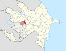
| Rayon | Tartar |
| Elevation | 107 m (351 ft) |
| Population [ citation needed ] | |
| • Total | 1,547 |
| Time zone | AZT (UTC+4) |
| • Summer (DST) | AZT (UTC+5) |
Mamırlı (also, Mamyrly) is a village and municipality in the Tartar Rayon of Azerbaijan. It has a population of 1,547.

Azerbaijan, officially the Republic of Azerbaijan, is a country in the South Caucasus region of Eurasia at the crossroads of Eastern Europe and Western Asia. It is bounded by the Caspian Sea to the east, Russia to the north, Georgia to the northwest, Armenia to the west and Iran to the south. The exclave of Nakhchivan is bounded by Armenia to the north and east, Iran to the south and west, and has an 11 km long border with Turkey in the northwest.