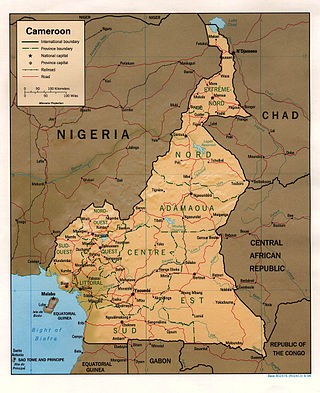
At 475,440 km2 (183,570 sq mi), Cameroon is the world's 53rd largest country. It is slightly larger than the nation of Sweden and the US state of California. It is comparable in size to Papua New Guinea. Cameroon's landmass is 472,710 km2 (182,510 sq mi), with 2,730 km2 (1,050 sq mi) of water.

Gabon is a country in Central Africa, lying along the Atlantic Ocean, just south of the Bight of Biafra.

Guinea is a country on the coast of West Africa and is bordered by Guinea-Bissau, Senegal, Mali, Ivory Coast, Liberia, and Sierra Leone.

The Marshall Islands consist of two archipelagic island chains of 30 atolls and 1,152 islands, which form two parallel groups—the "Ratak" (sunrise) chain and the "Ralik" (sunset) chain. The Marshalls are located in the North Pacific Ocean and share maritime boundaries with Micronesia and Kiribati. Two-thirds of the nation's population lives in the capital of Majuro and the settlement of Ebeye. The outer islands are sparsely populated due to lack of employment opportunities and economic development.

Mali is a landlocked nation in West Africa, located southwest of Algeria, extending south-west from the southern Sahara Desert through the Sahel to the Sudanian savanna zone. Mali's size is 1,240,192 square kilometers.

Kindia is the fourth largest city in Guinea, located about 85 miles (137 km) northeast of the nation's capital, Conakry. Its estimated population in 2008 was 181,126. Kindia serves as the capital and largest city of Kindia Prefecture and Kindia Region. It also functions as a sub-prefecture of Guinea.

Kankan is the largest city in Guinea in land area, and the third largest in population, with a population of 198,013 people as of 2020. The city is located in eastern Guinea about 555 kilometres east of the national capital Conakry.

Labé is the main city and administrative capital of the Fouta Djallon region of Guinea. It has a population of about 200,000. It is the second largest city in the country after the capital Conakry in terms of economic importance. Labé is situated some 450 kilometres or 280 miles northeast of Conakry close to the geographic centre of Guinea.
Faranah is a town and sub-prefecture in central Guinea, lying by the River Niger. As of 2014 it had a population of 78,108 people. The town is mainly inhabited by the Malinke people.
Boké is the capital city of Boké Prefecture within the Boké Region of Lower Guinea near the border with Guinea-Bissau. It is also a sub-prefecture of Guinea. Located along the Rio Nuñez which flows to its not-too-distant mouth on the Atlantic Ocean, Boké is a port. It is known for the Boké Museum, formerly a slave fort. The town is served by Boké Baralande Airport. As of 2014 the city and surrounding sub-prefecture had a population of 61,449 people.

Kédougou is a town in the Kédougou Region of south-eastern Senegal near the border with Mali and Guinea. It lies at an elevation of 167 m (548 ft) above sea level.

Koundara is a town in northwestern Guinea, near the borders of Guinea-Bissau and Senegal. It is the capital of Koundara Prefecture. The town is served by Sambailo Airport. As of 2014 it had a population of 27,433 people.

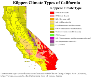
The climate of California varies widely from hot desert to alpine tundra, depending on latitude, elevation, and proximity to the Pacific Coast. California's coastal regions, the Sierra Nevada foothills, and much of the Central Valley have a Mediterranean climate, with warmer, drier weather in summer and cooler, wetter weather in winter. The influence of the ocean generally moderates temperature extremes, creating warmer winters and substantially cooler summers in coastal areas.

Pita , is a town in the Fouta Djallon highlands of Guinea. It is the capital and largest urban center of the Pita Prefecture.

The climate of Romania is continental, transitioning into humid subtropical on the eastern coast, influenced by polar intrusions, and therefore characterized by harsh winters. The mountain ranges of the Carpathian arc have a cool mountain climate with high humidity throughout the year.

The climate of Russia is formed under the influence of several determining factors. The enormous size of the country and the remoteness of many areas from the sea result in the dominance of the continental climate, which is prevalent in European and Asian Russia except for the tundra and the extreme southwest. Mountains in the south obstructing the flow of warm air masses from the Indian Ocean and the plain of the west and north makes the country open to Arctic and Atlantic influences. Russia's climate, despite its enormous geographical extent, is generally warm to hot in the summer and cold to very cold in the winter, with snow cover typically present over the vast majority of the country's territory in the winter months, with the exception of the country's southernmost territories, the North Caucasus. Russia's far northeast, subject to an extreme subarctic climate, experiences the coldest winters of any permanently settled region in the world, with Yakutsk, the capital of the Sakha Republic, being the world's coldest major city and Oymyakon, also in the Sakha Republic, being the world's coldest permanently inhabited settlement.

The climate of New England varies greatly across its 500-mile (800 km) span from northern Maine to southern Connecticut.


