
Badrinath is a town and nagar panchayat in Chamoli district in the state of Uttarakhand, India. It is a Hindu holy place, and is one of the four sites in India's Char Dham pilgrimage. It is also part of India's Chota Char Dham pilgrimage circuit and gets its name from the Badrinath Temple.
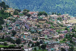
Joshimath, also known as Jyotirmath, is a town and a municipal board in Chamoli District in the Indian state of Uttarakhand. Located at a height of 6,150 feet, it is a gateway to several Himalayan mountain climbing expeditions, trekking trails and pilgrim centres like Badrinath. It is home to one of the four cardinal pīthas established by Adi Shankara.

Chamoli district is a district of the Uttarakhand state of India. It is bounded by the Tibet region to the north, and by the Uttarakhand districts of Pithoragarh and Bageshwar to the east, Almora to the south, Pauri Garhwal to the southwest, Rudraprayag to the west, and Uttarkashi to the northwest. The administrative headquarters of Chamoli district is in Gopeshwar.

The Alaknanda is a turbulent Himalayan river in the Indian state of Uttarakhand and one of the two headstreams of the Ganges, the major river of Northern India and the holy river of Hinduism. In hydrology, the Alaknanda is considered the source stream of the Ganges on account of its greater length and discharge; however, in Hindu tradition and culture, the other headstream, the Bhagirathi, is considered the source stream.
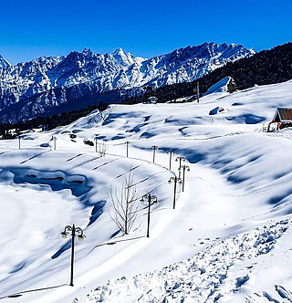
Auli is in Chamoli district in the Himalayan mountains of Uttarakhand, India. Auli, also known as Auli Bugyal, in Garhwali, which means "meadow", is located at an elevation of 2,800 metres (9,200 ft) above sea level. Between June and October, the valley has one of highest numbers of flower species found anywhere in the world, with 520 species of high-altitude plants, 498 of which are flowering plants with significant populations of endangered species.

Devprayag is a town and a nagar panchayat, near New Tehri city in Tehri Garhwal District in the state of Uttarakhand, India, and is the final one of the Panch Prayag of Alaknanda River where Alaknanda meets the Bhagirathi river and both rivers thereafter flow on as the Ganges river or Ganga.
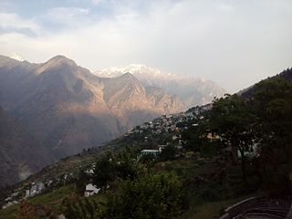
Chamoli Gopeshwar is a township in the Garhwal hills and a municipal board within Chamoli district. It is the administrative headquarters of the Chamoli District of Uttarakhand in India. Located 1,550 m (5,090 ft) above sea level, it is famous for its weather and its temple Chamoli Gopeshwar is known for his very beautiful temple "Gopinath" one can definitely experience the feeling of being there in Gopinath. Chamoli Gopeshwar has a very beautiful kund that is Vaitrani.

Gauchar is a Hill Town sort of a valley town located in Karnaprayag tehsil within Chamoli district of Uttarakhand state in India. Gauchar is situated on the left bank of river Alaknanda and is en route to the celebrated holy destination of Badrinath. It is well known for being one of the cleanest place in country. It has previously topped Swachta sarvekshan best ganga town award. Situated at an altitude of 800 metres (2,620 ft) above the sea level, Gauchar is surrounded by seven mountains. Gauchar is well known for its historic trade fair and airstrip. Gauchar town known for its great work to curb loss of lives in 2013 flood disaster of Uttarakhand. This town is unique in terms of its geographical location and topography. Gauchar is located on one of the largest pieces of flatland in this mountainous region of Uttarakhand. Education institution in Gauchar includes a beautiful Kendriya Vidyalaya adjacent to the main playground.

Karnaprayag is a town and municipal board in the Chamoli District in the Indian state of Uttarakhand. Karnaprayag is one of the Panch Prayag of Alaknanda River, situated at the confluence of the Alaknanda and Pindar River.

Nandaprayag is a town and a nagar panchayat in Chamoli district in the Indian state of Uttarakhand. Nandaprayag is one of the Panch Prayag of Alaknanda River and lies at the confluence of the Alaknanda River and Nandakini River. Nandaprayag was once the capital of the Yadu kingdom.

Rudraprayag is a city and a municipality in Rudraprayag district in the Indian state of Uttarakhand. Rudraprayag is one of the Panch Prayag of Alaknanda River, the point of confluence of rivers Alaknanda and Mandakini. Kedarnath, a Hindu holy city is located 86 km from Rudraprayag. The man-eating Leopard of Rudraprayag hunted and written about by Jim Corbett dwelled here.

Badarinath or Badarinarayana Temple is a Hindu temple dedicated to Vishnu. It is situated in the town of Badrinath in Uttarakhand, India. The temple is also one of the 108 Divya Desams dedicated to Vishnu—holy shrines for Vaishnavas—who is worshipped as Badrinath. It is open for six months every year, because of extreme weather conditions in the Himalayan region. The temple is located in Garhwal hill tracks in Chamoli district along the banks of Alaknanda River. It is one of the most visited pilgrimage centers of India, having recorded 2.8 million visits in just 2 months in 2022. It is one of the Char Dham pilgrimage sites.

This article is about the old number of Delhi-Meerut-Roorkee-Haridwar-Badrinath National Highway.
Mana Pass or Chongnyi La is one of the highest vehicle-accessible passes in the world, containing a road constructed in the 2005-2010 period for the Indian military by the Border Roads Organisation and visible on 2011 imagery on visual globe systems such as Google Earth. The well-graded gravel-dirt road is higher on the Indian side than the new road on the Tibetan side, and rises to 5,610 metres (18,406 ft) on the Indian side of the border, 250 m west of the low point of the 5,632 metres (18,478 ft) Mana Pass SRTM.
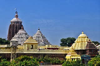
The Char Dham, also rendered the Chatur Dhama is a set of four pilgrimage sites in India. It is believed that visiting these sites helps achieve moksha (salvation). The four Dhams are, Badrinath, Dwarka, Puri and Rameswaram. It is believed that every Hindu should visit the Char Dhams during one's lifetime. The Char Dham as defined by Adi Shankara consists of four Hindu pilgrimage sites. These main 'dhamas' are the shrines of Vishnu and Rameshwaram is a shrine of Shiva. All the 'dhamas' are related to four epochs,(1) Dham of Satyuga- Badrinath, Uttarakhand (2) Dham of Tretayuga -Rameswaram, Tamil Nadu (3) Dham of Dwaparayuga - Dvaraka, Gujarat (4) Dham of Kaliyuga - Jagannatha Puri, Odisha.
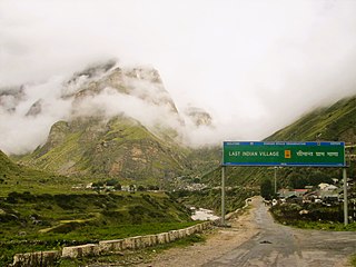
Bhotiyas are people of presumed Tibetan heritage that live along the Indo-Tibetan border in the upper reaches of the Great Himalayas, at elevations ranging from 6,500 feet (2,000 m) to 13,000 feet (4,000 m). In Uttarakhand, they inhabit seven river valleys, three in the Garhwal division and four in the Kumaon division. Their main traditional occupation used to be Indo-Tibetan trade, with limited amounts of agriculture and pastoralism. The customary Indo-Tibetan trade drastically stopped following the 1962 Sino-Indian war, and was resumed in the early 1990s under state-regulated mechanisms. These days, medicinal and aromatic plant collection is a major livelihood among this group, alongside by out-migration for education and jobs. Transhumance and pastoralism have drastically reduced in prevalence among this group too. They follow Hinduism and Buddhism and traditionally speak West Himalayish languages.

Saraswati River is a tributary of Alaknanda River flowing in Uttarakhand State, India. It joins Alaknanda River at Keshav Prayag, near Mana village, Badrinath. The confluence of rivers Alaknanda and Bhagirathi at Devprayag in the state of Uttarakhand, forms and flows as river Ganga or The Ganges from the point forward. A natural stone bridge, named "Bhim Pul", lays across flowing Saraswati river, making a passage towards Vasudhara falls and Satopanth Lake. It is believed by locals that Bhim Pul is a rock bridge founded by Bhima of Mahabharatha, to help Draupadi to cross the rivulet.

National Highway 7 is a highway connecting Fazilka (Punjab) to Mana (Uttarakhand) in India. It passes through the Indian states of Punjab, Haryana, Himachal Pradesh, and Uttarakhand.

Char Dham National Highway, is an under construction two-lane express National Highway with a minimum width of 10 metres in the Indian state of Uttarakhand under Char Dham Pariyojana. The under construction highway will complement the under-construction Char Dham Railway by connecting the four holy places in Uttarakhand states namely Badrinath, Kedarnath, Gangotri and Yamunotri. The project includes 900 km national highways which will connect whole of Uttarakhand state.

Mandal is a village in the Garhwal Himalayas of Uttarakhand, India.

