
The Gulf of Ob is a bay of the Arctic Ocean, located in Northern Russia at the mouth of the Ob River. It is the world's longest estuary.

The Manawatu River, often spelled Manawatū in New Zealand English, is a major river of the lower North Island of New Zealand.

Foxton Beach is a small settlement in the Horowhenua District of the Manawatu-Wanganui region of New Zealand's North Island. It is located on the South Taranaki Bight at the mouth of the Manawatu River, 35 kilometres southwest of Palmerston North, and six kilometres west of Foxton. Foxton Beach has a permanent population of around 2000 people. The town is a popular holiday destination due mainly to its beach and the bird sanctuary at the Manawatu Estuary. Most of Foxton Beach is made up of holiday homes.
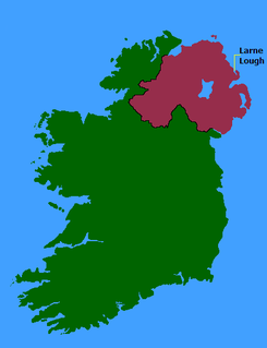
Larne Lough is a sea lough or inlet in County Antrim, Northern Ireland. The lough lies between Islandmagee and the mainland. At its mouth is the town of Larne. It is designated as an area of special scientific interest, a special protection area, and a Ramsar site to protect the wetland environment, particularly due to the presence of certain bird species and shellfish.

The Ythan Estuary is the tidal component of the Ythan River, emptying into the North Sea 19 kilometres (12 mi) north of Aberdeen, Scotland. The estuary’s tidal action extends a 7 kilometres (4.3 mi) inland and has characteristic widths of between 250 metres (820 ft) and 780 metres (2,560 ft). Besides the tidal channel there are interfaces to the upland dunes including mudflats, sand beaches and shingle flats. Reaches of salt marsh occur, but they are primarily near the Waterside Bridge and the mouth of the Tarty Burn, a small tributary river. Based upon the habitat of the moorland bordering the east of the Ythan River near the mouth, this estuary is the most significant coastal moorland in the northern United Kingdom.

Deben Estuary is a 981.1 hectare biological Site of Special Scientific Interest (SSSI) covering the River Deben and its banks 12 kilometres from its mouth north of Felixstowe to Woodbridge in Suffolk. It is a Ramsar internationally important wetland site and a Special Protection Area under the European Union Directive on the Conservation of Wild Birds. It is also in the Suffolk Coast and Heaths Area of Outstanding Natural Beauty. It partly overlaps two geological SSSIs, Ferry Cliff, Sutton and Ramsholt Cliff.
Lake Man is an area of wetlands in Okinawa that is located between the cities of Naha and Tomigusuku, and within Manko Park. Despite being called "Lake Man", it is in fact a wetland and not a lake. Lake Man covers .11 square kilometres (0.042 sq mi).
The Tabusintac Lagoon and River Estuary is a wetland in Alnwick Parish, Northumberland County, in north-eastern New Brunswick, Canada. It was classified as a wetland of international importance on June 10, 1993. It is also a globally significant Important Bird Area for the population of common terns, and shorebirds in general, that it supports. Primarily a shallow coastal estuary with gentle slopes, the 50 km2 site is underlain by various sedimentary rocks, including red sandstone and shale. The lagoon system is protected from the Gulf of Saint Lawrence by a constantly shifting barrier beach and dune system that frequently blocks commonly used navigation channels. It attains an elevation of no more than 8 m above sea level.
New Zealand has several notable wetlands but 90% of wetland areas have been lost following European settlement.

The Grand Codroy Estuary is a 925 hectare wetland on the southwestern coast of the island of Newfoundland in Canada, approximately 30 km north of Port aux Basques. It is "[one] of the most productive of Newfoundland's few estuarine wetland sites", and is "the province's most important wetland". It is a Wetland of International Importance under the Ramsar Convention, receiving this designation on May 27, 1987. To the south is a globally significant Important Bird Area.

The Vasse-Wonnerup Estuary is an estuary in the South West region of Western Australia close to the town of Busselton. The estuary is listed with DIWA. It was also recognised as a wetland of international importance under the Ramsar Convention on 7 June 1990 when an area of 1,115 ha was designated Ramsar Site 484 as an important dry-season habitat for waterbirds. It is also the main part of the 2,038 ha (5,040-acre) Busselton Wetlands Important Bird Area.

The Kothduwa temple, or Koth Duwa Raja Maha Viharaya, is a Buddhist temple located on Kothduwa Island on the Madu Ganga in southern Sri Lanka. The island is located in Galle District of the Southern Province approximately 35 km (22 mi) north of Galle and 88 km (55 mi) south of Colombo.
The Port Phillip Bay and Bellarine Peninsula Ramsar Site is one of the Australian sites listed under the Ramsar Convention as a wetland of international importance. It was designated on 15 December 1982, and is listed as Ramsar Site No.266. Much of the site is also part of either the Swan Bay and Port Phillip Bay Islands Important Bird Area or the Werribee and Avalon Important Bird Area, identified as such by BirdLife International because of their importance for wetland and waterbirds as well as for orange-bellied parrots. It comprises some six disjunct, largely coastal, areas of land, totalling 229 km2, along the western shore of Port Phillip and on the Bellarine Peninsula, in the state of Victoria. Wetland types protected include shallow marine waters, estuaries, freshwater lakes, seasonal swamps, intertidal mudflats and seagrass beds.

The Hunter Estuary Wetlands comprise a group of associated wetlands at and near the mouth of the Hunter River in the city of Newcastle, New South Wales, Australia. Some 30 km2 of the wetlands has been recognised as being of international importance by designation under the Ramsar Convention. It was listed on 21 February 1984 as Ramsar site 287. A larger area of the wetlands has been identified by BirdLife International as an Important Bird Area (IBA). The wetlands are recognised as the most important area in New South Wales for waders, or shorebirds.

Lavinia State Reserve, formerly Lavinia Nature Reserve, is a 68 km2 protected area on King Island, lying at the western end of Bass Strait and belonging to the Australian state of Tasmania.
The Lagoas de Pedra Badejo is an area of wetlands on the island of Santiago, Cape Verde. It is a 666-hectare (1,650-acre) site comprising two coastal lagoons at the estuaries of the rivers Ribeira dos Picos and Ribeira Seca, and the entire basin of the latter, including the reservoir Barragem de Poilão. It lies south of the town of Pedra Badejo, on the north-east coast of the island. The lagoons are of great ecological value for birds as they contain fresh or only slightly brackish water. They have been recognised as a wetland of international importance by designation under the Ramsar Convention since 2005.

The Crouch and Roach Estuaries are a 1729 hectare biological Site of Special Scientific Interest (SSSI) at the mouth of the Crouch and Roach rivers in Essex. The Crouch part of the SSSI stretches from near Battlesbridge to Foulness Island, and the Roach from Rochford to the junction with the Crouch. Part of the site is in the Mid-Essex Coast Special Protection Area under the EC Directive on the Conservation of Wild Birds, and a Ramsar wetland site of international importance. It is also part of the Essex Estuaries Special Area of Conservation. An area of 65 hectares is managed by the Essex Wildlife Trust as the Lion Creek and Lower Raypits nature reserve and 8 hectares at Woodham Fen, both of which are managed by the Essex Wildlife Trust. A small area is also a geological SSSI, The Cliff, Burnham-on-Crouch.

The Divjakë-Karavasta National Park is a national park in western Albania, sprawling across the Myzeqe Plain in the direct proximity to the Adriatic Sea. The park spans a territory of 222.3 square kilometres (22,230 ha) containing remarkable features such as wetlands, salt marshes, coastal meadows, floodplains, woodlands, reed beds, forests and estuaries. Because of the park's important and great availability of bird and plant species, it has been identified as an important Bird and Plant Area of international importance.
Orwell Estuary is a 1,335.7 hectare biological Site of Special Scientific Interest which stretches along the River Orwell and its banks between Felixstowe and Ipswich in Suffolk. It is part of the Stour and Orwell Estuaries Ramsar site internationally important wetland site and Special Protection Area under the European Union Directive on the Conservation of Wild Birds. It is also in the Suffolk Coast and Heaths Area of Outstanding Natural Beauty.

South Thames Estuary and Marshes is a 5,289-hectare (13,070-acre) biological Site of Special Scientific Interest which stretches between Gravesend and the mouth of the River Medway in Kent. Part of it is a Nature Conservation Review site, Grade I, and part is a Royal Society for the Protection of Birds nature reserve. It is part of the Thames Estuary and Marshes Ramsar internationally important wetland site and Special Protection Area under the European Union Directive on the Conservation of Wild Birds.
