This article needs additional citations for verification .(October 2020) |
Mandal | |
|---|---|
Village | |
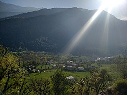 Mandal Village | |
 Mandal Location in Uttarakhand, India | |
| Coordinates: 30°27′18″N79°16′30″E / 30.455°N 79.275°E | |
| Country | |
| State | Uttarakhand |
| District | Chamoli |
| Government | |
| • Type | Gram Panchayat |
| Area | |
• Total | 1.2 km2 (0.46 sq mi) |
| Elevation | 1,500–1,700 m (4,900–5,600 ft) |
| Population (2011) [1] | |
• Total | 452 |
| Languages | |
| • Official | Hindi |
| Time zone | UTC+5:30 (IST) |
| PIN | 246401 [2] |
| Vehicle registration | UK-11 |
| Website | uk |
Mandal [3] is a village in the Garhwal Himalayas in Chamoli tensil, Chamoli district, Uttarakhand, India.
Contents
It is situated 23 km away from sub-district headquarters Chamoli and 13 km away from district headquarters Gopeshwar. [4]