Mandera triangle

Last updated

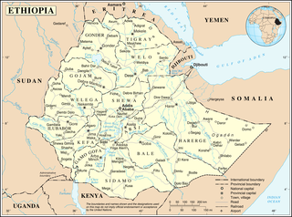
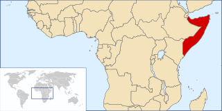
The Mandera triangle is a geographical region in Eastern Africa where the countries of Kenya, Ethiopia, and Somalia meet. [1] The tri-border region is centered on the city of Mandera in Mandera County and corresponds with the Juba and Shabelle river basins. [2] [3]

East Africa Eastern region of the African continent

East Africa or Eastern Africa is the eastern region of the African continent, variably defined by geography. In the United Nations Statistics Division scheme of geographic regions, 20 territories make up Eastern Africa:

Country distinct region in geography; a broad term that can include political divisions or regions associated with distinct political characteristics

A country is a region that is identified as a distinct entity in political geography. A country may be an independent sovereign state or part of a larger state, as a non-sovereign or formerly sovereign political division, or a geographic region associated with sets of previously independent or differently associated people with distinct political characteristics. Regardless of the physical geography, in the modern internationally accepted legal definition as defined by the League of Nations in 1937 and reaffirmed by the United Nations in 1945, a resident of a country is subject to the independent exercise of legal jurisdiction. There is no hard and fast definition of what regions are countries and which are not.

Kenya republic in East Africa

Kenya, officially the Republic of Kenya, is a country in Africa with 47 semiautonomous counties governed by elected governors. At 580,367 square kilometres (224,081 sq mi), Kenya is the world's 48th largest country by total area. With a population of more than 52.2 million people, Kenya is the 27th most populous country. Kenya's capital and largest city is Nairobi while its oldest city and first capital is the coastal city of Mombasa. Kisumu City is the third largest city and a critical inland port at Lake Victoria. Other important urban centres include Nakuru and Eldoret.

Contents

The residents of the area are mainly ethnic Somalis. [4] Pastoralists routinely move across the various borders while seeking water and pasture for their herds. [5] Experiencing large-scale violence as a result of the civil strife in Somalia, engagements between the Ethiopian military and Somali insurgents, inter-clan warfare, livestock raids between rival herders, targeted attacks, and frequent banditry, the United States Department of State has labeled the area "one of the most conflict-prone areas in the world". [2] It has been reported that weapons shipments from Yemen arrive in Somalia, then make their way across the Mandera triangle prior to being moved across the rest of the African continent. [1]

Pastoralism branch of agriculture concerned with the raising of livestock

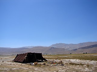
Pastoralism is the branch of agriculture concerned with the raising of livestock. It is animal husbandry: the care, tending and use of animals such as cattle, camels, goats, yaks, llamas, reindeer, horses and sheep.

Water chemical compound

Water is a transparent, tasteless, odorless, and nearly colorless chemical substance, which is the main constituent of Earth's streams, lakes, and oceans, and the fluids of most living organisms. It is vital for all known forms of life, even though it provides no calories or organic nutrients. Its chemical formula is H2O, meaning that each of its molecules contains one oxygen and two hydrogen atoms, connected by covalent bonds. Water is the name of the liquid state of H2O at standard ambient temperature and pressure. It forms precipitation in the form of rain and aerosols in the form of fog. Clouds are formed from suspended droplets of water and ice, its solid state. When finely divided, crystalline ice may precipitate in the form of snow. The gaseous state of water is steam or water vapor. Water moves continually through the water cycle of evaporation, transpiration (evapotranspiration), condensation, precipitation, and runoff, usually reaching the sea.

Pasture land used for grazing

Pasture is a concrete spatial area where farmers keep livestock for grazing.

See also

Geography of Ethiopia

Ethiopia is located in the Horn of Africa. It is bordered by Eritrea to the north, Djibouti and Somalia to the east, Sudan and South Sudan to the west, and Kenya to the south. Ethiopia has a high central plateau that varies from 1,290 to 3,000 m above sea level, with the highest mountain reaching 4,533 m (14,872 ft).

Geography of Kenya

The geography of Kenya is diverse, varying amongst Kenya's 47 Counties. Kenya has a coastline on the Indian Ocean, which contains swamps of East African mangroves. Inland are broad plains and numerous hills.

Geography of Somalia

Somalia is a country located in the Horn of Africa. It is bordered by Ethiopia to the west, Djibouti to the northwest, the Gulf of Aden to the north, the Somali Sea and Guardafui Channel to the east, and Kenya to the southwest. With a land area of 637,657 square kilometers, Somalia's terrain consists mainly of plateaus, plains and highlands. Its coastline is more than 3,333 kilometers in length, the longest of mainland Africa and the Middle East. It has been described as being roughly shaped "like a tilted number seven".

Related Research Articles

Greater Somalia area in East Africa where ethnic Somalis mostly live

Greater Somalia comprises the regions in or near the Horn of Africa in which ethnic Somalis live and have historically inhabited. The territory historically encompassed British Somaliland, Italian Somaliland, French Somaliland, the Ogaden in the Ethiopian Empire and the Northern Frontier District in the Colony and Protectorate of Kenya. At the present day, it encompasses Somalia, eastern Djibouti, the Somali region and Dire Dawa in Ethiopia, and the Lamu, Garissa, Wajir and Mandera Counties in Kenya.

Somali Civil War civil war taking place in Somalia since 1991

The Somali Civil War is an ongoing civil war taking place in Somalia. It grew out of resistance to the military junta led by Siad Barre during the 1980s. By 1988–90, the Somali Armed Forces began engaging various armed rebel groups, including the Somali Salvation Democratic Front in the northeast, the Somali National Movement in the northwest, and the United Somali Congress in the south. The clan-based armed opposition groups eventually managed to overthrow the Barre government in 1991.

In 2006, an acute shortage of food affected the countries in the Horn of Africa, as well as northeastern Kenya. The United Nations's Food and Agriculture Organization (FAO) estimated on January 6, 2006, that more than 11 million people in these countries may be affected by an impending widespread famine, largely attributed to a severe drought, and exacerbated by military conflicts in the region.

Ilemi Triangle

The Ilemi Triangle is an area of disputed land in East Africa. Arbitrarily defined, it measures between 10,320 and 14,000 square kilometres. Named after Anuak chief Ilemi Akwon, the territory is claimed by South Sudan and Kenya and borders Ethiopia. Despite use and raids by tribes within Ethiopia, the Ethiopian government has never made an official claim on any of the Ilemi and in fact agreed that the land was all Sudanese in the 1902, 1907, and 1972 treaties.

Mandera City in Kenya

Mandera is the capital of Mandera County in the former North Eastern Province of Kenya. It is situated at around 3°55′N41°50′E, near the borders with Somalia and Ethiopia.

Various international and local diplomatic and humanitarian efforts in the Somali Civil War have been in effect since the conflict first began in the early 1990s. The latter include diplomatic initiatives put together by the African Union, the Arab League and the European Union, as well as humanitarian efforts led by the Office for the Coordination of Humanitarian Affairs (OCHA), UNICEF, the World Food Programme (WFP), the Puntland Maritime Police Force (PMPF) and the Somali Red Crescent Society (SRCS).

Mohammed Said Hersi Morgan Somali military and faction leader

Mohammed Said Hersi Morgan is a Somali military and faction leader. He is the son-in-law of Siad Barre and Minister of Defense of Somalia. Said Hersi. His military campaign in Southern Somalia in 1992 was one of the main causes of the famine in Somalia.

Battle of Ras Kamboni

The Battle of Ras Kamboni was a battle in the Somali Civil War (2006–2009) fought by the Islamic Courts Union (ICU) and affiliated militias against Ethiopian and the Somali Transitional Federal Government (TFG) forces for control of Ras Kamboni, a town near the Kenyan border which once served as a training camp for the militant Islamist group Al-Itihaad al-Islamiya.

2007–2008 Ethiopian crackdown in Ogaden

The 2007–2008 Ethiopian crackdown in Ogaden was a military campaign by the Ethiopian Army against the Ogaden National Liberation Front (ONLF). The crackdown against the guerrillas began after they killed 74 people in an attack on a Chinese-run oil exploration field in April 2007.

Outline of Somalia Overview of and topical guide to Somalia

The following outline is provided as an overview of and topical guide to Somalia:

Insurgency in Ogaden

The Insurgency in Ogaden is an ongoing separatist insurgency, waged by the Ogaden National Liberation Front (ONLF) against the Ethiopian government. The war began in 1994 when the ONLF attempted to recreate the Greater Somalian state by unifying Ethiopia's Somali Region with Somalia, or form their own independent state.

El Wak, Kenya Place in Kenya

El Wak, also Elwak is a town in Kenya, on the International border with Somalia.

Somali Civil War (2009–present) present phase of the Somali Civil War, which is concentrated in southern Somalia

The 2009–present phase of the Somali Civil War is concentrated in southern Somalia. It began in early February 2009 with the conflict between the forces of the Federal Government of Somalia, assisted by African Union peacekeeping troops, and various militant terrorist groups and factions. The violence has displaced thousands of people in the southern part of the country. The conflict has also seen fighting between the Sufi Ahlu Sunna Waljama'a and Al-Shabaab.

Between July 2011 and mid-2012, a severe drought affected the entire East Africa region. Said to be "the worst in 60 years", the drought caused a severe food crisis across Somalia, Djibouti, Ethiopia and Kenya that threatened the livelihood of 9.5 million people. Many refugees from southern Somalia fled to neighboring Kenya and Ethiopia, where crowded, unsanitary conditions together with severe malnutrition led to a large number of deaths. Other countries in East Africa, including Sudan, South Sudan and parts of Uganda, were also affected by a food crisis.

Mandera Airport airport in Mandera, Kenya

Mandera Airport is an airport in Mandera, Kenya.

A pastoral society is a social group of pastoralists, whose way of life is based on pastoralism, and is typically nomadic. Daily life is centered upon the tending of herds or flocks.

Suftu Town in Somali, Ethiopia

Suftu, also known as Melka Suftu or Melka Softu, is a town in the Liben Zone of Ethiopia. It is located near the border with southern Somalia and the Mandera County in Kenya. Other towns in Liben Zone inclusde Dolo and Sathe.

Rhamu Town in Kenya

Rhamu is a town in the Mandera County of Kenya. It sits across the Dawa River from the town of Sathe, in Ethiopia, at the international border between the two countries.

References

  1. 1 2 Ward, Olivia (March 1, 2009). "Somalia a land of chaos, awash in weapons". TheStar.com. Toronto Star. Retrieved August 28, 2009.
  2. 1 2 U.S. Department of State, Humanitarian Information Unit. WebVISTA Prototype 1: Greater Mandera Triangle Conflict Incident Vista. Retrieved August 28, 2009.
  3. Library of Congress Map Collection. Retrieved August 28, 2009.
  4. Human Rights Watch. Bring the Gun or You'll Die: Torture, Rape, and Other Serious Human Rights Violations by Kenyan Security Forces in the Mandera Triangle. June 29, 2009. Retrieved August 28, 2009.
  5. USAID/East Africa. Regional Enhanced Livelihood in Pastoral Areas (RELPA) [ permanent dead link ] Retrieved August 28, 2009.


Coordinates: 3°55′N41°50′E / 3.917°N 41.833°E / 3.917; 41.833

Geographic coordinate system Coordinate system

A geographic coordinate system is a coordinate system that enables every location on Earth to be specified by a set of numbers, letters or symbols. The coordinates are often chosen such that one of the numbers represents a vertical position and two or three of the numbers represent a horizontal position; alternatively, a geographic position may be expressed in a combined three-dimensional Cartesian vector. A common choice of coordinates is latitude, longitude and elevation. To specify a location on a plane requires a map projection.