
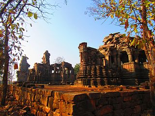
Mandi district is one of the central districts of Himachal Pradesh state in northern India. The town of Mandi is the headquarters of the district.
Panna district is a district of the Sagar Division, within the Madhya Pradesh state in central India. The town of Panna is the district headquarters.
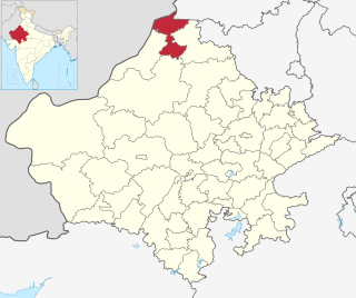
Sri Ganganagar district is the northernmost district of Rajasthan state in western India.
Hailymandi is a town and a municipal council in Gurgaon district in the Indian state of Haryana. It was the market town of the erstwhile Pataudi State before Indian independence. Nearby is the temple of 'Baba Hardeva'.

Phagi is a tehsil and a panchayat samiti, near city of Jaipur in Jaipur district in the state of Rajasthan, India. It has an average elevation of 383 m (1,257 ft). Phagi is also one of the Town in Phagi Tehsil in Dudu District. Phagi is located on the intersection of SH2 and SH12 of Rajasthan.
Madhorajpura, is an ILRC and village in Phagi Tahsil in Jaipur district, Rajasthan. It has a population of around 5000. Madhorajpura has eight patwar circles - Gopalpura, Chandma Kalan, Didawata, Dosara, Beechi, Bhankarota, Madhorajpura and Sehdariya
Mandor is an ILRC and village in Phagi Tehsil in Jaipur district, Rajasthan.
Shankarpura is a patwar circle and village in the northwest region of Phagi Tehsil in Jaipur district, Rajasthan, India. Shankarpura is also a patwar circle for nearby village, Chainpura @ Bharatpura.
Keriya is a patwar circle and village in ILRC Nimera in Phagi Tehsil in Jaipur district, Rajasthan. Keriya is also a patwar circle for nearby villages, Kanwarpura, Gokulpura and Madanpura.
Kishorpura is a patwar circle and village in ILRC Nimera in Phagi Tehsil in Jaipur district, Rajasthan. Kishorpura is also a patwar circle for nearby villages, Beer Ramchandrapura, Bimalpura, Mohanpura Rajawatan, Ramchandrapura and Lakhawas.
Parwan is a patwar circle and village in ILRC Nimera in Phagi Tehsil in Jaipur district, Rajasthan. Parwan is also a patwar circle for nearby villages, Khandooj, Dhunwaliya, Panwasoo Khera, Barh Mordi and Mordi.
Lasariya is a patwar circle and village in ILRC Nimera in Phagi Tehsil in Jaipur district, Rajasthan. Lasariya is also a patwar circle for nearby village, Palri.
Sameliya is a patwar circle and village in ILRC Nimera in Phagi Tehsil in Jaipur district, Rajasthan. Sameliya is also a patwar circle for nearby villages, Chandama Khurd and Mandap.
Hatheli is a patwar circle and village in ILRC Nimera in Phagi Tehsil in Jaipur district, Rajasthan. Hatheli is also a patwar circle for nearby villages, Nathmalpura and Ratanpura.
Rampura Railway is a village in Mandi patwar circle in Phagi Tehsil in Jaipur district, Rajasthan.
Mohanpura Ranwa is a village in Mandi patwar circle in Phagi tehsil in Jaipur district, Rajasthan.
Gopalpura is a patwar circle and village in ILRC Madhorajpura in Phagi tehsil in Jaipur district, Rajasthan. Gopalpura is also a patwar circle for nearby villages, Ramsinghpura and Shri Ramjipura.
Didawata is a patwar circle and village in ILRC Madhorajpura in Phagi tehsil in Jaipur district, Rajasthan. Didawata is also a patwar circle for nearby villages, Bhanpura, Mukand Pura, Sangrampura, Hanootiya Kalan and Hanootiya Khurd.
Mandi is a large village in Phillaur tehsil of Jalandhar District of Punjab State, India. The village is administrated by Sarpanch Jarnail singh dhillon(also elected as block samiti pardhan of nearby 5 villages) who is elected representative of the village. It is 1 km away from census town and postal head office Apra. The village is 47.3 km from Jalandhar, 15 km from Phillaur and 117 km away from state capital Chandigarh.

