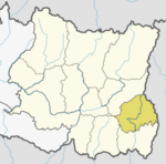
Ilam district is one of 14 districts of Koshi Province of eastern Nepal. It is a Hill district and covers 1,703 km2 (658 sq mi). The 2011 census counted 290,254 population. The municipality of Ilam is the district headquarters and is about 600 km (370 mi) from Kathmandu.

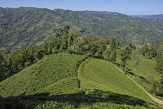
Ilam is one of four urban municipalities of Ilam District, which lies in the Mahabharata hilly range of Province No. 1, eastern Nepal. Ilam also acts as the headquarters of Ilam District. Being the largest producer region for Nepali tea, its tea farms comprise a major tourist attraction in Province No. 1. Ilam is also famous for its natural scenery and landscapes as well as its diverse agricultural economy which specializes in horticultural crop production.
Nagarain is a municipality in Dhanusha District in Province No. 2 of south-eastern Nepal. As of 2011 Nepal census, it has a population of 36,336 living in 6,478 individual households. It was formed by joining Fulgama, Devdiha, old Nagrain, Lagmagadha Guthi and Ghodghans village development committees. The total area of Nagarain municipality is 38.71 km2.
Dhuseni Siwalaya is a village development committee in Kabhrepalanchok District in Bagmati Province of central Nepal. At the time of the 1991 Nepal census it had a population of 2,049 and had 379 houses in it.
Chulachuli is a rural municipality (gaunpalika) out of six rural municipality located in Ilam District of Koshi Province of Nepal. There are a total of 10 municipalities in Ilam in which 4 are urban and 6 are rural.
Dhuseni is a town and Village Development Committee in Ilam District in the Province No. 1 of eastern Nepal. At the time of the 1991 Nepal census it had a population of 4,514.
Maimajhuwa is a town and Village Development Committee in Ilam District in the Province No. 1 of eastern Nepal. At the time of the 1991 Nepal census it had a population of 3,543 persons living in 578 individual households.
Phuyatappa is a town and Village Development Committee in Ilam District in the Province No. 1 of eastern Nepal. At the time of the 2011 Nepal census it had a population of 3,638 persons living in 840 individual households. The male population was 1667 while the female population was 1971 The village now lies in ward number 4 of Phakphokthum Rural Municipality of Ilam District after the political and structural changes of 2017 AD.
Sangrumba साङरुम्बा is a town and Village Development Committee in Ilam District in the Province No. 1 of eastern Nepal. At the time of the 1991 Nepal census it had a population of 4,607 persons living in 839 individual households. According to the VDC report of 2068 BS, the total population was 6,288 and the total number of households was 1,227, an average of 5.12 members per household.
Sulubung is a Village Development Committee in Ilam District in the Province No. 1 of eastern Nepal. At the time of the 1991 Nepal census it had a population of 3,470. Maipokhari, one of the major tourist and religious place of Nepal lies here. A company named Hesty Kiwi Private Limited has been established in this region which had helped to popularize this village with the plantation of kiwifruit. It is about 15 km from Ilam Bazaar. It is a hilly area having cold climate and mainly tea production is the income of most of the people here.
Dhuseni is a village development committee in Lamjung District in the Gandaki Zone of northern-central Nepal. At the time of the 1991 Nepal census it had a population of 1384 people living in 267 individual households.

Suryodaya Municipality is a municipality located in Koshi Pradesh of Nepal in Ilam district. Suryodaya is the Nepali translation for “Sunrise".
Deumai is a municipality in the eastern development region of Ilam District in the Mechi Zone of Nepal. The new municipality was formed by merging two existing villages Mangalbare and Dhuseni on 02 Dec 2014. The office of the municipality is that of the former Mangalbare village development committee.
Phakphokthum is a rural municipality, one of six located in Ilam District of Koshi Province of Nepal. A total of 10 municipalities are found in Ilam, of which 4 are urban and 6 are rural.
Mai is a municipality out of four municipalities of Ilam District of Province No. 1 of Nepal. It was formed in May 2017 with merging some VDC. Mahamai, Danabari and Chisapani VDCs were merged. The municipality is divided into ten wards which is surrounded by Deumai Municipality and Ilam Municipality from north, Suryodaya Municipality from north-east, Jhapa District from south-east and Mangsebung and Chulachuli Rural Municipality from west.
Maijogmai is a rural municipality (gaunpalika) out of six rural municipality located in Ilam District of Province No. 1 of Nepal. There are a total of 10 municipalities in Ilam in which 4 are urban and 6 are rural.
Rong is a rural municipality out of six rural municipalities located in Ilam District of Province No. 1 of Nepal. There are a total of 10 municipalities in Ilam in which 4 are urban and 6 are rural.
Mangsebung is a rural municipality (gaunpalika) out of six rural municipality located in Ilam District of Province No. 1 of Nepal. There are a total of 10 municipalities in Ilam in which 4 are urban and 6 are rural.
Sandakpur is a rural municipality (gaunpalika) out of six rural municipality located in Ilam District of Province No. 1 of Nepal. There are a total of 10 municipalities in Ilam in which 4 are urban and 6 are rural.
Chaurideurali is a Rural municipality located within the Kavrepalanchowk District of the Bagmati Province of Nepal. The municipality spans 98 square kilometres (38 sq mi) of area, with a total population of 20,829 according to a 2011 Nepal census.