Mangochi is a township in the Southern Region of Malawi. Located near the southern end of Lake Malawi, in colonial times it used to be called Fort Johnston. As of 2018, it has a population of 53,498.
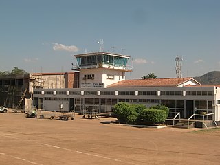
Chileka International Airport is an international airport in Malawi. It is located approximately 13 km, by road, northwest of Blantyre, the second largest city in the Republic of Malawi and the country's commercial and financial capital. Chileka is Malawi's second international airport, the other being Kamuzu International Airport, in Lilongwe, the nation's capital city.
Likoma District is the least populous district of Malawi, which consists of two separate exclaves of Malawi situated within Mozambican waters in Lake Malawi. It consists of two main islands, Likoma and Chizumulu. It is a district in the Northern Region of Malawi. The capital is Likoma. The district covers an area of 20 km², and has a population of 14,527.

Marianna Municipal Airport is an airport in Marianna, Jackson County, Florida, 5 miles (8.0 km) northeast of Downtown Marianna. The Federal Aviation Administration (FAA)'s National Plan of Integrated Airport Systems for 2009–2013 categorized it as a general aviation airport. It was formerly Graham Air Base.
FDH Bank, also FDH Bank Limited, is a commercial bank in Malawi. It is one of the commercial banks licensed by the Reserve Bank of Malawi, the central bank and national banking regulator.
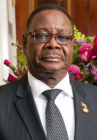
Arthur Peter Mutharika is a Malawian politician and lawyer who was President of Malawi from May 2014 to June 2020. Mutharika has worked in the field of international justice, specialising in international economic law, international law and comparative constitutional law. He informally served as an adviser to his older brother, President Bingu wa Mutharika, on issues of foreign and domestic policy from the onset of his election campaign until the President's death on 5 April 2012.
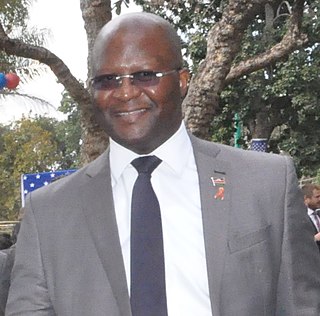
Atupele Muluzi is a Malawian politician, businessman and was a Member of Parliament for Machinga North East constituency from 2004 until May 27, 2019. He is also the President of the United Democratic Front and was a presidential candidate during the 2019 election. He was a running mate in the 2020 presidential elections, on a coalition ticket with incumbent President Peter Mutharika of the Democratic Progressive Party. Muluzi was Minister of Natural Resources, Energy and Mining from 2014 to 2015 and the only opposition member to serve in the Mutharika administration. Subsequently, he served as Minister of Home Affairs and Internal Security in 2015, and then Minister of Lands, Housing and Urban Development in 2015. He is the son of the former president Bakili Muluzi.
Lucious Grandson Kanyumba is a politician who has served in ministerial positions in Malawi. He was appointed Minister of Youth Development and Sports in the cabinet of Malawi in June 2009. He later served as Minister of Education.

Nancy Gladys Tembo is a Malawian politician and serves as Minister of Foreign Affairs in the Malawi Government since 2022. She is also a Member of Parliament (MP) representing Lilongwe City South West constituency in the National Assembly of the Republic of Malawi.

Malawi Airlines is the flag carrier airline of Malawi, based in Lilongwe and with its hub at Kamuzu International Airport. It was established in 2012 after the liquidation of Air Malawi, the former national airline. Ethiopian Airlines operates it under a management contract and owns 49% of the airline after it emerged as the winner following competitive bidding.

The history of rail transport in Malawi began shortly after the turn of the twentieth century.
Brighton Vitta Malasa is a Malawian who was Bishop of the Anglican Diocese of Upper Shire, one of the four Malawian Anglican dioceses within the Church of the Province of Central Africa. He was Bishop of Upper Shire from 2008 until 2022 when he was excommunicated from the Church by Archbishop Albert Chama of the Church of the Province of Central Africa.
The Lirangwe–Chingale–Machinga Road is a road in the Southern Region of Malawi, connecting the towns of Lirangwe in Blantyre District to the towns of Chingale in Zomba District and the town of Machinga in Machinga District.
MV Vipya was a motor vessel used as a passenger-cargo ship that sailed on Lake Malawi in Nyasaland from 1944 to 1946. The ferry had a tonnage of 470 tons, was 140 feet (43 m) in length, 27 feet (8.2 m) in breadth, and had a twin crew. Equipped with a motor engine, it could travel up to a speed of 12 knots. It was built to carry 315 passengers and 100 tons of cargo. On July 30, 1946, the ship set sail with 194 passengers on board. It was caught up in a storm near Chilumba in Karonga where it capsized and sank. The disaster resulted in 145 passengers and crew on board drowning. No remains of the bodies have been recovered. The sternwheel ferry disaster is the worst shipwreck in Malawi's history.
Clement Terence Chiwaya was a Malawian politician who served as an MP for Mangochi Central from 2004 to 2019. He was also Minister of Social Development and Persons with Disabilities from 2004 through 2005.
The Unbroken Spirit, is a 2019 Malawian romantic drama film directed by Imran Kingsly Shaban and produced by Imran Pitersen Kaisi. The film stars Ken Kananji and Bertha Nkhoma in lead roles whereas Abdullah and Kamlanje Fantasia Mkwamba made supportive roles. The film was shot in the Malawi Mangochi District at Che Moto Village.
Dan Lufani, best known as Dan Lu, and sometimes written as Dan Lufan, is a Malawian Afro-pop singer and songwriter. In 2011, he was awarded as best Afro pop artist of the year in Malawi Music Awards. In 2016, he was nominated in best R&B/Afro-pop Act along with other artists such as Theo Thomson and Kell Kay.
Shukuran Mwachumu better known by his stage name Janta, is a Malawian Afro Pop artist. In 2015, his song titled Wangongole won a Nyasa Music Award in Best Song of the Year category. In 2019, his music video won Best video of the year in UMP Awards.
Roseby Gadama became the Malawian member of parliament for Zomda Thondwe in 2019. She is the chair of the Malawi Parliamentary Women's Caucus and she sits on the Public Accounts Committee.
Victoria Kingstone is a Malawian MP for central Mangochi in southern Malawi. In 2021 she also became a member of the Pan-African Parliament.