Mzuzu Airport

Last updated
Mzuzu Airport
Summary
Airport type Public
Operator Government
Serves Mzuzu, Malawi
Elevation  AMSL 4,115 ft / 1,254 m
Coordinates 11°26′41″S034°00′42″E / 11.44472°S 34.01167°E / -11.44472; 34.01167
Map
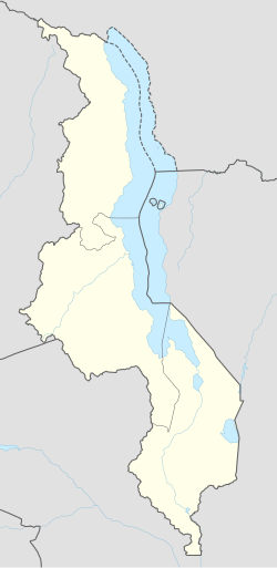
Malawi adm location map.svg
Airplane silhouette.svg
ZZU
Location of airport in Malawi
Runways
Direction Length Surface
m ft
17/35 1,308 4,291 Bitumen
Source: DAFIF [1] [2]

Mzuzu Airport( IATA : ZZU, ICAO : FWUU) is an airport serving Mzuzu, [1] the capital city of the Northern Region of the Republic of Malawi.
An IATA airport code, also known as an IATA location identifier, IATA station code or simply a location identifier, is a three-letter code designating many airports around the world, defined by the International Air Transport Association (IATA). The characters prominently displayed on baggage tags attached at airport check-in desks are an example of a way these codes are used.

ICAO airport code four-letter code designating many airports around the world

The ICAOairport code or location indicator is a four-letter code designating aerodromes around the world. These codes, as defined by the International Civil Aviation Organization and published in ICAO Document 7910: Location Indicators, are used by air traffic control and airline operations such as flight planning.

Airport location where aircraft take off and land

An airport is an aerodrome with extended facilities, mostly for commercial air transport. Airports often have facilities to store and maintain aircraft, and a control tower. An airport consists of a landing area, which comprises an aerially accessible open space including at least one operationally active surface such as a runway for a plane to take off or a helipad, and often includes adjacent utility buildings such as control towers, hangars and terminals. Larger airports may have airport aprons, taxiway bridges, air traffic control centres, passenger facilities such as restaurants and lounges, and emergency services. In some countries, the US in particular, they also typically have one or more fixed-base operators, serving general aviation.

Contents

Facilities

The airport resides at an elevation of 4,115 feet (1,254 m) above mean sea level. It has one runway designated 17/35 with a bitumen surface measuring 1,308 by 19 metres (4,291 ft × 62 ft). [1]

Elevation Height of a geographic location above a fixed reference point

The elevation of a geographic location is its height above or below a fixed reference point, most commonly a reference geoid, a mathematical model of the Earth's sea level as an equipotential gravitational surface . The term elevation is mainly used when referring to points on the Earth's surface, while altitude or geopotential height is used for points above the surface, such as an aircraft in flight or a spacecraft in orbit, and depth is used for points below the surface.

Runway Area of surface used by aircraft to takeoff from and land on

According to the International Civil Aviation Organization (ICAO), a runway is a "defined rectangular area on a land aerodrome prepared for the landing and takeoff of aircraft". Runways may be a man-made surface or a natural surface.

Airlines and destinations

Related Research Articles

Kimberley Airport airport

Kimberley Airport is an airport serving Kimberley, the capital city of the province of Northern Cape in South Africa.

Chileka International Airport airport serving Blantyre, Malawi

Chileka International Airport is an airport located 16 km from Blantyre, the second largest city in the Republic of Malawi and the commercial Capital of Malawi's Southern Region.

Montpellier–Méditerranée Airport airport

Montpellier–Méditerranée Airport or Aéroport de Montpellier–Méditerranée, also known as Fréjorgues Airport, is an airport in southern France. It is located 7 km east-southeast of Montpellier in Mauguio, in the Hérault department of the Languedoc-Roussillon region in France. The airport opened in 1946, 8 years after the first flight to the area.

Cuneo International Airport airport

Cuneo International Airport also named Cuneo Levaldigi Airport or Turin Cuneo Airport by some low-cost airlines, is an airport serving Cuneo and Turin, Piedmont, Italy. It is the second airport of Piedmont, after Turin Airport.

Castres–Mazamet Airport french airport

Castres – Mazamet Airport is an airport serving Castres and Mazamet and the east of Midi-Pyrénées. The airport is located 7 km (4 mi) southeast of Castres and northwest of Mazamet, near the commune of Labruguière, in the Tarn department.

Asosa Airport airport in Ethiopia

Asosa Airport is an airport serving Asosa, the capital of the western Benishangul-Gumuz Region in Ethiopia. The name of the city and airport may also be transliterated as Assosa. The airport is located 5.5 km southeast of the city.

Gambela Airport airport in Ethiopia

Gambela Airport is an airport serving Gambela, the capital city of the Gambela Region in Ethiopia. The name of the city and airport may also be transliterated as Gambella. The airport is located 17 km south of the city. It also serves the Gambela National Park.

Aba Segud Airport airport in Ethiopia

Aba Segud Airport, also known as Jimma Airport, is an airport serving Jimma, a city in the Oromia Region of Ethiopia. The airport is located 2.5 km southwest of the city.

Lalibela Airport airport in Ethiopia

Lalibela Airport is an airport serving Lalibela, a city in the Amhara Region of Ethiopia. The name of the city and airport may also be transliterated as Lalibella. The airport is located 23 km southwest of the city.

Lilongwe International Airport airport serving Lilongwe, Malawi

Kamuzu International Airport is an international airport serving Lilongwe, the capital city of Malawi. It is also known as Lilongwe International Airport.

Essaouira-Mogador Airport airport in Morocco

Essaouira-Mogador Airport is an international airport serving Essaouira, a city in the Marrakesh-Safi region in Morocco.

Borkum Airfield airport in Germany

Borkum Airfield is an airfield serving Borkum, an island and a municipality in the Leer district in the German state of Lower Saxony.

Emden Airport airport in Lower Saxony, Germany

Emden Airport is an airfield serving Emden, a city in the East Frisia region of the German state of Lower Saxony.

Nakhchivan International Airport Airport in Azerbaijan

Nakhchivan International Airport is a civilian airport and Azeri military airbase located in Nakhchivan, the capital of the Nakhchivan Autonomous Republic, a landlocked exclave of Azerbaijan. The airport was built in the 1970s.

Steung Treng Airport airport in Cambodia

Stung Treng Airport is an airport serving Stung Treng, the capital of Stung Treng Province in Cambodia. The Airport was closed in 1994, but there’s a helipad that is still in use today.

Kalimarau Airport Indonesian airport

Raja Alam International Airport, also known as Kalimarau Airport, is an Airport serving Tanjung Redeb in the Berau Regency, North Kalimantan province, Indonesia. Recently, a new terminal building with a capacity of more than five hundred passengers and two aerobridge was inaugurated on October 2012.

Karonga Airport airport in Malawi

Karonga Airport is an airport serving Karonga, a town in the Northern Region of the Republic of Malawi and the best Airport in the Northern part of Malawi.

Kasungu Airport airport in Malawi

Kasungu Airport is an airport serving Kasungu, a town in the Central Region of the Republic of Malawi.

Fasa Airport airport in Iran

Fasa Airport is an airport serving Fasa, a city in the Fars Province in Iran.

Sancti Spíritus Airport airport in Sancti Spíritus, Cuba

Sancti Spíritus Airport is an airport serving Sancti Spíritus, the capital city of the Sancti Spíritus Province in Cuba.

References

  1. 1 2 3 Airport information for FWUU from DAFIF (effective October 2006)
  2. Airport information for ZZU at Great Circle Mapper. Source: DAFIF (effective October 2006).
National Oceanic and Atmospheric Administration An American scientific agency within the US Department of Commerce that focuses on the oceans and the atmosphere

The National Oceanic and Atmospheric Administration is an American scientific agency within the United States Department of Commerce that focuses on the conditions of the oceans, major waterways, and the atmosphere.

National Weather Service United States weather agency

The National Weather Service (NWS) is an agency of the United States federal government that is tasked with providing weather forecasts, warnings of hazardous weather, and other weather-related products to organizations and the public for the purposes of protection, safety, and general information. It is a part of the National Oceanic and Atmospheric Administration (NOAA) branch of the Department of Commerce, and is headquartered in Silver Spring, Maryland, within the Washington metropolitan area. The agency was known as the United States Weather Bureau from 1890 until it adopted its current name in 1970.

The Aviation Safety Network (ASN) is a website that keeps track of aviation accidents, incidents, and hijackings. Their database contains details of over 10,700 reports. The ASN includes an aviation database with aviation investigations, news, photos, and statistics.