Mahakali was one of the fourteen zones located in the Far-Western Development Region of Nepal, covering an area of 6,205 km2 in the westernmost part of the country. It stretches along Nepal's far western border with India, marked by the Kali River or Mahakali River.

Baitadi District, historical name “Bairath” (बैराथ), a part of Sudurpashchim Province, is one of the 77 districts of Nepal. It is a Hill district. Baitadi, with Dasharathchand as its headquarters, covers an area of 1,519 km2 (586 sq mi) and has a population of 250,898 according to the census (2011). The Baitadi district entails 56 village development councils (VDCs) and two municipality in the past. Now, by federal policy there are 10 local units; 4 Municipalities and 6 Rural Municipalities. Baitadi falls into the farthest western regional district of Nepal touching Jhulaghat, India, Nepal's neighboring country, to its border.
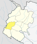
Dadeldhura, a part of Sudurpashchim Province, is one of the seventy-seven districts of Nepal. The district, with Dadeldhura as its district headquarters, covers an area of 1,538 km2 (594 sq mi) and had a population of 126,162 in 2001 and 142,094 in 2011.

Darchula District is one of the nine districts of Sudurpashchim Province. The area, with Khalanga as its capital, covers an area of 2,322 km2 (897 sq mi) and has a population (2011) of 133,274. Darchula lies in the west-north corner of the country.
Chipur is a village development committee in Dadeldhura District in the Mahakali Zone of western Nepal. At the time of the 1991 Nepal census, it had a population of 2589 people living in 483 individual households.
Dewal Dibyapur is a village development committee in Dadeldhura District in the Mahakali Zone of western Nepal. At the time of the 1991 Nepal census it had a population of 5258 people living in 939 individual households.
Dhatal is a village development committee in Dadeldhura District in the Mahakali Zone of western Nepal. At the time of the 1991 Nepal census it had a population of 3571 people living in 612 individual households.
Ganeshpur is a village development committee in Dadeldhura District in the Mahakali Zone of western Nepal. At the time of the 1991 Nepal census it had a population of 3412 people living in 649 individual households.
Gankhet is a village development committee in Dadeldhura District in the Mahakali Zone of western Nepal. At the time of the 1991 Nepal census it had a population of 3680 people living in 600 individual households.
Jogbuda is a village development committee in Dadeldhura District in the Mahakali Zone of western Nepal. At the time of the 1991 Nepal census it had a population of 13,521 people living in 2191 individual households.
Kailapalmandau is a village development committee in Dadeldhura District in the Mahakali Zone of western Nepal. At the time of the 1991 Nepal census it had a population of 3344 people living in 694 individual households.
Koteli is a village development committee in Dadeldhura District in the Mahakali Zone of western Nepal. At the time of the 1991 Nepal census it had a population of 3301 people living in 605 individual households.
Mashtamandau is a village development committee in Dadeldhura District in the Mahakali Zone of western Nepal. At the time of the 1991 Nepal census it had a population of 2844 people living in 525 individual households.
Nawadurga is a village development committee in Dadeldhura District in the Mahakali Zone of western Nepal. At the time of the 1991 Nepal census it had a population of 2639 people living in 484 individual households.

Rupal is a village development committee in Dadeldhura District in the Mahakali Zone of western Nepal. At the time of the 1991 Nepal census it had a population of 4531 people living in 779 individual households.
Sahasralinga is a village development committee in Dadeldhura District in the Mahakali Zone of western Nepal. At the time of the 1991 Nepal census it had a population of 3412 people living in 657 individual households.
Samaiji is a village development committee in Dadeldhura District in the Mahakali Zone of western Nepal. It is named after the name of god Samaiji. It is divided into 9 wards. Ward no: 1 Pali Ward no: 2 Bakayal Ward no: 3 Bajkot Ward no: 4 Khateda Ward no: 5 Mudrad Ward no: 6 Silangi Ward no: 7 Baida Ward no: 8 Mahargaun Ward no: 9 koteli The headquarters is located at a small town named Puilek. It is around 14 km from the district headquarters. The major destination of this V.D.C. includes the natural beauties and some temples. Some famous temples are Kola Samaiji, Pali Samaiji, Shikhar Samaiji etc. There are 2 higher secondary schools in the V.D.C. And a graveled road has made it possible to touch the district headquarters. The facilities like water, sanitation, telephone and electricity are accessible to the locals but they are still lacking proper education, hospital and even transportation at the need. One has to walk 14 km to reach the nearest hospital, bank and for all other basic things. At the time of the 1991 Nepal census it had a population of 2184 people living in 382 individual households.
Sirsha is a village development committee in Dadeldhura District in the Mahakali Zone of western Nepal. The 1991 Nepal census noted a population of 7878 people living in 1269 individual households.

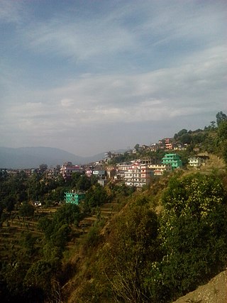
Amargadhi is a municipality and the district headquarter of Dadeldhura District in Sudurpashchim Province of western Nepal. It was named after Gorkha General Amar Singh Thapa, who fought in the Gurkha War between 1814 and 1816 At the time of the 2011 Nepal census it had a population of 21,245 people living in 4,778 individual households.