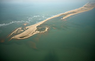
Dhanushkodi is an abandoned town at the south-eastern tip of Pamban Island of the state of Tamil Nadu in India. It is south-east of Pamban and is about 24 kilometres (15 mi) west of Talaimannar in Sri Lanka. The town was destroyed during the 1964 Rameswaram cyclone and remains uninhabited in the aftermath. Although devoid of inhabitants, Dhanushkodi remains a tourist attraction due to its historical and mythological relevance.
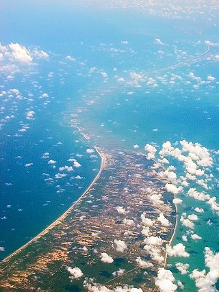
Adam's Bridge, also known as Rama's Bridge or Rama Setu, is a chain of natural limestone shoals between Pamban Island, also known as Rameswaram Island, off the southeastern coast of Tamil Nadu, India, and Mannar Island, off the northwestern coast of Sri Lanka. Geological evidence suggests that the bridge was formerly a land connection between India and Sri Lanka.
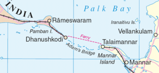
Palk Strait is a strait between the Indian state of Tamil Nadu and Northern Province of Sri Lanka. It connects the Palk Bay in the Bay of Bengal in the north with the Gulf of Mannar in the Laccadive sea in the south. It stretches for about 137 km (85 mi) and is 64 to 137 km wide. It is named after Robert Palk, who was a governor of Madras (1755–1763) during the Company Raj period.

Rameswaram is a municipality in the Ramanathapuram district of the Indian state of Tamil Nadu. It is on Pamban Island separated from mainland India by the Pamban channel and is about 40 kilometres (25 mi) from Mannar Island, Sri Lanka. It is in the Gulf of Mannar, at the tip of the Indian peninsula. Pamban Island, also known as Rameswaram Island, is connected to mainland India by the Pamban Bridge. Rameswaram is the terminus of the railway line from Chennai and Madurai. Together with Varanasi, it is considered to be one of the holiest places in India to Hindus and is part of the Char Dham pilgrimage.
Elephant Pass is located at the gateway of the Jaffna Peninsula in Northern Province, Sri Lanka. It lies about 340 km north of the capital. It has an important military base and used to be the island's largest salt field. It was regularly the site of battles during the Sri Lankan Civil War.

Mannar Island, formerly spelt Manar Island, which lies off the north-western coast of Sri Lanka, is part of Mannar District, Sri Lanka. It is linked to the main island of Sri Lanka by a causeway and the Mannar Bridge, which carries the A14 highway, and a railway bridge. It has an area of about 130 square kilometres (50 sq mi), mainly covered with vegetation and sand.
A fixed link or fixed crossing is a permanent, unbroken road or rail connection across water that uses some combination of bridges, tunnels, and causeways and does not involve intermittent connections such as drawbridges or ferries. A bridge–tunnel combination is commonly used for major fixed links.
Mannar may refer to the following places:

The Sri Lanka Railway Department is Sri Lanka's railway owner and primary operator. As part of the Sri Lankan government, it is overseen by the Ministry of Transport. Founded in 1858 as the Ceylon Government Railway, it operates the nation's railways and links Colombo with other population centres and tourist destinations.

Talaimannar is a settlement in Sri Lanka located on the northwestern coast of Mannar Island.

The Northern Province is one of the nine provinces of Sri Lanka. The province has an area of 8,884 km2, making it the 3rd largest province by area, and a population of 1,061,315, making it the least populated province. Jaffna is the capital city of the province.

Mannar District is one of the 25 districts of Sri Lanka, the second level administrative division of the country. The district is administered by a District Secretariat headed by a District Secretary appointed by the central government of Sri Lanka. The capital of the district is Mannar, which is located on Mannar Island.
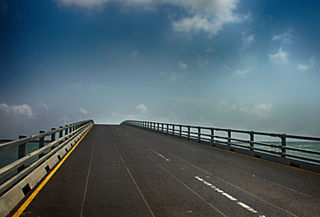
Sangupiddy Bridge is a road bridge across Jaffna Lagoon in northern Sri Lanka. It connects Sangupiddy in Kilinochchi District to Karaitivu in Jaffna District. It is one of only two road bridges connecting the densely populated Jaffna Peninsula with the mainland.

The northern line is a railway line in Sri Lanka. Branching off the Main Line at Polgahawela Junction the line heads north through North Western, North Central and Northern provinces before terminating at the northern port of Kankesanthurai. The line is 339 kilometres (211 mi) long and has 55 stations between Polgahawela Junction and Vavuniya. It is the longest railway line in Sri Lanka. The line opened in 1894. Major cities served by the line include Kurunegala, Anuradhapura, Vavuniya,Kilinochchi and Jaffna. The popular Yal Devi service operates on the line. The line was severely affected by the civil war and no services operated north of Vavuniya after 1990. Reconstruction of this section of the line commenced following the end of the civil war in 2009 and was fully completed in early 2015.
The Mannar line is a railway line in Sri Lanka. Branching off the northern line at Medawachchiya Junction, the line heads north-west through North Central and Northern provinces before terminating at the town of Talaimannar. The line is 106 kilometres (66 mi) long and has 11 stations. The line opened in 1914.

Kallady Bridge is a road bridge in eastern Sri Lanka. It crosses the Batticaloa Lagoon at Batticaloa. The bridge is part of the A4 Colombo-Batticaloa highway.
Manmunai Bridge is a road bridge in Batticaloa District, Sri Lanka. It crosses the Batticaloa Lagoon and connects Western and Eastern shore of the Batticaloa lagoon.
Mannar Fort is located on Mannar Island, Sri Lanka. It was built by Portuguese in 1560 and christened São Jorge. The fort fell to the Dutch in 1658, and they rebuilt the fort in 1696. In 1795 the British occupied the fort following the surrender by the Dutch.
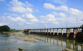
Iranamadu Tank is an irrigation tank in northern Sri Lanka, approximately 3 mi (5 km) south east of Kilinochchi.


