Conesville is a town in Schoharie County, New York, United States. The population was 726 at the 2000 census. The town is named after Jonathan Cone, an early resident.

Gilboa is a town in Schoharie County, New York, United States. The population was 1,215 at the 2000 census.

The Mohawk River is a 149-mile-long (240 km) river in the U.S. state of New York. It is the largest tributary of the Hudson River. The Mohawk flows into the Hudson in Cohoes, New York, a few miles north of the city of Albany. The river is named for the Mohawk Nation of the Iroquois Confederacy. It is a major waterway in north-central New York. The largest tributary, the Schoharie Creek, accounts for over one quarter (26.83%) of the Mohawk River's watershed. Another main tributary is the West Canada Creek, which makes up for 16.33% of the Mohawk's watershed.

The West Branch Delaware River is one of two branches that form the Delaware River. It is approximately 90 mi (144 km) long, and flows through the U.S. states of New York and Pennsylvania. It winds through a mountainous area of New York in the western Catskill Mountains for most of its course, before joining the East Branch along the northeast border of Pennsylvania with New York. Midway or so it is empounded by the Cannonsville Dam to form the Cannonsville Reservoir, both part of the New York City water supply system for delivering drinking water to the City.

Schoharie Creek is a river in New York that flows north 93 miles (150 km) from the foot of Indian Head Mountain in the Catskills through the Schoharie Valley to the Mohawk River. It is twice impounded north of Prattsville to create New York City's Schoharie Reservoir and the Blenheim-Gilboa Power Project.

Esopus Creek is a 65.4-mile-long (105.3 km) tributary of the Hudson River that drains the east-central Catskill Mountains in the U.S. state of New York. From its source at Winnisook Lake on the slopes of Slide Mountain, the Catskills' highest peak, it flows across Ulster County to the Hudson at Saugerties. Many tributaries extend its watershed into neighboring Greene County and a small portion of Delaware County. Midway along its length, it is impounded at Olive Bridge to create Ashokan Reservoir, the first of several built in the Catskills as part of New York City's water supply system. Its own flow is supplemented 13 miles (21 km) above the reservoir by the Shandaken Tunnel, which carries water from the city's Schoharie Reservoir into the creek.

New York State Route 990V (NY 990V) is an east–west reference route in Schoharie County, New York, in the United States. It extends for 6.15 miles (9.90 km) from an intersection with NY 30 in the town of Gilboa to a junction with County Route 18 (CR 18) in the town of Conesville, where the road continues east as CR 3. Reference routes in New York are typically unsigned; however, NY 990V is fully signed with touring route markers. The road is a remnant of New York State Route 342, a route assigned as part of the 1930 renumbering of state highways in New York. The NY 342 designation was removed in the late 1940s; however, its former routing from Gilboa to Conesville remained a state highway and became NY 990V when the modern reference route system in New York was created.

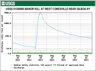
The Schoharie Reservoir is a reservoir in the Catskill Mountains of New York State that was created to be one of 19 reservoirs that supplies New York City with water. It was created by impounding Schoharie Creek. Portions of it lie in the towns of Conesville and Gilboa in Schoharie County, Roxbury in Delaware County, and Prattsville in Greene County.

Stony Clove Creek is a 10.3-mile-long (16.6 km) creek in the Catskill Mountains in New York. It is a tributary of Esopus Creek, which in turn is a tributary of the Hudson River. It joins the Esopus in the village of Phoenicia, and has two smaller tributaries up north of Phoenicia.

Fox Creek is a 24.8-mile-long (39.9 km) tributary of Schoharie Creek in Schoharie and Albany counties in the U.S. state of New York. It rises in the southeastern part of the town of Berne, west of the Helderberg Mountains, and flows west, passing through the hamlets of East Berne, Bensons Corner, Berne, and West Berne, continuing through the town of Wright, where it passes the hamlets of Gallupville and Shutter Corners before entering the town of Schoharie, where it flows into Schoharie Creek near the hamlet of Vroman Corners. Fox Creek is part of the Hudson River watershed, Via Schoharie Creek and the Mohawk River.

Spring Brook is a tributary of the Lackawanna River in Lackawanna County and Luzerne County, in Pennsylvania, in the United States. It is approximately 17 miles (27 km) long and flows through Covington Township, Spring Brook Township, and Moosic in Lackawanna County and Pittston Township in Luzerne County. The watershed of the stream has an area of 57.2 square miles (148 km2). It is designated as a High-Quality Coldwater Fishery and a Migratory Fishery above Interstate 476 and as a Coldwater Fishery and a Migratory Fishery below it. A section is also designated as Class A Wild Trout Waters. The stream's tributaries include Panther Creek, Plank Bridge Creek, Rattlesnake Creek, Green Run, Monument Creek, and Covey Swamp Creek. It has a relatively high level of water quality and is very slightly acidic, with a pH of 6.4 to 6.9.
Sauquoit Creek is a 17.0-mile-long (27.4 km) river in New York, United States. It lies within the southern part of Oneida County. The creek flows eastward, then turns sharply and flows generally northward through the Sauquoit Valley to the Mohawk River, entering the river on the east side of Whitesboro. It is therefore part of the Hudson River watershed.
Fulmer Creek is an 11.5-mile-long (18.5 km) river that flows into the Mohawk River in Mohawk, New York. The creek derives its name from the "Fulmer" family, who bought land through the Burnetsfield patent of 1725, in which lands on the present village site were granted out.
Cobleskill Creek is a river in Otsego and Schoharie counties in the state of New York. It starts at Pine Mountain west of West Richmondville and flows east-northeast before converging with Schoharie Creek in Central Bridge. The creek flows through the villages of Richmondville and Cobleskill.
East Kill, a 16-mile-long (26 km) tributary of Schoharie Creek, flows across the town of Jewett, New York, United States, from its source on Stoppel Point. Ultimately its waters reach the Hudson River via the Mohawk. Since it drains into the Schoharie upstream of Schoharie Reservoir, it is part of the New York City water supply system. East Kill drains the southern slopes of the Blackhead Mountains, which include Thomas Cole Mountain, Black Dome, and Blackhead Mountain, the fourth-, third-, and fifth-highest peaks in the Catskills, respectively.
Little Schoharie Creek is a river in Schoharie and Albany counties in the state of New York. It converges with the Schoharie Creek in Middleburgh.
The West Kill, an 11-mile-long (18 km) tributary of Schoharie Creek, flows through the town of Lexington, New York, United States, from its source on Hunter Mountain, the second-highest peak of the Catskill Mountains. Ultimately its waters reach the Hudson River via the Mohawk. Since it drains into the Schoharie upstream of Schoharie Reservoir, it is part of the New York City water supply system. It lends its name to both a mountain to its south and a small town midway along its length.

Batavia Kill is a 21-mile-long (34 km) tributary of Schoharie Creek, that flows across the towns of Windham, Ashland and Prattsville in the U.S. state of New York. Its waters reach the Hudson River via Schoharie Creek and the Mohawk River. Since it drains into the Schoharie upstream of Schoharie Reservoir, it is part of the New York City water supply system. From the source to Maplecrest, Batavia Kill drains the northern slopes of the Blackhead Mountains, which include Thomas Cole Mountain, Black Dome, and Blackhead Mountain, the fourth-, third-, and fifth-highest peaks in the Catskills, respectively.
Mine Kill is a river in Schoharie County in the state of New York. It flows into the Schoharie Creek by Gilboa, New York. Mine Kill Falls is located on the creek where it passes under State Route 30.
Platter Kill is a river in Schoharie County in the state of New York. It flows into the Schoharie Creek. The Platter Kill's 11-square-mile (28 km2) watershed accounts for about 1.2 percent of the Schoharie basin.