
Gary is a city in Lake County, Indiana, United States. The city has been historically dominated by major industrial activity and is home to U.S. Steel's Gary Works, the largest steel mill complex in North America. Gary is located along the southern shore of Lake Michigan about 25 miles (40 km) southeast of downtown Chicago, Illinois. The city is adjacent to the Indiana Dunes National Park, and is within the Chicago metropolitan area.

St. Joseph County, commonly called St. Joe County by residents, is a county located in the U.S. state of Indiana. As of the 2020 census, the population was 272,912, making it the fifth-most populous county in Indiana. Formed in 1830, it was named for the St. Joseph River which flows through it to Lake Michigan. The county seat is South Bend. St. Joseph County is part of the South Bend–Mishawaka, IN–MI "Michiana", Metropolitan Statistical Area.

Elkhart County is a county located in the U.S. state of Indiana. As of 2020, the county's population was 207,047. The county seat is Goshen. Elkhart County is part of the Elkhart-Goshen Metropolitan Statistical Area, which in turn is part of the South Bend-Elkhart-Mishawaka Combined Statistical Area. It is also considered part of the broader region of Northern Indiana known as Michiana, and is 20 miles (32 km) east of South Bend, Indiana, 110 miles (180 km) east of Chicago, Illinois, and 150 miles (240 km) north of Indianapolis, Indiana. The area is referred to by locals as the recreation vehicle (RV) capital of the world and is known for its sizable Amish and Old Order Mennonite population.

Elkhart is a city in Elkhart County, Indiana, United States. The city is located 15 miles (24 km) east of South Bend, Indiana, 110 miles (180 km) east of Chicago, Illinois, and 150 miles (240 km) north of Indianapolis, Indiana. Elkhart has the larger population of the two principal cities of the Elkhart-Goshen Metropolitan Statistical Area, which in turn is part of the South Bend-Elkhart-Mishawaka Combined Statistical Area, in a region commonly known as Michiana. The population was 53,923 at the 2020 census. Despite the shared name and being the most populous city in the county, it is not the county seat of Elkhart County; that position is held by the city of Goshen, located about 10 miles (16 km) southeast of Elkhart.
Kokomo is a city in Indiana and the county seat of Howard County, Indiana, United States. Its population increased from 45,468 at the 2010 census to 59,604 in the 2020 census. It is the principal city of the Kokomo, Indiana Metropolitan Statistical Area, which includes all of Howard County, the Kokomo-Peru CSA, which includes Howard and Miami counties, as well as the North Central Indiana region consisting of six counties anchored by the city of Kokomo.

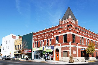
La Porte is a city in LaPorte County, Indiana, United States, of which it is the county seat. Its population was estimated to be 21,341 in 2022. It is one of the two principal cities of the Michigan City-La Porte, Indiana metropolitan statistical area, which is included in the Chicago–Naperville–Michigan City, Illinois–Indiana–Wisconsin combined statistical area.

South Bend is a city in and the county seat of St. Joseph County, Indiana, United States, on the St. Joseph River near its southernmost bend, from which it derives its name. At the 2020 census, the city had a total of 103,453 residents and is the fourth-largest city in Indiana. The metropolitan area had a population of 324,501 in 2020, while its combined statistical area had 812,199. The city is located just south of Indiana's border with Michigan.
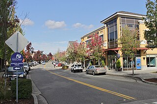
Mill Creek is a city in Snohomish County, Washington, United States. It is located between the cities of Everett and Lynnwood, approximately 20 miles (32 km) northeast of Seattle. The city has a population of 20,926 as of the 2020 census. The city lies along State Route 527 and North Creek, a tributary of the Sammamish River, on the east side of Interstate 5.

Missouri City is a city in the U.S. state of Texas, within the Houston–The Woodlands–Sugar Land metropolitan area. The city is mostly in Fort Bend County, with a small portion in Harris County. As of the 2020 census, the city had a population of 74,259, up from 67,358 in 2010. The population was estimated at 75,457 in 2019.

Kingwood is a 14,000-acre (57 km2) master-planned community located in northeast Houston, Texas, United States. The majority of the community is located in Harris County with a small portion in Montgomery County. Known as the "Livable Forest," it is the largest master-planned community in Harris County and second-largest within the 10-county Houston-The Woodlands-Sugar Land metropolitan area. It was classified as a "census-designated place" during the 1990 census, when the population recorded was 37,397. It is on the east fork of the San Jacinto River.

The St. Joseph Valley Parkway is a freeway in the U.S. states of Indiana and Michigan, serving as a bypass route around Elkhart, Mishawaka, and South Bend in Indiana and Niles in Michigan. The freeway runs to the south and west of Elkhart and South Bend and Niles and consists of segments of U.S. Route 31 (US 31) and US 20; those two highway designations run concurrently at the southwestern rim of the South Bend metropolitan area. It continues north to run along the St. Joseph River valley.
Airdrie is a city in Alberta, Canada, within the Calgary Region. It is located north of Calgary within the Calgary–Edmonton Corridor at the intersection of Queen Elizabeth II Highway and Highway 567.

The South Shore Line is an electrically powered interurban commuter rail line operated by the Northern Indiana Commuter Transportation District (NICTD) between Millennium Station in downtown Chicago and the South Bend International Airport in South Bend, Indiana, United States. The name refers to both the physical line and the service operated over that route. The line was built in 1901–1908 by predecessors of the Chicago South Shore and South Bend Railroad, which continues to operate freight service. Passenger operation was assumed by the NICTD in 1989. The South Shore Line is one of the last surviving interurban trains in the United States. In 2022, the system had a ridership of 1,406,400, or about 5,000 per weekday as of the second quarter of 2023.

Hegewisch is one of the 77 community areas of Chicago, Illinois, located on the city's far south side. It is bordered by the neighborhoods of Riverdale and South Deering to the west, the East Side to the north, the village of Burnham to the south and the city of Hammond, Indiana to the east. The community area is named for Adolph Hegewisch, the president of U.S. Rolling Stock Company who hoped to establish "an ideal workingman's community" when he laid out the town along a rail line in 1883, six years before Chicago annexed the town.

South Bend International Airport is a commercial and freight airport located three miles northwest of downtown South Bend, in St. Joseph County, Indiana, United States. It is the state's second busiest airport in terms of passenger traffic after Indianapolis International Airport.

Clay Township is one of 13 townships in St. Joseph County, in the U.S. state of Indiana. As of the 2000 census, its population was 34,235.

Miller Beach is a neighborhood of Gary, Indiana on the southernmost shore of Lake Michigan. First settled in 1851, Miller Beach was originally an independent town. However, the "Town of Miller" was eventually annexed by the then flourishing city of Gary in 1918. Located in the northeastern corner of Lake County, Indiana, the former town is now known as "The Miller Beach Community." Miller Beach borders Lake Michigan to the north, Porter County to the east, and is largely surrounded by protected lands, including Indiana Dunes National Park. Miller Beach is also the closest beach/resort community to Chicago, and has been a popular vacation spot since the early 20th century. As of the 2000 US census, it had a population of 9,900.
Erskine Village is a shopping mall in South Bend, Indiana, United States. It opened in 2004 on the site of the former Scottsdale Mall, an enclosed shopping mall which featured L. S. Ayres, Ayr-Way, and Montgomery Ward. After experiencing a decline in tenancy throughout the late 1980s and into the 1990s, the property was torn down in 2003 and redeveloped the following year as a strip mall. Tenants of Erskine Village include Target, Ross Dress for Less, TJ Maxx, and Kohl's.

Tremont was a flag stop on the South Shore Line located at Tremont Road in Porter County, Indiana. The station was built by the Chicago, Lake Shore and South Bend Railway and opened circa 1908, serving its namesake town and later the Indiana Dunes.


