Related Research Articles
The Borough of Swindon is a local government authority in South West England, centred on the town of Swindon and forming part of the ceremonial county of Wiltshire.

Caversham is a suburb of Reading, England. Originally a village founded in the Middle Ages, it lies on the north bank of the River Thames, opposite the rest of Reading. Caversham Bridge, Reading Bridge, Christchurch Bridge, and Caversham Lock provide crossing points, with Sonning Bridge also available a few miles east of Caversham. Caversham has at Caversham Court foundations of a medieval house, a herb garden and tree-lined park open to the public at no charge. Caversham Lakes and marking its south and south-east border the Thames Path National Trail. Caversham rises from the River Thames, lying on flood plain and the lowest reaches of the Chiltern Hills.
Reading East is a constituency represented in the House of Commons of the UK Parliament since 2017 by Matt Rodda, of the Labour Party. The seat is one of two won by a Labour candidate in 2017 from a total of eight covering Berkshire. Rodda's 2017 win was one of 30 net gains of the Labour Party.
Henley is a constituency in Oxfordshire represented in the House of Commons of the UK Parliament since 2008 by John Howell, a member of the Conservative Party. He was elected in a by-election following the resignation of Boris Johnson, who had taken office as Mayor of London. The constituency was established for the 1885 general election.

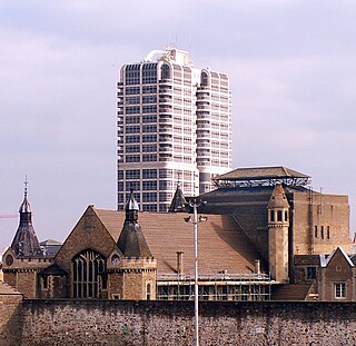
Reading Borough Council is the local authority for the Borough of Reading in the English county of Berkshire. It is a unitary authority, having the powers of a non-metropolitan county and district council combined. Berkshire is purely a ceremonial county, with no administrative responsibilities.

Mapledurham is a small village, civil parish and country estate beside the River Thames in southern Oxfordshire. The large parish borders Caversham the most affluent major district of Reading, Berkshire. All buildings in the village have traditional, rural and/or picturesque views. Significant historic buildings include the Church of England parish church of St. Margaret, Mapledurham Watermill and Mapledurham House.

Lower Caversham is an area of the former town of Caversham, in the English county of Berkshire. Today this is itself a suburb of the larger town of Reading. Lower Caversham has no formal boundaries, but the name usually refers to that part of Caversham situated on lower ground to the east of central Caversham, close to the River Thames.

Caversham Heights is a residential area within Caversham in the English Royal County of Berkshire. Today Caversham is a northern suburb of the larger town of Reading. The name Caversham Heights traditionally refers to that part of Caversham situated on higher ground to the west of central Caversham, straddling the Woodcote Road (A4074). Since 2022, Caversham Heights is also the name of a local government ward that extends to the Thames in the south, and across Hemdean Bottom to St. Barnabas Road in the east.
Milton Keynes Borough Council is the local authority for the Borough of Milton Keynes, a unitary authority in Buckinghamshire, England. Until 1 April 1997 it was a non-metropolitan district.
Abbey is an electoral ward of the Borough of Reading, in the English county of Berkshire. The ruins of Reading Abbey lie within the boundaries of the ward, a fact from which it derives its name. The ward covers the centre of the town, south of the River Thames, and is bordered by Battle, Thames, Redlands, Katesgrove and Coley wards. Although including significant portions of both the suburbs of West Reading and East Reading, the ward lies almost entirely within the Reading East parliamentary constituency, with only a few streets to the west of George Street in the Reading West parliamentary constituency.
Battle is an electoral ward of the Borough of Reading, in the English county of Berkshire. It is situated to the west of the town centre, south of the River Thames, and is bordered by Kentwood, Caversham Heights, Thames, Abbey, Coley, Southcote and Norcot wards.
Caversham is an electoral ward of the Borough of Reading, in the English county of Berkshire. It is to the north of the town centre, in the suburb of Caversham to the north of the River Thames, and is bordered by Thames, Peppard and Abbey wards.
Kentwood is an electoral ward of the Borough of Reading, in the English county of Berkshire. It consists of the northern part of the suburb of Tilehurst, in the west of Reading, south of the River Thames. The ward is bordered by Caversham Heights and Battle wards to the east, and Norcot and Tilehurst wards to the south. To the west the ward is bordered by the reduced civil parish of Tilehurst in the district of West Berkshire which is the remainder of the larger ancient parish, before the expansion of the Borough of Reading. The ward has schools and churches bearing a Tilehurst, rather than Reading name.
Emmer Green is an electoral ward of the Borough of Reading, in the English county of Berkshire. Until the 2022 Reading Borough Council election, it was known as Peppard ward and had slightly different boundaries.
Redlands is an electoral ward of the Borough of Reading, in the English county of Berkshire. It is situated to the south-east of the town centre, and is bordered by Abbey, Park, Church and Katesgrove wards.
Thames was an electoral ward of the Borough of Reading, in the English county of Berkshire, until it was abolished in the boundary changes prior to the 2022 Reading Borough Council election. It should not be confused with the ward of the same name that was created by those boundary changes, but which has no area in common with this former ward.
Reading Borough Council is the council for the unitary authority of Reading in Berkshire, England. Until 1 April 1998 it was a non-metropolitan district.
The 1976 Reading Borough Council election was held on 6 May 1976, at the same time as other local elections across England and Wales. All 46 seats on Reading Borough Council were up for election. The council remained under no overall control, but with the Conservatives becoming the largest party. The Conservative group leader, Deryck Morton, subsequently took the council's most senior political job as chairman of the policy committee, leading a Conservative minority administration.
Caversham Heights is an electoral ward of the Borough of Reading, in the English county of Berkshire. It lies in Caversham, to the north the River Thames, and includes the area known as Caversham Heights, together with other parts of the larger area of Caversham.
References
- ↑ "Wards". Reading Borough Council. Archived from the original on 9 May 2012. Retrieved 5 May 2012.
- ↑ "Final recommendations on the future electoral arrangements for Reading" (PDF). Report to the Electoral Commission. Boundary Committee for England. Archived from the original (PDF) on 4 June 2012. Retrieved 5 May 2012.
- ↑ Explorer Map 159 - Reading (Map). Ordnance Survey. 2006.
- ↑ "Local election results – 6 May 2021". Reading Borough Council. Retrieved 13 June 2022.