Related Research Articles

Reading is a town and borough in Berkshire, England. Most of its built-up area lies within the Borough of Reading, although some outer suburbs are parts of neighbouring local authority areas. Located in the Thames Valley at the confluence of the rivers Thames and Kennet, Reading is 40 miles (64 km) east of Swindon, 25 miles (40 km) south of Oxford, 40 miles (64 km) west of London and 16 miles (26 km) north of Basingstoke.

The Borough of Runnymede is a local government district with borough status in Surrey, England. Its council is based in Addlestone and the borough also includes the towns of Chertsey and Egham. The borough is named after Runnymede, a water meadow on the banks of the River Thames near Egham, which is connected with the sealing of Magna Carta by King John in 1215.

Caversham is a village and suburb of Reading in Berkshire, England, located directly north of Reading town centre across the River Thames. Caversham rises from the River Thames, lying on flood plain and the lowest reaches of the Chiltern Hills. Two road bridges, including Caversham Bridge, and two footbridges join Caversham to the rest of Reading. Named areas within the village include Emmer Green, Lower Caversham, Caversham Heights and Caversham Park Village. Notable landmarks include Caversham Court, a public park and former country house; Caversham Lakes; and part of the Thames Path national trail.
Earley is a town and civil parish in the Borough of Wokingham, Berkshire, England. Along with the neighbouring town of Woodley, the Office for National Statistics places Earley within the Reading/Wokingham Urban Area; for the purposes of local government it falls within the Borough of Wokingham, outside the area of Reading Borough Council. Its name is sometimes spelt Erleigh or Erlegh and consists of a number of smaller areas, including Maiden Erlegh and Lower Earley, and lies some 3 miles (5 km) south and east of the centre of Reading, and some 4 miles (6 km) northwest of Wokingham. It had a population of 32,036 at the 2011 Census.

Caversham Lock is a lock and main weir on the River Thames in England at Reading, Berkshire. Both the lock and main weir are connected to De Bohun Island. The Thames Navigation Commissioners built the original lock in 1778. Additional sluices north of View Island and Heron Island form the whole weir complex. A footbridge, known as The Clappers, passes over the weir and all three islands to connect Lower Caversham to Reading.

Southcote is a suburb of Reading in the English county of Berkshire. Located to the south-west of Reading town centre, Southcote has a population of about 8,500. The settlement lies primarily between the London-to-Bath road and the River Kennet.

Katesgrove is an inner-town district and electoral ward situated immediately to the south of the centre of the town of Reading, in the English county of Berkshire. The district and ward are largely, but not entirely, coterminous.

Lower Caversham is an area of the village of Caversham in Berkshire, England. It forms part of Reading. Lower Caversham has no formal boundaries, but the name usually refers to that part of Caversham situated on lower ground to the east of central Caversham, close to the River Thames. Lower Caversham, as well as the remainder of Reading north of the Thames lies in the historic county of Oxfordshire.

Caversham Court is a public garden and was a mansion located on the north bank of the River Thames in Caversham, a suburb of Reading in the English county of Berkshire. The park lies within the St Peter's conservation area. The park is listed as Grade II in the National Register of Historic Parks and Gardens.
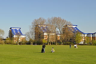
King's Meadow is a park in Reading, Berkshire, England, located next to the River Thames. It stretches from the Coal Woodland to King's Meadow Road near Reading Bridge. The Thames Path long distance footpath runs through the length of King's Meadow, which is visible from the railway when entering or leaving Reading railway station from the eastern side.
Caversham is an electoral ward of the Borough of Reading, in the English county of Berkshire. It is to the north of the town centre, in the suburb of Caversham to the north of the River Thames, and is bordered by Thames, Peppard and Abbey wards.
Kentwood is an electoral ward of the Borough of Reading, in the English county of Berkshire. It consists of the northern part of the suburb of Tilehurst, in the west of Reading, south of the River Thames. The ward is bordered by Caversham Heights and Battle wards to the east, and Norcot and Tilehurst wards to the south. To the west the ward is bordered by the reduced civil parish of Tilehurst in the district of West Berkshire which is the remainder of the larger ancient parish, before the expansion of the Borough of Reading. The ward has schools and churches bearing a Tilehurst, rather than Reading name.
Park is an electoral ward of the Borough of Reading, in the English county of Berkshire. It takes its name from Palmer Park, which lies at its centre.
Emmer Green is an electoral ward of the Borough of Reading, in the English county of Berkshire. Until the 2022 Reading Borough Council election, it was known as Peppard ward and had slightly different boundaries.
Thames was an electoral ward of the Borough of Reading, in the English county of Berkshire, until it was abolished in the boundary changes prior to the 2022 Reading Borough Council election. It should not be confused with the ward of the same name that was created by those boundary changes, but which has no area in common with this former ward.
Reading Borough Council is the council for the unitary authority of Reading in Berkshire, England. Until 1 April 1998 it was a non-metropolitan district. Since the last boundary changes in 2022 the council has comprised 48 councillors representing 16 wards, with each ward electing three councillors. Elections are held three years out of every four, with a third of the council being elected each time for a four-year term.
Caversham Heights is an electoral ward of the Borough of Reading, in the English county of Berkshire. The ward was created by a boundary reorganisation prior to the 2022 Reading Borough Council election, and has replaced the Mapledurham ward, with the addition of parts of the old Thames and Peppard wards. During the reorganisation process, the ward was known as The Heights, but the name was subsequent changed as a result of public consultation.

Christchurch Meadows is a park in Reading, Berkshire, England, located next to the River Thames. It stretches along the north (Caversham) side of the river, between Caversham Bridge and Reading Bridge, and is linked to the south (Reading) bank by the Christchurch Bridge, a pedestrian and cycle bridge built in 2015. The name of the meadow derives from Christ Church in Oxford, whose dean owned 25 acres (10 ha) of farmland in Reading.
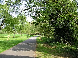
Hills Meadow is a park in Reading, Berkshire, England, located next to the River Thames. It stretches along the north (Caversham) side of the river, to the east of Reading Bridge. It is linked to the south (Reading) bank by a footpath, locally known as The Clappers that crosses View Island and the weir at Caversham Lock.

Thameside Promenade, or Thames Side Promenade, is a public park and promenade in Reading, Berkshire, England, located next to the River Thames. It stretches along the south (Reading) side of the river, to the west of Caversham Bridge, and forms part of the Thames Path long distance footpath. The park includes grassland behind the promenade.
References
- 1 2 3 Election Maps (Map). Ordnance Survey. Retrieved 27 June 2022.
- ↑ "Your Councillors". Reading Borough Council. Archived from the original on 9 June 2022. Retrieved 27 June 2022.