The Antarctic is a polar region around Earth's South Pole, opposite the Arctic region around the North Pole.
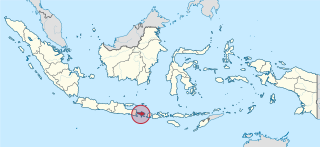
Bali is a province of Indonesia and the westernmost of the Lesser Sunda Islands. East of Java and west of Lombok, the province includes the island of Bali and a few smaller offshore islands, notably Nusa Penida, Nusa Lembongan, and Nusa Ceningan to the southeast. The provincial capital, Denpasar, is the most populous city in the Lesser Sunda Islands and the second-largest, after Makassar, in Eastern Indonesia. The upland town of Ubud in Greater Denpasar is considered Bali's cultural centre. The province is Indonesia's main tourist destination, with a significant rise in tourism since the 1980s. Tourism-related business makes up 80% of its economy.

Long Island is a densely populated island in southeastern New York State, constituting a significant share of the New York metropolitan area in terms of both population and land area. With over eight million inhabitants as of 2020, it is the most populous island in the United States and the 18th-most populous island in the world. Just 0.35 miles from Manhattan at its western end, the island begins at New York Harbor and extends 118 miles (190 km) eastward to the North Atlantic Ocean with a maximum north-south width of 23 miles (37 km). Long Island's land area of 1,401 square miles (3,630 km2) makes it the largest island in the contiguous United States, 11th-largest in the nation, and 149th-largest in the world.

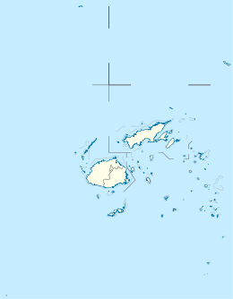
Oceania is a geographical region that is described as a continent in some parts of the world. It includes Australasia, Melanesia, Micronesia, and Polynesia. Spanning the Eastern and Western Hemispheres, Oceania is estimated to have a land area of 8,525,989 square kilometres (3,291,903 sq mi) and a population of around 44.4 million as of 2022. Oceania is described as a geographical region in most of the English-speaking world, but outside of the English-speaking world, Oceania is described as one of the continents. In this model of the world, Australia is only seen as an island nation contained inside of the continent of Oceania, and not a continent by itself. When compared to the other continents, Oceania is the smallest in land area and the second least populated after Antarctica.

The Pacific Ocean is the largest and deepest of Earth's five oceanic divisions. It extends from the Arctic Ocean in the north to the Southern Ocean in the south, and is bounded by the continents of Asia and Oceania in the west and the Americas in the east.

The Andaman and Nicobar Islands is a union territory of India consisting of 571 islands, of which 37 are inhabited, at the junction of the Bay of Bengal and the Andaman Sea. The territory is about 150 km (93 mi) north of Aceh in Indonesia and separated from Thailand and Myanmar by the Andaman Sea. It comprises two island groups, the Andaman Islands (partly) and the Nicobar Islands, separated by the 150 km wide Ten Degree Channel, with the Andaman islands to the north of this latitude, and the Nicobar islands to the south. The Andaman Sea lies to the east and the Bay of Bengal to the west. The island chains are thought to be a submerged extension of the Arakan Mountains.

Alcatraz Island is a small island 1.25 miles (2.01 km) offshore from San Francisco, California, United States. The island was developed in the mid-19th century with facilities for a lighthouse, a military fortification, and a military prison. In 1934, the island was converted into a federal prison, Alcatraz Federal Penitentiary. The strong currents around the island and cold water temperatures made escape nearly impossible, and the prison became one of the most notorious in American history. The prison closed in 1963, and the island is now a major tourist attraction.
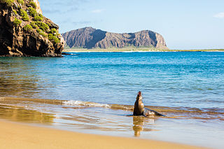
The Galápagos Islands are an archipelago of volcanic islands in the Eastern Pacific, located around the Equator 900 km (560 mi) west of South America. They form the Galápagos Province of the Republic of Ecuador, with a Spanish-speaking population of slightly over 33,000 (2020). The province is divided into the cantons of San Cristóbal, Santa Cruz, and Isabela, the three most populated islands in the chain. The Galápagos are famous for their large number of endemic species, which were studied by Charles Darwin in the 1830s and inspired his theory of evolution by means of natural selection. Many of the islands are protected as part of Ecuador's Galápagos National Park and Marine Reserve.

The British Overseas Territories (BOTs), also known as the United Kingdom Overseas Territories (UKOTs), are fourteen territories with a constitutional and historical link with the United Kingdom, but do not form part of the United Kingdom itself. The permanently inhabited territories are internally self-governing, with the United Kingdom retaining responsibility for defence and foreign relations. All of the territories are inhabited by civilians, except 3 which are chiefly or only inhabited by a population of military or scientific personnel. All fourteen have the British monarch as head of state. These UK government responsibilities are assigned to various departments of the Foreign, Commonwealth and Development Office and are subject to change.

An unincorporated area is a region that is not governed by a local municipal corporation. Widespread unincorporated communities and areas are a distinguishing feature of the United States and Canada. Most other countries of the world either have no unincorporated areas at all or these are very rare. They are typically remote, outlying, sparsely populated or uninhabited areas.

The states and territories are administrative divisions in Australia, ruled by regional governments that constitute the level of governance between the federal government and local governments. States are self-governing polities with incomplete sovereignty and their own constitutions, legislatures, departments, and certain civil authorities that administer and deliver most public policies and programs. Territories can be autonomous and administer local policies and programs much like the states in practice, but are still constitutionally and financially subordinate to the federal government and thus have no true sovereignty.

The West Indies is a subregion of North America, surrounded by the North Atlantic Ocean and the Caribbean Sea, which comprises 13 independent island countries and 18 dependencies in three archipelagos: the Greater Antilles, the Lesser Antilles, and the Lucayan Archipelago.

Great Britain is an island in the North Atlantic Ocean off the north-west coast of continental Europe. With an area of 209,331 km2 (80,823 sq mi), it is the largest of the British Isles, the largest European island and the ninth-largest island in the world. It is dominated by a maritime climate with narrow temperature differences between seasons. The island of Ireland, with an area 40 per cent that of Great Britain, is to the west—these islands, along with over 1,000 smaller surrounding islands and named substantial rocks, form the British Isles archipelago.

Newfoundland is a large island situated off the eastern coast of the North American mainland and the most populous part of the Canadian province of Newfoundland and Labrador. The island contains 29 percent of the province's land area. The island is separated from the Labrador Peninsula by the Strait of Belle Isle and from Cape Breton Island by the Cabot Strait. It blocks the mouth of the Saint Lawrence River, creating the Gulf of Saint Lawrence, the world's largest estuary. Newfoundland's nearest neighbour is the French overseas collectivity of Saint Pierre and Miquelon.