Alexander Emmanuel Rodolphe Agassiz, son of Louis Agassiz and stepson of Elizabeth Cabot Agassiz, was an American scientist and engineer.

The Western Pacific nation of Tuvalu, formerly known as the Ellice Islands. It is situated 4,000 kilometers (2,500 mi) northeast of Australia and is approximately halfway between Hawaii and Australia. It lies east-northeast of the Santa Cruz Islands, southeast of Nauru, south of Kiribati, west of Tokelau, northwest of Samoa and Wallis and Futuna and north of Fiji. It is a very small island country of and is 26 km2 (10 sq mi). Due to the spread out islands it has the 38th largest Exclusive Economic Zone of 749,790 km2 (289,500 sq mi).

An atoll, sometimes known as a coral atoll, is a ring-shaped coral reef, including a coral rim that encircles a lagoon partially or completely. There may be coral islands or cays on the rim.
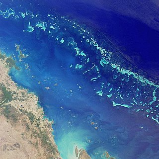
The Great Barrier Reef is the world's largest coral reef system composed of over 2,900 individual reefs and 900 islands stretching for over 2,300 kilometres (1,400 mi) over an area of approximately 344,400 square kilometres (133,000 sq mi). The reef is located in the Coral Sea, off the coast of Queensland, Australia. The Great Barrier Reef can be seen from outer space and is the world's biggest single structure made by living organisms. This reef structure is composed of and built by billions of tiny organisms, known as coral polyps. It supports a wide diversity of life and was selected as a World Heritage Site in 1981. CNN labelled it one of the seven natural wonders of the world. The Queensland National Trust named it a state icon of Queensland.

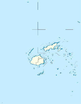
Taveuni is the third-largest island in Fiji, after Viti Levu and Vanua Levu, with a total land area of 434 square kilometres. The cigar-shaped island, a massive shield volcano which rises from the floor of the Pacific Ocean, is situated 6.5 kilometres to the east of Vanua Levu, across the Somosomo Strait. It belongs to the Vanua Levu Group of islands and is part of Fiji's Cakaudrove Province within the Northern Division.
Ogea Levu is a coral island on a barrier reef in Fiji's Southern Lau archipelago. With an area of 13.3 square kilometres, it is situated at 19.18° South and 178.47° West, 10 kilometres (6.2 mi) east of Fulaga. It has a maximum altitude of 82 metres (270 ft).

Wailagi Lala is the northernmost outpost of Fiji's Lau Islands. This tiny atoll, with an area of just 30 hectares and rising no more than 3 metres (10 ft) above mean sea level, is situated at 16.45° South and 179.6° West. It is the only true atoll in Fiji.
The Ringgold Isles are an archipelago in Fiji, forming an outlier group to Vanua Levu. The Budd, Nukusemanu, and Heemskercq Reefs form part of the group. The group is mostly uninhabited, but Qelelevu has a small village. In 2008 Pacific Rats were eradicated from seven islands of the group in an endeavour facilitated by BirdLife International's Fiji Programme.
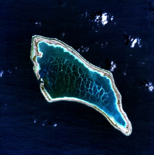
Qelelevu is a coral islet in Fiji, a member of the Ringgold Isles archipelago, which forms an outlier to the northern island of Vanua Levu. Apart from two nearby coral islets, Tai Ni Beka and Tauraria due west on the same atoll rim, it is 30 kilometres (19 mi) from the nearest island, which is Vetauua, to the West. Qelelevu covers an area of 1.5 square kilometers. Its maximum elevation is 12 metres (39 ft).

The Mamanuca Islands of Fiji are a volcanic archipelago lying to the west of Nadi and to the south of the Yasawa Islands. The group, a popular tourist destination, consists of about 20 islands, but about seven of these are covered by the Pacific Ocean at high tide.
Raranitiqa Island in Fiji, a member of the Ringgold Isles archipelago, which forms an outlier group to the northern island of Vanua Levu. It is located within the Budd Reef and large formations of rocks, known as the Gangway rocks, make navigation around the island dangerous at night. It has a land area of 2.49 hectares. The southern part of the island has a "well-defined summit."
The Rainbow Reef is a reef in the Somosomo Strait between the Fijian islands of Taveuni and Vanua Levu. It is one of the most famous dive sites in the South Pacific. The Great White Wall is a popular scuba diving site. It is named because of the white coral inhabiting the area at depths between 15 and 65 metres.

The habitat of deep-water corals, also known as cold-water corals, extends to deeper, darker parts of the oceans than tropical corals, ranging from near the surface to the abyss, beyond 2,000 metres (6,600 ft) where water temperatures may be as cold as 4 °C (39 °F). Deep-water corals belong to the Phylum Cnidaria and are most often stony corals, but also include black and horny corals and soft corals including the Gorgonians. Like tropical corals, they provide habitat to other species, but deep-water corals do not require zooxanthellae to survive.

The Coral Triangle (CT) is a roughly triangular area of the tropical marine waters of Indonesia, Malaysia, Papua New Guinea, Philippines, Solomon Islands and Timor-Leste that contain at least 500 species of reef-building corals in each ecoregion. CT located in equator, between Pacific and Indian Ocean that encompasses portions of two biogeographic regions: the Indonesian-Philippines Region, and the Far Southwestern Pacific Region. As part of eight major coral reef reef zone in the world, CT is recognized as the global centre of marine biodiversity and a global priority for conservation. It is also called the "Amazon of the seas" and covers 5.7 million square kilometres (2,200,000 sq mi) of ocean waters. Its biological resources categorize as a global hotspot of marine biodiversity that contains >76% of the world's shallow-water reef-building coral species, 37% of the world's reef fishes, 50% of razor clams, six out of seven of the world's sea turtles, and the largest mangrove forest in the world. In 2014, the Asian Development Bank (ADB) reported a gross domestic product of the marine ecosystem in CT reaches $1.2 trillion per year for over 120 million people. According to the Coral Triangle Knowledge Network, about $3 billion in fisheries exports and another $3 billion in coastal tourism revenues are derived as annual foreign exchange income in the region.
The Structure and Distribution of Coral Reefs, Being the first part of the geology of the voyage of the Beagle, under the command of Capt. Fitzroy, R.N. during the years 1832 to 1836, was published in 1842 as Charles Darwin's first monograph, and set out his theory of the formation of coral reefs and atolls. He conceived of the idea during the voyage of the Beagle while still in South America, before he had seen a coral island, and wrote it out as HMS Beagle crossed the Pacific Ocean, completing his draft by November 1835. At the time there was great scientific interest in the way that coral reefs formed, and Captain Robert FitzRoy's orders from the Admiralty included the investigation of an atoll as an important scientific aim of the voyage. FitzRoy chose to survey the Keeling Islands in the Indian Ocean. The results supported Darwin's theory that the various types of coral reefs and atolls could be explained by uplift and subsidence of vast areas of the Earth's crust under the oceans.
The Great Astrolabe Reef is in Fiji and surrounds the fourth largest island, Kadavu Island, which is approximately 65 km in length. Kadavu Island is approximately 100 km south of Viti Levu, the main island of Fiji.

Cakaulevu Reef is a coral reef located off the northern shore of the island of Vanua Levu in Fiji. It is the third longest continuous barrier reef in the world after the Great Barrier Reef in Australia and the Mesoamerican Reef off Central America. When combined with the nearby Pascoe Reef, Cakaulevu Reef is about 200 kilometres (120 mi) long. On its own, the Cakaulevu Reef covers 202,700 square kilometres (78,300 sq mi).
The Funafuti Conservation Area is a marine conservation area covering 33 square kilometers of reef, lagoon and motu (islets) on the western side of Funafuti atoll in Tuvalu. The marine environment of the conservation area includes reef, lagoon, channel and ocean; and are home to many species of fish, corals, algae and invertebrates. The islets are nesting sites for the green sea turtle and Fualopa hosts a breeding colony of black noddy.

Viwa Island, Yasawa is located approximately 70 km northwest of Denarau situated in the Yasawa Islands of Fiji.
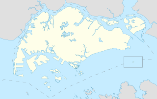
Sisters’ Islands Marine Park is a 400,000 square metre(40ha) marine park located in Southern Islands planning area, Singapore. The park encompasses the land and waters surrounding Sisters' Islands, and also covers the western coasts of both St John's Island and Pulau Tekukor.