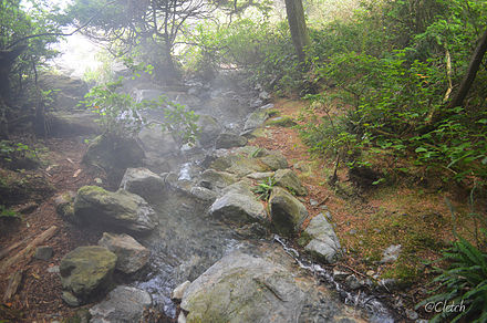
Liard River Hot Springs Provincial Park is a provincial park in British Columbia, Canada. It is home to the largest natural hot springs in Canada. It is a natural river of hot water rather than a spring fed man made pool The park is part of the larger Muskwa-Kechika Management Area. The community of Liard River, British Columbia is located nearby.
Cody Caves Provincial Park is a provincial park in British Columbia, Canada. It was formed in July 1966 to protect the Cody Caves and was the first subterranean park in British Columbia. The park is 13 km by road, northwest from the hot springs community of Ainsworth on Kootenay Lake.
Choquette Hot Springs Provincial Park is a provincial park in the Stikine Country region of northwestern British Columbia, Canada. Despite the park's name, the official and most commonly used name of the springs it was established to protect is Stikine River Hot Springs. The park gets its name by the springs' proximity to Choquette Bar, site of the first gold strike of the Stikine Gold Rush of 1861 and named for Alexander "Buck" Choquette, the strike's discoverer.

Duffey Lake Provincial Park is a provincial park in British Columbia, Canada, located at the lake of the same name, which lies along BC Highway 99 just east of the summit of Cayoosh Pass. The lake's inflow and outflow are Cayoosh Creek.
Epper Passage Provincial Park is a provincial park in British Columbia, Canada, located on the north side of Vargas Island in the Clayoquot Sound region of the West Coast of Vancouver Island, British Columbia, Canada. Also on Vargas Island is Vargas Island Provincial Park. Other provincial parks nearby are Flores Island Marine Provincial Park, Gibson Marine Provincial Park, Maquinna Marine Provincial Park, Sydney Inlet Provincial Park, Dawley Passage Provincial Park and Hesquiat Peninsula Provincial Park. The park was created as part of the Clayoquot Land-Use Decision on July 13, 1995 and contains approximately 306 ha.
Flores Island Marine Provincial Park, also known as Flores Island Provincial Park, is a provincial park in British Columbia, Canada, located on the island of the same name in the central Clayoquot Sound region of the West Coast of Vancouver Island, British Columbia, Canada. The park contains 7113 ha. and was created on July 13, 1995 as part of the Clayoqout Land-Use Decision. Gibson Marine Provincial Park, which was created in 1967, adjoins it to the southeast. Sulphur Passage Provincial Park is off the northeast coast of Flores Island, surrounding Obstruction Island.

Gibson Marine Provincial Park is a provincial park in British Columbia, Canada, located on the southeast end of Flores Island in the central Clayoquot Sound region of Vancouver Island. The park was created on 13 November 1967. It contains approximately 143 hectares and is adjacent to Flores Island Provincial Park.
Nicolum River Provincial Park, formerly Nicolum Provincial Park, is a provincial park in British Columbia, Canada, located at the confluence of the Nicolum and Coquihalla Rivers near the town of Hope. The park is a Class A, category 6 Provincial Park.
Oliver Cove Marine Provincial Park, also known as Port Blackney, is a provincial park at the southwest end of the Don Peninsula on the North Coast of British Columbia, Canada. It is accessible only by boat, but lacks docks or other facilities. The park comprises 26 hectares of marine area and 48 hectares of land area.

Pirates Cove Marine Provincial Park is a provincial park on De Courcy Island in British Columbia, Canada.
Santa Gertrudis-Boca del Infierno Provincial Park, legally Santa-Boca Provincial Park, is a provincial park in British Columbia, Canada. It is located on the southeast side of Nootka Sound. The park's name derives from that of Boca del Infierno Bay and Santa Gertrudis Cove. Boca del Infierno means "Bay of Fury" or "Bay of Hell" while Santa Gertrudis Cove is from the Spanish name for Saint Gertrude.
Silver Lake Provincial Park is a provincial park in British Columbia, Canada, located in the Skagit River Valley just south of Hope and comprising 77 ha.

Smuggler Cove Marine Provincial Park is a provincial park in British Columbia, Canada.

Yuquot, also known as Fort San Miguel or Friendly Cove, is a small settlement of around six people - The Williams family of the Mowachaht band, plus two full-time lighthouse keepers, located on Nootka Island in Nootka Sound, just west of Vancouver Island, British Columbia, Canada. It was the summer home of Chief Maquinna and the Mowachaht/Muchalaht (Nuu-chah-nulth) people for generations, housing approximately 1,500 natives in 20 traditional wooden longhouses. The name means "Wind comes from all directions" in Nuu-chah-nulth.

Hot Springs Cove, formerly Refuge Cove, is an unincorporated settlement on Sydney Inlet on the west side of the Openit Peninsula in the western Clayoquot Sound region of the West Coast of Vancouver Island. Hot Springs Cove derives its name from its proximity to Ramsay Hot Springs, and is protected by Maquinna Marine Provincial Park. The post office at Hot Springs Cove was closed in 1974 but had operated since 1947, when it was first named Sydney Inlet until being renamed in 1948. Despite the closure of the post office, there remains a year-round population in the vicinity.
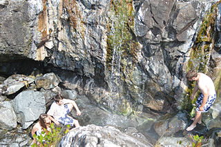
Ramsay Hot Springs is a hot spring in the western Clayoquot Sound region of the West Coast of Vancouver Island, British Columbia, Canada, located north of Sharp Point to the west of Sydney Inlet. The hot springs are the namesake of the community and cove of Hot Springs Cove and are protected by Maquinna Marine Provincial Park. They are accessible only by boat or float plane, and are open year-round.
Musket Island Marine Provincial Park is a provincial park in British Columbia, Canada, located on the west side of Nelson Island, at the mouth of Jervis Inlet and near Earl's Cove in the Sunshine Coast region.

The Terminal Range is the northernmost mountain range of the Canadian Rockies, so-named for its position at the northern terminus of the Rockies. Lying west of Muncho Lake and the Trout River, its northern perimeter is the Liard River. The Sentinel Range lies to its east.
The Trout River is a tributary of the Liard River in far northern British Columbia, Canada, flowing northwest from headwaters at 58°44′N126°14′W, near Muncho Lake, to meet the Liard at the community of Liard River. It is at the upper end of the Grand Canyon of the Liard, which is part of Liard River Corridor Provincial Park and Protected Area.