Hot Springs Cove, British Columbia

Last updated
Hot Springs Cove
Maquinna Marine Provincial Park (15077242615).jpg
Dock at Hot Springs Cove
Canada British Columbia location map 2.svg
Red pog.svg
Hot Springs Cove
Location of Hot Springs Cove in British Columbia
Coordinates: 49°22′00″N126°15′45″W / 49.36667°N 126.26250°W / 49.36667; -126.26250 Coordinates: 49°22′00″N126°15′45″W / 49.36667°N 126.26250°W / 49.36667; -126.26250
CountryFlag of Canada.svg  Canada
Province Flag of British Columbia.svg  British Columbia
Area code(s) 250, 778

Hot Springs Cove, formerly Refuge Cove, is an unincorporated settlement on Sydney Inlet on the west side of the Openit Peninsula in the western Clayoquot Sound region of the West Coast of Vancouver Island. Hot Springs Cove derives its name from its proximity to Ramsay Hot Springs, and is protected by Maquinna Marine Provincial Park. The post office at Hot Springs Cove was closed in 1974 but had operated since 1947, when it was first named Sydney Inlet until being renamed in 1948. Despite the closure of the post office, there remains a year-round population in the vicinity.

Clayoquot Sound Canadian body of water with many inlets and islands

Clayoquot Sound is located on the west coast of Vancouver Island in the Canadian province of British Columbia. It is bordered by the Esowista Peninsula to the south, and the Hesquiaht Peninsula to the North. It is a body of water with many inlets and islands. Major inlets include Sydney Inlet, Shelter Inlet, Herbert Inlet, Bedwell Inlet, Lemmens Inlet, and Tofino Inlet. Major islands include Flores Island, Vargas Island, and Meares Island. The name is also used for the larger region of land around the waterbody.

Vancouver Island Island on the western coast of Canada

Vancouver Island is in the northeastern Pacific Ocean. It is part of the Canadian province of British Columbia. The island is 460 kilometres (290 mi) in length, 100 kilometres (62 mi) in width at its widest point, and 32,134 km2 (12,407 sq mi) in area. It is the largest island on the West Coast of the Americas.

Ramsay Hot Springs

Ramsay Hot Springs is a hot spring in the western Clayoquot Sound region of the West Coast of Vancouver Island, British Columbia, Canada, located north of Sharp Point to the west of Sydney Inlet. The hot springs are the namesake of the community and cove of Hot Springs Cove and are protected by Maquinna Marine Provincial Park. They are accessible only by boat or float plane, and are open year-round.

Contents

See also

Sydney Inlet Provincial Park is a provincial park in the Clayoquot Sound region of the west coast of Vancouver Island, British Columbia, Canada, located north of the settlement of Hot Springs Cove and northwest of the resort town of Tofino. Sydney Inlet was the name of the post office in the area from its creation in 1947 to 1948, when it was renamed Hot Springs Cove, though that post office was subsequently closed in 1974.

Gibson Marine Provincial Park

Gibson Marine Provincial Park is a provincial park in British Columbia, Canada, located on the southeast end of Flores Island in the central Clayoquot Sound region of Vancouver Island. The park was created on 13 November 1967. It contains approximately 143 hectares and is adjacent to Flores Island Provincial Park.

Hesquiat Peninsula Provincial Park is a provincial park at the western extremity of the Clayoquot Sound region of the West Coast of Vancouver Island, British Columbia, Canada. The Hesquiat Peninsula forms the division between the Clayoquot Sound region, to the south, and the Nootka Sound region to the north. The park contains 7,898 ha. and was created as part of the Clayoquot Land-Use Decision. The peninsula is named for the Hesquiaht group of the Nuu-chah-nulth peoples. Hesquiat Indian Reserve No. 1 and adjoining locality and former steamer landing of Hesquiat are located on its southeastern tip. Estevan Point, a lighthouse that was the setting for one of the few Japanese military attacks on North America in World War II, is on the southwestern tip.

Related Research Articles

Comox-Strathcona Regional District geographical object

The Regional District of Comox-Strathcona was a regional district of British Columbia, Canada from 1967 to 2008. On February 15, 2008, the regional district was abolished and replaced by two successor regional districts, Comox Valley and Strathcona.

Earls Cove, British Columbia Locality in British Columbia, Canada

Earls Cove is a small settlement located on Jervis Inlet in the Sunshine Coast region of British Columbia. It is a terminal for the BC Ferries route across the inlet to Saltery Bay, linking the Lower Sunshine Coast with the Upper Sunshine Coast. Earls Cove is the at the north end of the Sechelt Peninsula and on the east side of the mouth of Jervis Inlet, adjacent to Agamemnon Channel, across which is Nelson Island.

Jervis Inlet

Jervis Inlet is one of the principal inlets of the British Columbia Coast, about 95 km (59 mi) northwest of Vancouver, and the third of such inlets north of the 49th parallel north, the first of which is the Burrard Inlet, Vancouver's harbour. .

Liard River Hot Springs Provincial Park provincial park in British Columbia, Canada

Liard River Hot Springs Provincial Park is a provincial park in British Columbia, Canada. It is home to the largest natural hot springs in Canada. It is a natural river of hot water rather than a spring fed man made pool The park is part of the larger Muskwa-Kechika Management Area. The community of Liard River, British Columbia is located nearby.

Brooks Peninsula Provincial Park provincial park

Parts of this article have been adapted from the BC Parks website.

Epper Passage Provincial Park is a provincial park in British Columbia, Canada, located on the north side of Vargas Island in the Clayoquot Sound region of the West Coast of Vancouver Island, British Columbia, Canada. Also on Vargas Island is Vargas Island Provincial Park. Other provincial parks nearby are Flores Island Marine Provincial Park, Gibson Marine Provincial Park, Maquinna Marine Provincial Park, Sydney Inlet Provincial Park, Dawley Passage Provincial Park and Hesquiat Peninsula Provincial Park. The park was created as part of the Clayoquot Land-Use Decision on July 13, 1995 and contains approximately 306 ha.

Harmony Islands Marine Provincial Park

Harmony Islands Marine Provincial Park is a provincial park in British Columbia, Canada, located on the east side of Hotham Sound, which is a side-inlet of the lower reaches of Jervis Inlet, on that inlet's north side roughly opposite the mouth of Sechelt Inlet.

Maquinna Marine Provincial Park

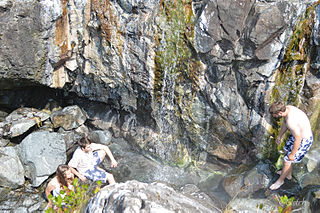
Maquinna Marine Provincial Park is a provincial park in British Columbia, Canada, located northwest of Tofino in the Clayoquot Sound region of the West Coast of Vancouver Island, protecting Ramsay Hot Springs, which is the name-source of the cove, settlement and former post office of Hot Springs Cove.

Oliver Cove Marine Provincial Park, also known as Port Blackney, is a provincial park at the southwest end of the Don Peninsula on the North Coast of British Columbia, Canada. It is accessible only by boat, but lacks docks or other facilities. The park comprises 26 hectares of marine area and 48 hectares of land area.

Penrose Island Marine Provincial Park

Penrose Island Marine Provincial Park is a provincial park in the Central Coast region of British Columbia, Canada, located on the north side of the entrance to Rivers Inlet, 86 km north of Port Hardy at the south end of Fitz Hugh Sound. Comprising 1,079 hectares of marine area and 934 hectares of land area, the park is accessible by boat only and entrance to its anchorages are on its eastern side, the western being exposed to the open ocean. Exploration by dinghy and kayak are popular with visitors, as are nature viewing, scuba diving and exploring the islands many beaches and adjoining islets. The nearest supply centre for fuel and food is at the community of Rivers Inlet.

Princess Louisa Marine Provincial Park is a provincial park in British Columbia, Canada surrounding Princess Louisa Inlet.

Smuggler Cove Marine Provincial Park provincial park of British Columbia, Canada

Smuggler Cove Marine Provincial Park is a provincial park in British Columbia, Canada.

West Redonda Island island

West Redonda Island is an island in British Columbia, Canada. It is part of the Discovery Islands, an archipelago between Vancouver Island and the mainland, and between the Strait of Georgia and Johnstone Strait.

Simoom Sound, British Columbia Place in British Columbia, Canada

Simoom Sound is a post office located at Echo Bay, British Columbia, Canada, on Gilford Island in the Central Coast region adjacent to the body of water of the same name, which was named for HMS Simoom. The name formerly applied to a location on the nearby Wishart Peninsula as a steamer landing but was moved to Echo Bay when the former location became depopulated.

Musket Island Marine Provincial Park is a provincial park in British Columbia, Canada, located on the west side of Nelson Island, at the mouth of Jervis Inlet and near Earl's Cove in the Sunshine Coast region.

Terminal Range

The Terminal Range is the northernmost mountain range of the Canadian Rockies, so-named for its position at the northern terminus of the Rockies. Lying west of Muncho Lake and the Trout River, its northern perimeter is the Liard River. The Sentinel Range lies to its east.

Tofino District municipality in British Columbia, Canada

Tofino is a district of approximately 1,932 residents on the west coast of Vancouver Island in the Canadian province of British Columbia. The district is located at the western terminus of Highway 4 on the tip of the Esowista Peninsula at the southern edge of Clayoquot Sound.

References

The BC Geographical Names is a geographic name web service and database for the Canadian province of British Columbia run by the Base Mapping and Geomatic Services Branch of the Integrated Land Management Bureau. The database contains official names and spellings of towns, mountains, rivers, lakes, and other geographic places. The database often has other useful information, such as the history of geographic names, and their use in history.