
Gloucester is a suburb in the City of Ottawa. Gloucester Township was established in 1792 and originally included lands east of the Rideau River from the Ottawa River south to Manotick. It was incorporated as a township in 1850 and became a city in 1981. Gloucester was one of the 11 municipalities that merged in 2001 to form the new city of Ottawa. As of the Canada 2016 Census, the former city of Gloucester had a population of 133,280.
Cumberland is a former municipality and now geographic township in eastern Ontario, Canada. It was an incorporated township from 1800 to 1999, when it was incorporated as the City of Cumberland, then ceased to be a separate municipality in 2001, when it was amalgamated into the city of Ottawa. It now exists only as a geographic township.

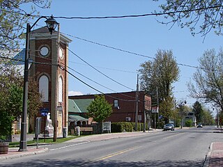
Richmond is a village and former municipality within the city limits of Ottawa, Ontario, Canada. Founded in 1818, it spans the Jock River, a tributary of the Rideau River. Like many communities in eastern Ontario, Richmond houses several unique populations. Some residents have historic and economic roots in the immediate area. Richmond operates as a small core to its residents. To others, the village serves as a bedroom community for the larger urban area of Ottawa. Richmond is 15 km from North Gower, 32 km from Carleton Place, 36 km from Downtown Ottawa, 41 km from Smiths Falls and 45 km from Perth. Its population at the Canada 2006 Census was 3,301.

Carleton County is the name of a historic county in Ontario, Canada. In 1969, it was superseded by the Regional Municipality of Ottawa–Carleton. In 2001, the Regional Municipality and its eleven local municipalities were replaced by the current City of Ottawa.
The Regional Municipality of Ottawa–Carleton was a regional government area and census division in Ontario, Canada, which existed from 1969 until 2001. It was created in 1969 from the former Carleton County plus Cumberland Township, previously part of Russell County.
Russell County is a historic county in the Canadian province of Ontario.

Osgoode Township is a former township that is now a part of the city of Ottawa, Ontario, Canada. The township along the Rideau River was established in 1798 and incorporated in 1850. It was an independent township in Carleton County until its amalgamation with the city in 2001. It remains a largely rural area with only some 23,285 inhabitants as of the 2016 census. On Ottawa city council it is represented by George Darouze.

Carleton is a federal electoral district in Ontario, Canada, represented in the House of Commons of Canada from 1867 to 1968 and since 2015. It was represented in the Legislative Assembly of Upper Canada from 1821 to 1840 and in the Legislative Assembly of the Province of Canada from 1841 until 1866.
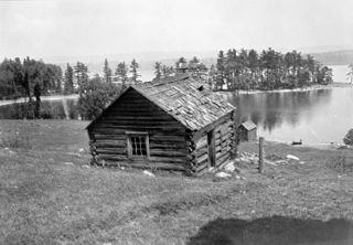
Horaceville is a historic site located on the Ottawa River in eastern Ontario, Canada. The site remained the property of the heirs of Hamnett Kirkes Pinhey until the 1970s, when the property was sold to the township. Today, The 88-acre (360,000 m2) heritage site is owned and operated by the City of Ottawa and Pinhey's home serves as a museum. The museum is open May 14 through August 31, Wednesdays to Sundays, 11 am to 5 pm. This location is also known as Pinhey's Point Historic Site. The property was designated by the City of Ottawa under Part IV of the Ontario Heritage Act as having cultural heritage value or interest. A bronze plaque erected on the site by the Ontario Heritage Foundation describes the property's history: "Hamnet Kirkes Pinhey 1784 - 1857 - A merchant and ship owner in his native England, Pinhey came to Upper Canada in 1820. For his services as King's messenger during the Napoleonic Wars, he received a 1000 acres land grant on the Ottawa River. Within a decade he had built up an estate which he named Horaceville after his elder son. In addition to a manor house and barns, it included mills, a store and church. Pinhey took a leading part in township and district affairs. He was appointed to the Legislative Council in 1847, served as Warden of the Dalhousie District, and as the first Warden of Carleton County. Horaceville remained in family hands until 1959 when it was purchased by the National Capital Commission."
Dunrobin is a community in West Carleton-March Ward in the City of Ottawa, Ontario, Canada. It is located about 35 kilometres northwest of Downtown Ottawa. Dunrobin lies within a valley, nestled between the Ottawa River and the Carp escarpment, and is located at 45.18° latitude and 75.55° longitude. Dunrobin is located on the former boundary between West Carleton Township and Kanata. Dunrobin was amalgamated with the city of Ottawa in 2000. Dunrobin is expanding steadily with a current population of about 1,000 people.
Nepean Township is a former incorporated and now geographic township in Eastern Ontario, Canada, now part of the City of Ottawa.
Hamnett Kirkes Pinhey was a Canadian landowner and politician.
Marlborough Township is a former incorporated and now geographic township in eastern Ontario, Canada.
Fitzroy is a former incorporated and present day geographic township originally part of Carleton County in eastern Ontario, Canada.
Hamnett Pinhey Hill was an Ontario lawyer and political figure. He represented Ottawa West in the Legislative Assembly of Ontario from 1919 to 1923 as a Conservative member.

This is the outline of the geography of the city of Ottawa, the capital of Canada. Ottawa's current borders were formed in 2001, when the former city of Ottawa amalgamated with the ten other municipalities within the former Regional Municipality of Ottawa–Carleton. Ottawa is now a single-tiered census division, home to 870,250 people.

The Ottawa Catholic School Board is a publicly funded separate school board in Ottawa, Ontario, Canada. Its headquarters are in the Nepean area of Ottawa.
Robert Malcomson was born 8 July 1795 in County Cavan, Ireland. He emigrated to Upper Canada about 1819 as a "military emigrant". He married Catherine Stevenson (1799–1853) and together they had seven children - Jane Stinson (1822-), Joseph (1824–1905), Ann Watt (1825–1904), Robert (1825–1905), Sarah Hartin (1830–1904), James (1854-), and Elizabeth? (1836-). Robert Malcomson died 28 March 1868 and was buried in South March two days later. He left his sons Joseph and Robert $1.00 each, and his daughters Jane Stinson, Ann Watt, Sarah Hartin and Eliza Malcolm (sic) $0.25 each. As well Joseph got 5 acres of Lot 11, Concession 2. The rest of his land, goods, etc. went to son James, who was his executor.

Kanata—Carleton is a federal electoral district in Ottawa, Ontario.
Carleton is a provincial riding in Ontario, Canada. It was created in 1867 at the time of confederation and lasted until provincial redistribution in 1996. In the 1999 provincial election it was redistributed into Nepean—Carleton and Lanark—Carleton. In 2007 it was abolished into Carleton—Mississippi Mills and Lanark—Frontenac—Lennox and Addington.
