
Gloucester is a former municipality and now geographic area of Ottawa, Ontario, Canada. Located east of Ottawa's inner core, it was an independent city until amalgamated with the Regional Municipality of Ottawa–Carleton in 2001 to become the new city of Ottawa. The population of Gloucester is about 150,012 people.

Richmond is a suburban community, part of the Canadian capital of Ottawa, Ontario, Canada. Founded in 1818, it spans the Jock River, a tributary of the Rideau River. A part of the National Capital Region, Richmond is located 10 kilometres (6.2 mi) southwest of Kanata and immediately south to the community of Stittsville.

Carleton County is the name of a former county in Ontario, Canada. In 1969, it was superseded by the Regional Municipality of Ottawa–Carleton. In 2001, the Regional Municipality and its eleven local municipalities were replaced by the current City of Ottawa.

The Regional Municipality of Ottawa–Carleton was a Regional Municipality and Census Division in Ontario, Canada, that existed between January 1, 1969, and January 1, 2001, and was primarily centred on the City of Ottawa. It was created in 1969 by restructuring Carleton County and annexing Cumberland Township from the United Counties of Prescott and Russell into the newly created Region of Ottawa–Carleton.

Osgoode Township is a former township that is now a part of the city of Ottawa, Ontario, Canada. The township along the Rideau River was established in 1798 and incorporated in 1850. It was an independent township in Carleton County until its amalgamation with the city in 2001. It remains a largely rural area with only some 23,285 inhabitants as of the 2016 census. As of the Canada 2021 Census, this had increased to 24,199. On Ottawa city council it is represented by George Darouze.

Carleton is a federal electoral district in Ontario, Canada, represented in the House of Commons of Canada from 1867 to 1968 and since 2015. It was represented in the Legislative Assembly of Upper Canada from 1821 to 1840 and in the Legislative Assembly of the Province of Canada from 1841 until 1866.
West Carleton was a township municipality in Eastern Ontario, Canada. It was located in the rural parts of what is now the City of Ottawa, west of Kanata. Its northern boundary was the Ottawa River.

Carp is a compact rural community in West Carleton-March Ward in the City of Ottawa, Ontario, Canada, located in the northwestern portion of the municipality on the Carp River. It is about 33 km (21 mi) from downtown Ottawa. Prior to amalgamation in 2001, Carp was located in the West Carleton Township.
John Holmes was a Canadian politician and surveyor.
Nepean Township is a former incorporated and now geographic township in Eastern Ontario, Canada, now part of the City of Ottawa.
Osgoode is a population centre in Osgoode Ward in the rural south end of Ottawa, Ontario, Canada. It is located just 2 km east of the Rideau River. Until amalgamation in 2001, it was located in Osgoode Township. According to the Canada 2016 Census Osgoode had a population of 2,578.

North Gower Township is a former and now geographic township in eastern Ontario, Canada, now located in Ottawa. It contains the communities of Manotick and North Gower.
March Township is a geographic township and former municipality originally part of Carleton County in eastern Ontario, Canada. It is currently part of the City of Ottawa. It is located in the western part of the county, bordered to the northwest by Torbolton Township, to the southwest by Huntley Township, to the east by Nepean, to the south by Goulbourn Township and to the north by the Ottawa River. According to the Canada 2001 Census, the Township had a population of approximately 26,650.
Marlborough Township is a former incorporated and now geographic township in eastern Ontario, Canada.

Torbolton is a geographic township and former municipality that was originally part of Carleton County in eastern Ontario, Canada.
Fitzroy is a former incorporated and present day geographic township originally part of Carleton County in eastern Ontario, Canada.

Fitzroy Harbour is a small village within the city of Ottawa in eastern Ontario, Canada. It is located on the Ottawa River at the mouth of the Carp River. A branch of the Mississippi River, known as the Snye, also empties into the Ottawa to the west of the village.

Galetta is a dispersed rural community in West Carleton-March Ward in rural western Ottawa, Ontario, Canada. It is located on the Mississippi River near its mouth in the Ottawa River. Once part of Fitzroy Township and later West Carleton, it is now part of the city of Ottawa.
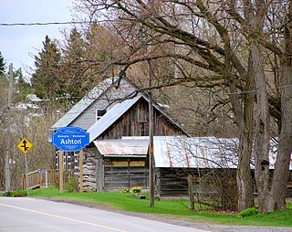
The small village of Ashton is located about 40 kilometres (25 mi) southwest of Downtown Ottawa, Ontario, at the intersection of Ashton Station Road and Flewellyn Road. Ashton Station Road runs through the centre of the community, and serves as the south-western boundary line for the City of Ottawa, thus making the eastern portion of the hamlet part of Ottawa, and the western portion part of Lanark County. The eastern portion of the community was originally part of Goulbourn Township, which was amalgamated into the City of Ottawa in 2001. It is home to approximately 200 residents.
